Method for reducing data volumes of electronic maps of navigation terminals on basis of land boundary line indexes

An electronic map and navigation terminal technology, applied in digital data processing, geographic information database, structured data retrieval, etc., can solve the problems of wasting storage resources, affecting system performance, and limited storage resources, so as to reduce storage capacity and improve System performance, the effect of reducing storage space

Active Publication Date: 2014-05-28
XIAMEN YAXON NETWORKS CO LTD
View PDF3 Cites 9 Cited by
  • Summary
  • Abstract
  • Description
  • Claims
  • Application Information

AI Technical Summary

Problems solved by technology

In navigation terminals based on embedded systems, storage resources are limited, and conventional methods of storing

Method used


Image

  • Method for reducing data volumes of electronic maps of navigation terminals on basis of land boundary line indexes
  • Method for reducing data volumes of electronic maps of navigation terminals on basis of land boundary line indexes
  • Method for reducing data volumes of electronic maps of navigation terminals on basis of land boundary line indexes

Examples


Embodiment Construction

[0021] A method for reducing the amount of electronic map data of a navigation terminal based on a land boundary index, comprising the steps of:

[0022] Step 1: Establish a land boundary index file, specifically including the following steps:

[0023] Step 11: Before building the index, it is necessary to perform thinning processing on the land boundary line to reduce the amount of data for establishing the index information of the land boundary line, and use the Douglas-Pulke thinning algorithm to perform thinning processing on the boundary line;

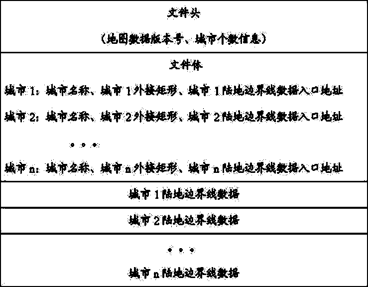
[0024] Step 12: Design the land boundary line index file, design the boundary line index file as a secondary index structure, and the index file structure is shown in Table 1:

[0025]

[0026] illustrate:

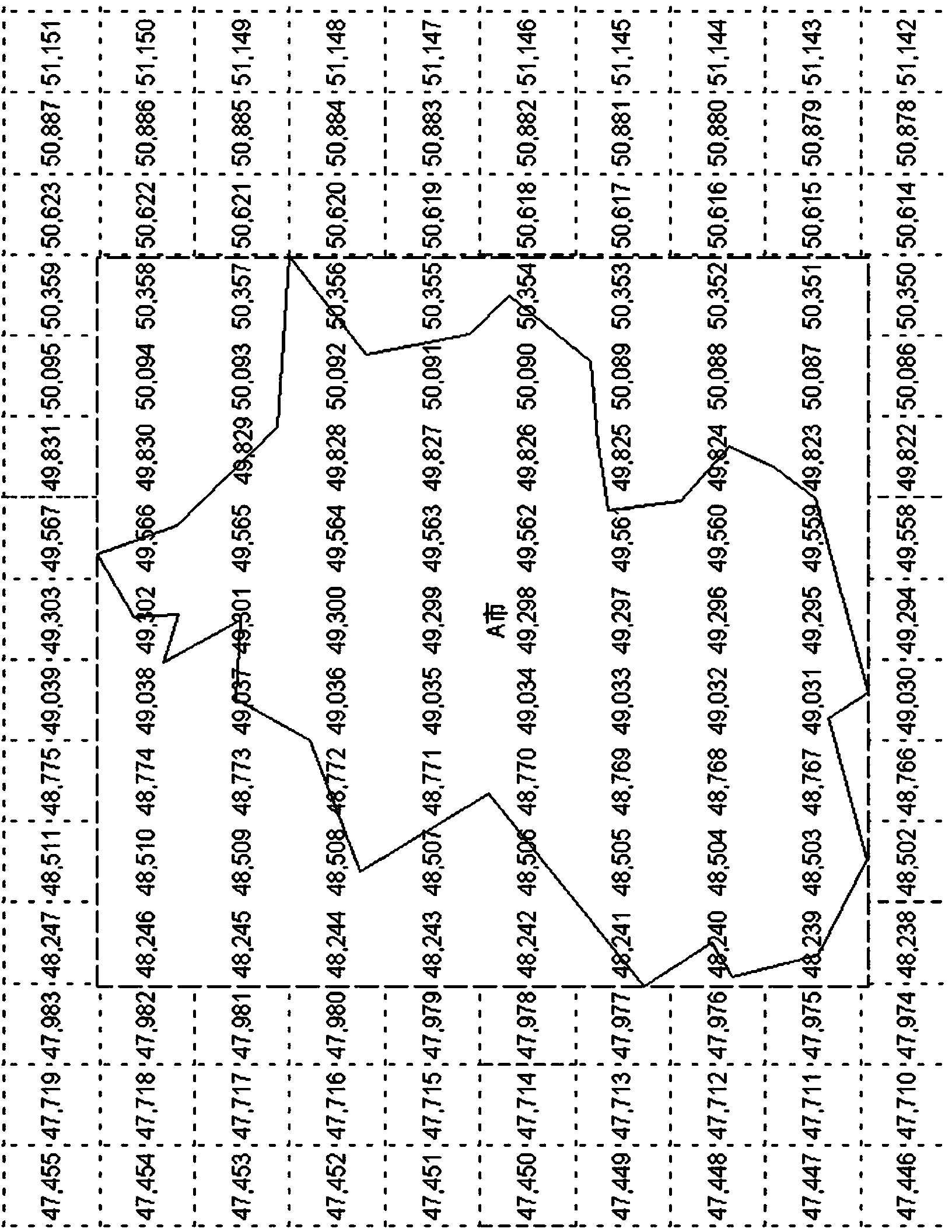
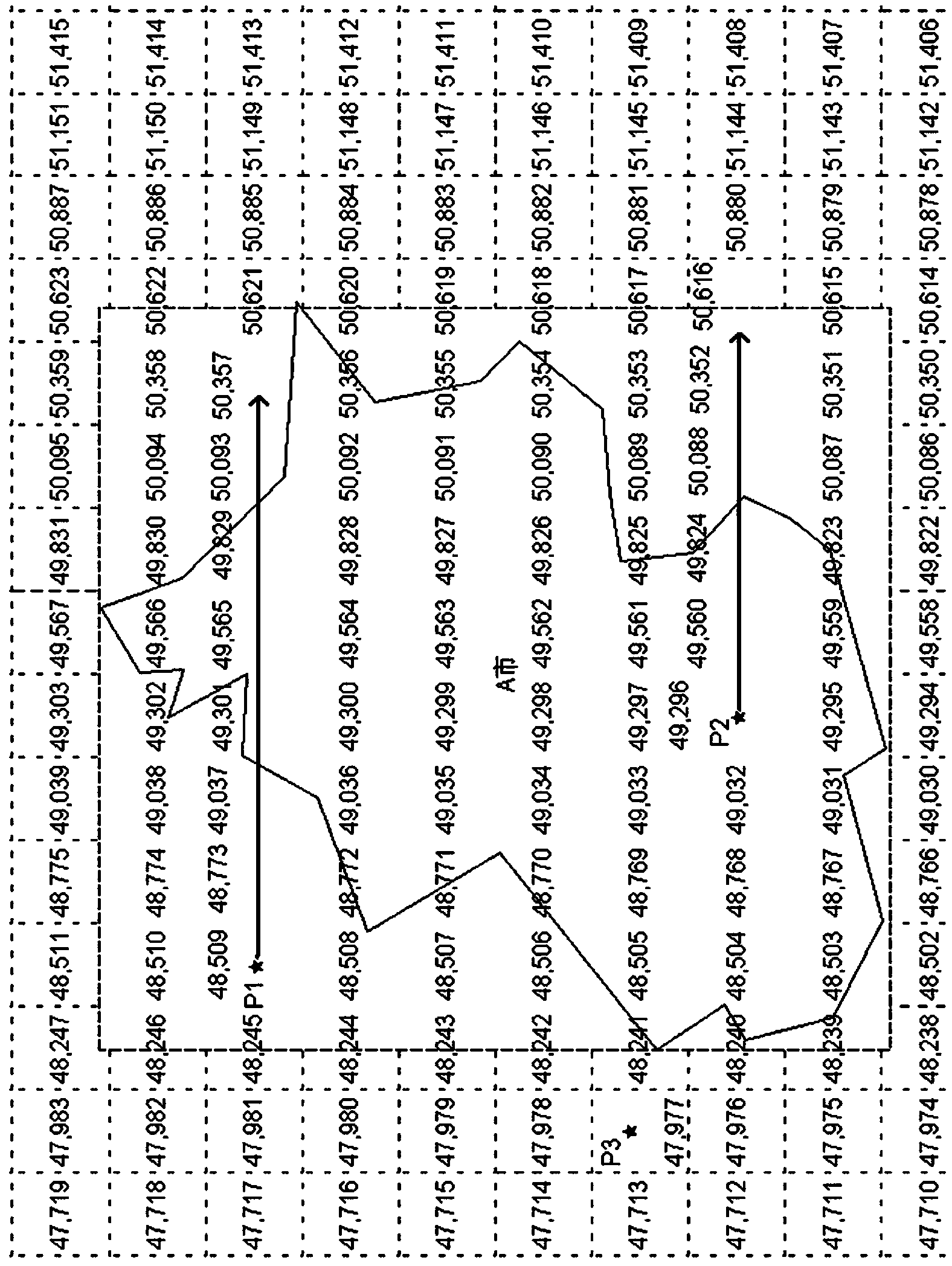
[0027] City circumscribing rectangle: the circumscribing rectangle of the city’s land boundary; for example figure 1 shown by the dotted line;

[0028] City data entry address: through this address, you can quickly jump ...


PUM


Abstract

The invention discloses a method for reducing data volumes of electronic maps of navigation terminals on the basis of land boundary line indexes. The method includes creating land boundary line index files, and specifically reducing the densities of land boundary lines by the aid of a Douglas-Peucker density reducing algorithm before the indexes are created so as to reduce data volumes of created land boundary line index information; designing the land boundary line index files into secondary index structures; judging attributes of areas of certain grids according to the land boundary line index files, and rendering backgrounds by different selected ground colors. File headers in the secondary index structures contain data versions of the maps and the numbers of cities, and file bodies in the secondary index structures contain names of the cities, bounding rectangles of the cities, land boundary line data entry addresses of the cities and land boundary line data of the cities. The certain grids only have land or ocean background data and do not have other types of geographical elements. The method has the advantages that the grids which only have the land or ocean background data do not need to be stored, and accordingly the purpose of reducing the data volumes of the electronic maps of the navigation terminals can be achieved.

Description

technical field [0001] The invention relates to embedded terminal navigation system software, in particular to a method for reducing the amount of electronic map data of a navigation terminal based on a land boundary index. Background technique [0002] On navigation terminals based on embedded systems, electronic maps are usually stored in units of grids. Under different scales, the size of the grids is different. The size of the electronic map grids under large scales is very small, and the number of grids reaches Tens of millions to trillions of levels, very large. [0003] Electronic maps have two types of background data: land and sea, which need to be rendered in different background colors. For large-area ocean data, although the amount of additional information is not much, due to the vast area of ​​the ocean, if the two types of background data are stored in the map grid data file according to the actual situation, there will be a large number of only continents or...

Claims


Application Information

Patent Timeline
IPC IPC(8): G06F17/30
CPCG06F16/29
Inventor 季刚程行荣林秋芳黄家乾韦昌荣
Owner XIAMEN YAXON NETWORKS CO LTD
Why Eureka
Try Eureka