Integration method of dynamic heterogeneous space information plotting data

A spatial information and plotting technology, which is applied in the field of spatial information data integration and processing, can solve problems such as chaotic associations, irregularities, and inconsistent data

Inactive Publication Date: 2014-06-04
BEIJING AEROSPACE TITAN TECH CO LTD
View PDF5 Cites 21 Cited by
  • Summary
  • Abstract
  • Description
  • Claims
  • Application Information

AI Technical Summary

Problems solved by technology

[0006] Spatial information plotting data comes from different databases and complex association relationships, which leads to characteristics such as data inconsistency, non-standardization, and confusion of association relationships.

Method used


Image

  • Integration method of dynamic heterogeneous space information plotting data

Examples


Embodiment Construction

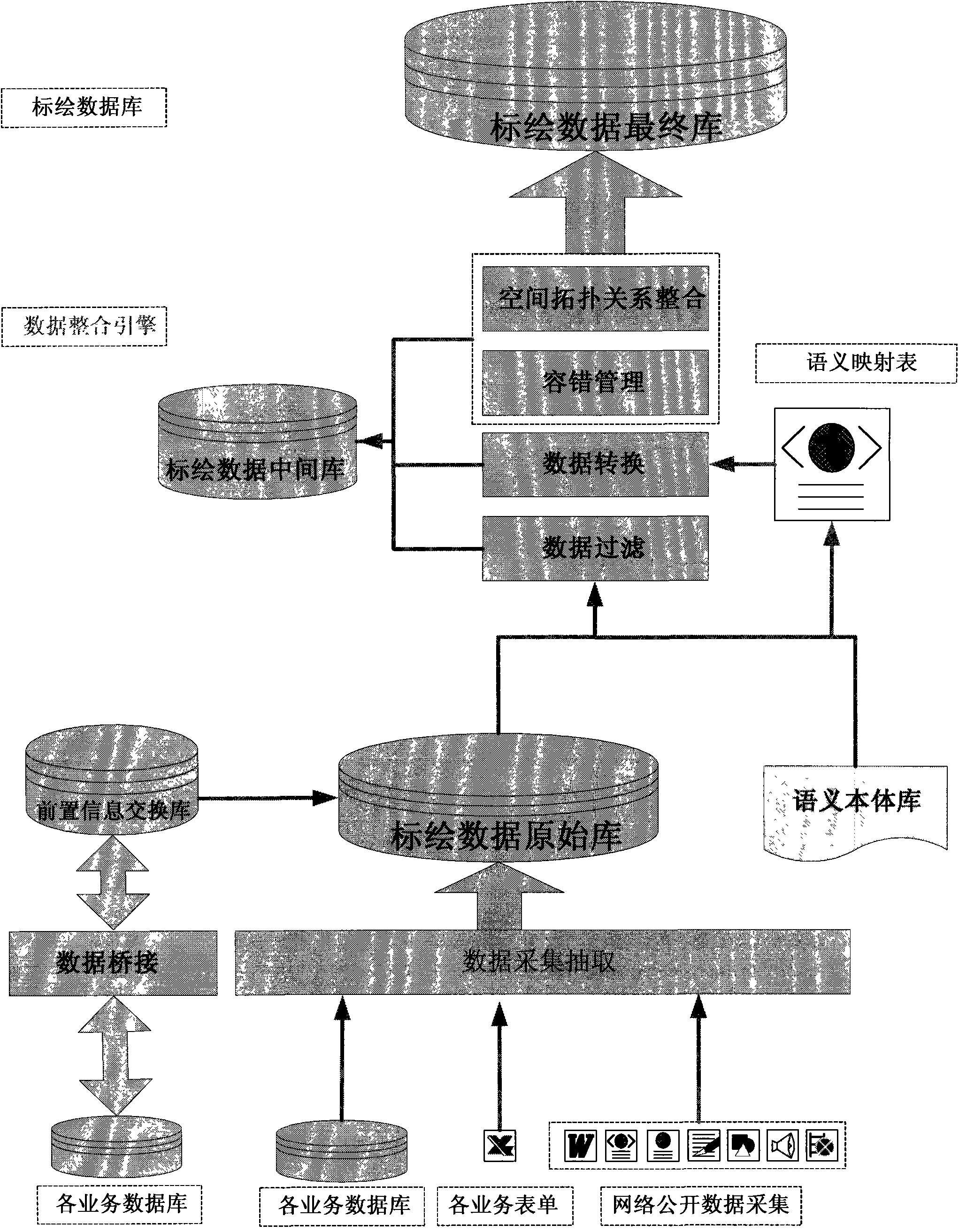
[0038] Such as figure 1 As shown, the integration method for dynamic heterogeneous spatial information plotting data belonging to the embodiment of the present invention, the entire technical solution diagram can divide the integration method for dynamic heterogeneous spatial information plotting data into establishing a semantic ontology library for plotting objects, The four technical parts of collecting and extracting plotting data, filtering and transforming plotting data, and forming the final library of plotting data mainly include the following steps:

[0039] (1) Establish a semantic ontology library for plotting objects:

[0040] The open source Protégé ontology development tool developed by Stanford Medical Infomatics of Stanford University is used to express the semantic ontology of spatial information mapping objects. The Protégé development ontology structure is displayed in a tree-like hierarchical directory structure, which can be conveniently added or edited c...


PUM


Abstract

The invention provides an integration method of dynamic heterogeneous space information plotting data. The method mainly includes the steps of semantic ontology base building, data filtering, data conversion, fault tolerance management, space topology integration and plotting data integration base forming. Firstly, a dynamic heterogeneous plotting data semantic ontology base is built, a mapping rule in ontology is declared, precise meanings of concepts are determined, and the semantic heterogeneity problem is solved; whether metadata meet a required standard or not is judged, and the data are integrated and checked; then logical operation is conducted on data items, and derived data items are generated; according to a built fault tolerance rule base, incorrect data are saved and removed; meanwhile topological relationship processing is conducted on dynamic heterogeneous data elements, and eventually a dynamic heterogeneous plotting data integration base is formed. According to the method, complex data are made to be standardized, and workloads of data maintenance and interaction can be effectively reduced. Data content is defined and converted through metadata formats, and display of plotting data has expandability and flexibility.

Description

technical field [0001] The present invention proposes a plotting data integration method through the classification organization and integration process control of spatial plotting data information, which belongs to the technical field of spatial information data integration processing, and in particular relates to an integration of dynamic heterogeneous spatial information plotting data method. It is suitable for the integration of spatial information plotting data including text, image, audio and video. Background technique [0002] Since the 1990s, with the development of information and communication technology, and the wide application of remote sensing, geographic information system and satellite positioning technology, the ways to obtain spatial information tend to be diversified, and geospatial information has grown geometrically. Spatial information data presents distinct heterogeneity, that is, it has the characteristics of multi-source, multi-scale, and multi-tem...

Claims


Application Information

Patent Timeline
Patent Type & Authority Applications(China)
IPC IPC(8): G06F17/30
CPCG06F16/21G06F16/24528
Inventor 倪金生刘翔樊军伟
Owner BEIJING AEROSPACE TITAN TECH CO LTD
Why Eureka
Try Eureka