Double-star vertex subdivision radian set fuzzy matching based marine celestial navigation method

A vertex division and fuzzy matching technology, applied in astronomical navigation, navigation, surveying and navigation, etc., can solve the problems of inertial navigation equipment error, low positioning accuracy of positioning and navigation methods, and easy interference of satellite navigation signals, so as to achieve more accurate The effect of star recognition and fast star recognition

Inactive Publication Date: 2014-06-11
HARBIN UNIV OF COMMERCE
View PDF6 Cites 6 Cited by
  • Summary
  • Abstract
  • Description
  • Claims
  • Application Information

AI Technical Summary

Problems solved by technology

[0005] The present invention aims to solve the low positioning accuracy of the existing positioning and navigation methods, the ship celestial navigation method based on the fuzzy matching of the double-star apex subdivision radian set, the positioning and navigation technology is affected

Method used


Image

  • Double-star vertex subdivision radian set fuzzy matching based marine celestial navigation method
  • Double-star vertex subdivision radian set fuzzy matching based marine celestial navigation method
  • Double-star vertex subdivision radian set fuzzy matching based marine celestial navigation method

Examples


specific Embodiment approach 1

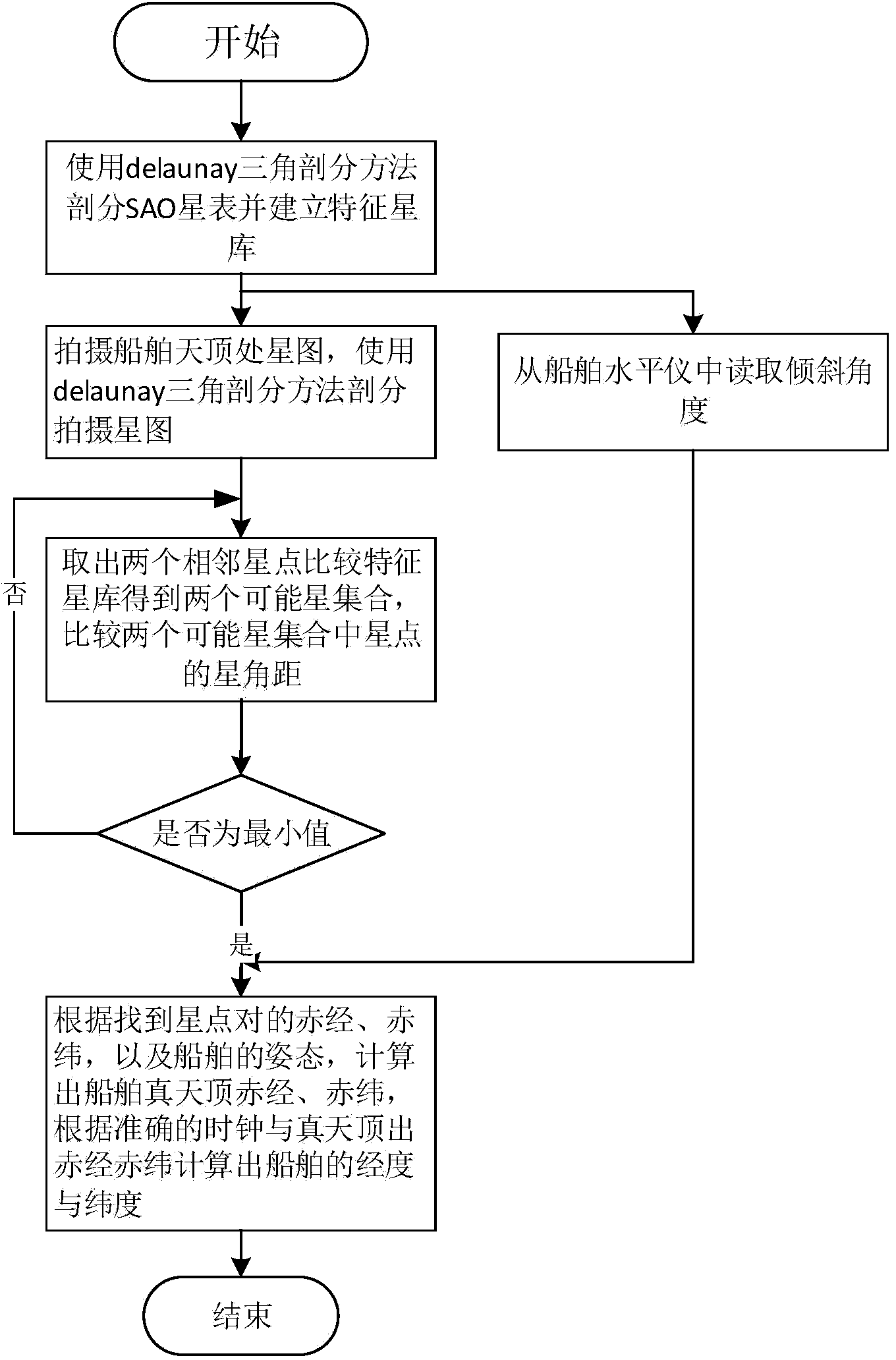
[0021] Specific implementation mode one: the ship celestial navigation method based on the fuzzy matching of double-star vertex subdivision radian set of the present embodiment comprises the following steps:

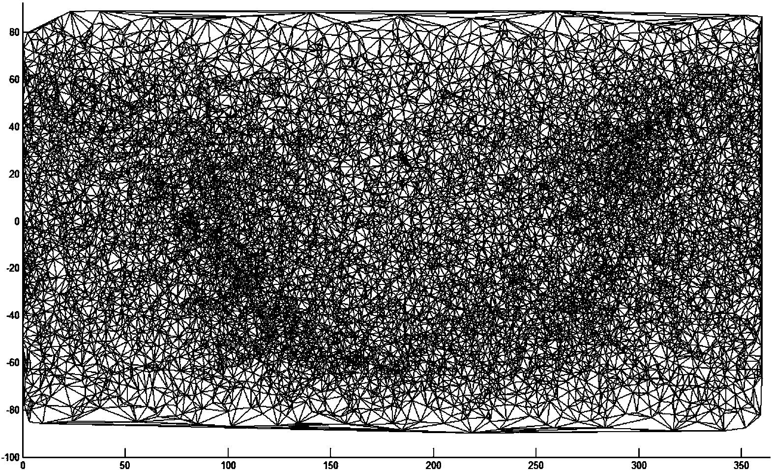
[0022] (1) Use the delaunay triangulation method to divide the Smithsonian star catalog and establish a characteristic star library;

[0023] (2) Shoot the star map vertically above the plane of the ship, use the delaunay triangulation method to divide the star map, take out the adjacent double stars from the star map, and perform fuzzy matching in the feature star library to obtain two A possible star point feature vector X, Y, while reading the angle of inclination from the ship level;

[0024] (3) Compare the star angular distance between the stars in the two possible star point feature vectors X and Y, and the one with the smallest star angular distance is the desired star pair to realize star map recognition;

[0025] (4) Determine the true zenith right ascension a...

specific Embodiment approach 2

[0026] Specific embodiment 2: The difference between this embodiment and specific embodiment 1 is that the feature star library described in step (1) uses the delaunay triangulation SAO star catalog, and each star is used as a feature mark, and the star The different radian values ​​divided by the 2π space around the star are stored in the database whose table structure is star name, radian value 1, radian value 2... radian value n, and become the feature star library.

[0027] Other steps and parameters are the same as those in Embodiment 1.

specific Embodiment approach 3

[0028] Embodiment 3: This embodiment differs from Embodiment 1 or Embodiment 2 in that: the radian subdivision vector of the double star described in step (2) performs fuzzy matching in the feature star library. The specific steps are:

[0029] 1. Take out possible star point feature vectors X and Y in the star map;

[0030] Two, fuzzy comparison of each star point feature vector feature in the feature star library with possible star point feature vectors X and Y; wherein, the specific method of the fuzzy comparison is: by comparing the difference of each star point feature vector in the feature star library To describe the average value of the metric, the Cartesian product correspondence comparison method is used to find the closest element in the possible star point feature vector X, Y:

[0031] X×Y={(xi,yi)}{(x,y)x∈X,y∈Y}

[0032] The above formula is represented by a matrix

[0033] x 1 ...


PUM


Abstract

The invention discloses a double-star vertex subdivision radian set fuzzy matching based marine celestial navigation method and relates to a marine celestial navigation method. The invention aims to solve the problems that the conventional navigation method is low in positioning accuracy, the positioning navigation technology in the double-star vertex subdivision radian set fuzzy matching based marine celestial navigation method is influenced by weather and sea conditions, a satellite navigation signal is easily interfered and inertial navigation equipment error is insufficient in divergence along with time. The method comprises the following steps: (1) dividing a Smithsonian star catalogue and establishing a characteristic star database; (2) photographing a star map perpendicular to the right above part of a ship plane; (3) comparing the star angular distance between stars in two possible star sets, wherein the stars with the minimum star angular distance refer to the solved star pair, and realizing star map recognition; and (4) determining the true zenith right ascension and declination according to an inclination angle read by the ship during photographing, combining the exact time, namely the double-star vertex subdivision radian set fuzzy matching-based marine celestial navigation method is finished. The method belongs to the technical field of marine navigation.

Description

technical field [0001] The invention relates to a ship celestial navigation method. Background technique [0002] At present, there are three kinds of celestial navigation architectures at home and abroad. The first was a celestial navigation system based on the sextant used in navigation. After World War II, this method began to be widely used. In today's ship navigation with the development of advanced navigation technology, there are still vernier caliper sextant and mechanical sextant navigation means. Orientation, this method of mechanical sextant navigation, became an essential nautical skill. Of course, this technology and equipment have evolved into an electronic sextant. But the degree of autonomy and automation of such systems is relatively low. The astronomical almanac in the computer is queried to obtain the Green hour angle and declination information of the stars, combined with the altitude information of the observed celestial body, and its specific positi...

Claims


Application Information

Patent Timeline
IPC IPC(8): G01C21/02
CPCG01C21/02G01C21/203
Inventor 孙剑明赵志杰韩雪娜王志浩孙华东
Owner HARBIN UNIV OF COMMERCE
Why Eureka
Try Eureka