Satellite positioning data transmission method

A data transmission method and satellite positioning technology, applied in digital transmission systems, transmission systems, services based on location information, etc., can solve problems such as long data transmission time

Active Publication Date: 2014-06-18
杭州承联通信技术有限公司
View PDF3 Cites 15 Cited by
  • Summary
  • Abstract
  • Description
  • Claims
  • Application Information

AI Technical Summary

Problems solved by technology

[0005] The mobile terminal needs to send 57 bits of data each time it transmits satellite positioning data, and the data transmission takes a long time

Method used


Image

  • Satellite positioning data transmission method
  • Satellite positioning data transmission method
  • Satellite positioning data transmission method

Examples


Embodiment 1

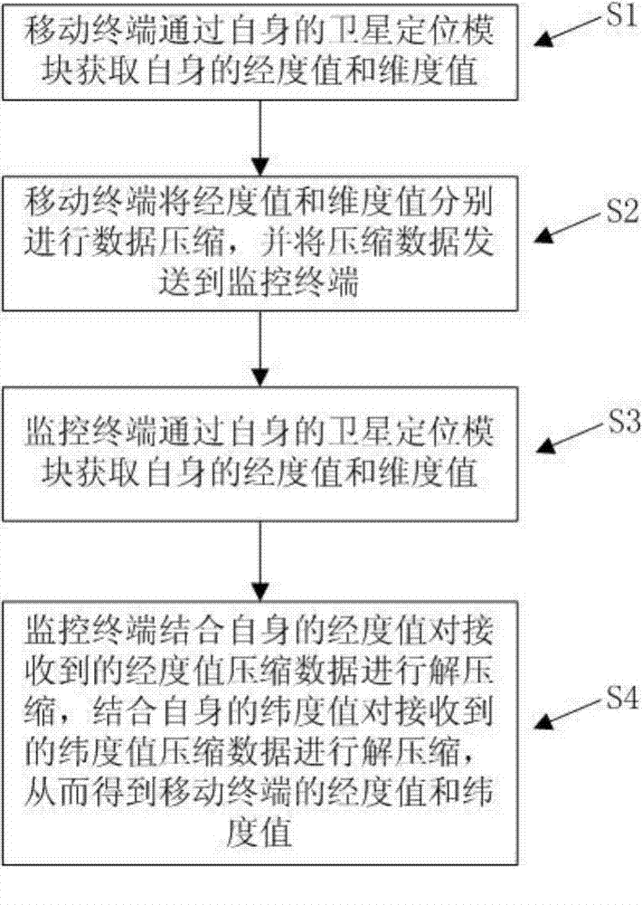
[0028] Embodiment 1: A satellite positioning data transmission method of this embodiment is used in a PDT wireless trunking communication system. The PDT wireless trunking communication system includes a mobile terminal and a monitoring terminal, and the longitude distance between the location of the mobile terminal and the location of the monitoring terminal is less than 8 degrees, the latitude distance is less than 2 degrees, such as figure 1 shown, including the following steps:

[0029] S1: The mobile terminal acquires its own longitude and latitude values ​​through its own satellite positioning module;

[0030] S2: The mobile terminal performs data compression on the longitude value and the latitude value respectively, and sends the compressed data to the monitoring terminal;

[0031] S3: The monitoring terminal obtains its own longitude and latitude values ​​through its own satellite positioning module;

[0032] S4: The monitoring terminal decompresses the received lon...

Embodiment 2

[0061] Embodiment 2: the method of this embodiment is basically the same as embodiment 1, the difference is:

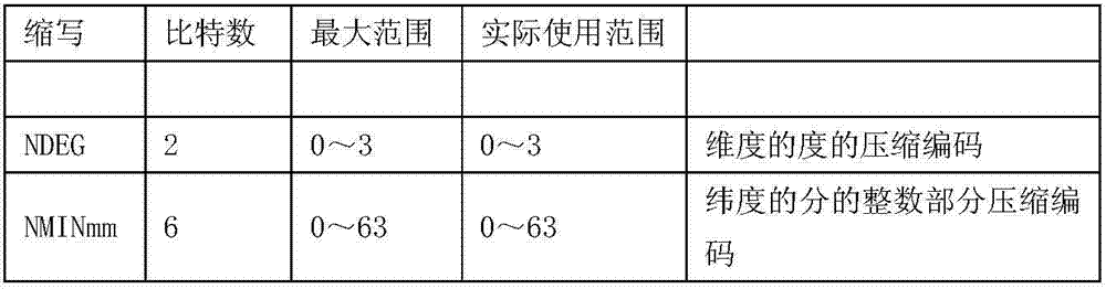
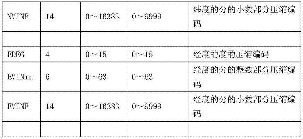
[0062] The method for compressing the longitude value of the mobile terminal in step S2 includes the following steps: when the longitude position of the monitoring terminal is between 0 degree meridian and east longitude 171 degrees (including 0 degree meridian and east longitude 171 degrees) or between 0 degree meridian and west longitude 171 degrees (including west longitude 171 degrees), the mobile terminal converts the decimal longitude value into the corresponding coded data, if the longitude value is located on the east longitude or 0 degree longitude, then the mobile terminal converts the value of the degree of longitude into an 8-bit binary code, Remove the upper 4 bits of the binary code, use the lower 4 bits of the binary code as the encoding of the degree, convert the value of the integer part of the longitude into a 6-bit binary code as the encoding of the ...


PUM


Abstract

The invention discloses a satellite positioning data transmission method, which comprises the following steps that a mobile terminal acquires the longitude value and the dimension value of the mobile terminal through a satellite positioning module of the mobile terminal, the mobile terminal performs data compression on the longitude value and the dimension value respectively, and sends the compressed data to a monitoring terminal, and the monitoring terminal acquires the longitude value and the dimension value of the monitoring terminal through a satellite positioning module of the monitoring terminal, performs uncompressing on the received longitude value compressed data according to the longitude value of the monitoring terminal, and performs uncompressing on the received dimension value compressed data according to the dimension value of the monitoring terminal, so that the longitude value and the dimension value of the mobile terminal are obtained. The data length of satellite positioning data transmitted by the mobile terminal each time can be shortened, so that the data transmission time is reduced.

Description

technical field [0001] The invention relates to the technical field of data transmission, in particular to a satellite positioning data transmission method. Background technique [0002] In a professional wireless trunking communication system, it is a very urgent requirement for dispatching commanders or managers to know the actual geographic location information of mobile users. However, uploading satellite positioning information takes time, so the number of users uploading satellite positioning information using a certain number of channels within a certain period of time is limited. We always hope that the more users who upload satellite positioning information, the better. The current satellite positioning data transmission method is that the mobile terminal transmits the absolute value of its own satellite positioning information. This method transmits a large amount of data each time, and the length of the transmitted data is shown in Table 1. [0003] abb...

Claims


Application Information

Patent Timeline
Patent Type & Authority Applications(China)
IPC IPC(8): H04W4/02H04L1/00
Inventor 宋飞浩陈焕明曹健刘庆江
Owner 杭州承联通信技术有限公司
Why Eureka
Try Eureka