Submergence assisted geomagnetic anomaly inversion velocity measurement/underwater continuous positioning method

A technology of geomagnetic anomaly and positioning method, which is applied in the direction of using a device that measures the time required to move a certain distance, ground navigation, and navigation through speed/acceleration measurement, etc. interference, etc.

Inactive Publication Date: 2014-07-02
HARBIN ENG UNIV
View PDF2 Cites 15 Cited by
  • Summary
  • Abstract
  • Description
  • Claims
  • Application Information

AI Technical Summary

Problems solved by technology

However, the composition of the underwater geomagnetic field is relatively complex, and the marine magnetic survey is also subject to many interferences. It is difficult to effectively construct the underwater geomagnetic navigation reference map. At the same time, there are some obstacles in the traditional geomagnetic mat

Method used


Image

  • Submergence assisted geomagnetic anomaly inversion velocity measurement/underwater continuous positioning method
  • Submergence assisted geomagnetic anomaly inversion velocity measurement/underwater continuous positioning method
  • Submergence assisted geomagnetic anomaly inversion velocity measurement/underwater continuous positioning method

Examples


Embodiment Construction

[0037] Attached below Figure 1~4 The present invention is described in detail:

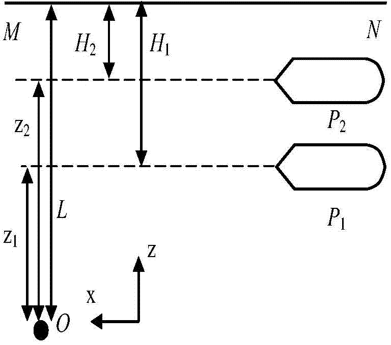
[0038] The present invention relates to a depth-assisted geomagnetic anomaly inversion speed measurement / underwater continuous positioning method. The three-axis magnetometer group strapped down to the underwater vehicle measures the dipole target magnetic field gradient tensor, and is strapped down to the measurement of the underwater vehicle. The carrier submerged depth of the deep instrument, the position of the carrier relative to the target magnetic field is obtained from the relationship between the dipole target magnetic field gradient tensor and the carrier submerged depth and the position of the carrier, and the distance of the carrier relative to the target magnetic field is further obtained, and the positioning distance at different times is used to calculate Carrier ground speed. According to the gradient tensor of the target magnetic field and the relationship between the relative p...


PUM


Abstract

The invention provides a submergence assisted geomagnetic anomaly inversion velocity measurement/underwater continuous positioning method. The submergence assisted geomagnetic anomaly inversion velocity measurement/underwater continuous positioning method comprises the following steps: measuring the distance from a carrier to the sea level and dipole target magnetic field gradient tensor information at different submergence parts by a depth finder and a magnetometer and calculating the relative position of the carrier; calculating the ground velocities of the carrier according to positioning distances of different moments; and calculating a target magnetic moment measuring value according to a relation of a target magnetic field gradient tensor and a target magnetic moment and a relation of a relative position coordinate of the carrier and the target magnetic moment. According to the characteristic that the target magnetic moment is not changed, a nonlinear equation set about carrier position parameters is formed by the target magnetic moment and a target magnetic field gradient tensor measured value; a relative coordinate parameter of the carrier is solved by the target magnetic field gradient tensor measuring value so as to realize the continuous positioning. In the process of measuring a target magnetic field gradient tensor, the influences caused by ocean current, wind current, carrier posture change and the like do not need to be considered and the carrier does not need to be continuously and vertically moved; the hidden property and the measurement precision are good.

Description

technical field [0001] The invention belongs to the field of underwater geomagnetic-assisted navigation and positioning, in particular to a depth-assisted geomagnetic anomaly inversion speed measurement / underwater continuous positioning method. Background technique [0002] As the inherent physical field of the earth, the geomagnetic field is an available natural resource for ship positioning, attitude control and navigation. As a strict passive navigation, geomagnetic navigation does not need to accept external or radiated energy, which ensures the concealment and autonomy of the carrier. In order to realize the long-term concealed navigation of underwater vehicles, research institutions and scholars at home and abroad have carried out research on geomagnetic-assisted navigation. In the 1980s, Tyren C of Lund College in Sweden studied the method of manual comparison between geomagnetic intensity measurement data and geomagnetic maps to determine the ship's position, and de...

Claims


Application Information

Patent Timeline
IPC IPC(8): G01C21/08G01C21/16G01P3/64
CPCG01C21/08G01C21/16G01P3/66
Inventor 武立华黄玉
Owner HARBIN ENG UNIV
Why Eureka
Try Eureka