Eureka AIR delivers breakthrough ideas for toughest innovation challenges, trusted by R&D personnel around the world.

A navigation method for an electronic device and an electronic device

A technology of electronic equipment and navigation method, applied in the field of navigation, can solve problems such as poor signal or even shielded signal, inability to locate or locate electronic equipment, etc., to reduce errors, improve inconvenience, and improve navigation experience.

Active Publication Date: 2017-01-25
SHENZHEN WATER WORLD INFORMATION CO LTD
View PDF7 Cites 0 Cited by
  • Summary
  • Abstract
  • Description
  • Claims
  • Application Information

AI Technical Summary

Problems solved by technology

[0002] At present, map navigation applications have been more and more widely used in people's handheld devices and vehicle-mounted devices. Map navigation now mostly relies on GPS positioning and mobile communication networks for base station positioning, but there are still influences due to certain factors. Unable to locate, for example, when GPS signals and base station signals have blind spots in remote areas, it is impossible to locate; in some tunnels, culverts and underground parking lots, due to poor signals or even shielded signals, it is impossible to locate and other reasons may make it impossible for electronic devices to locate

Method used


Image

  • A navigation method for an electronic device and an electronic device
  • A navigation method for an electronic device and an electronic device
  • A navigation method for an electronic device and an electronic device

Examples


Embodiment 1

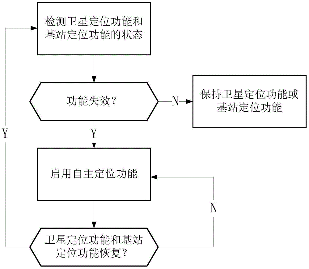
[0049] This embodiment discloses a navigation method for an electronic device in the case of a single road by using a three-axis gyroscope to collect acceleration information:

[0050] figure 2 It is the flow chart of step S2 of this embodiment, combined with figure 1 It can be seen that the step S2 includes the process:

[0051] S2-1: Read the acceleration information of the three-axis gyroscope, and judge whether the acceleration information of the electronic device changes. If the acceleration information remains unchanged, go to step S2-2; if the acceleration information changes, go to step S2-3;

[0052] S2-2: Calculate the displacement according to the initial speed information, acceleration information and preset time interval, and update the current positioning information on the electronic map; return to step S2-1;

[0053] S2-3: Calculate the displacement according to the initial speed information, acceleration information and the time before the acceleration chan...

Embodiment 2

[0062] This embodiment discloses a navigation method for electronic equipment in the case of multiple roads by using a three-axis gyroscope to collect acceleration information; using a compass to collect the movement direction:

[0063] Figure 4 It is a flow chart of step S2 in this embodiment, and the step S2 includes the process:

[0064] S2-1: Read the movement direction information of the compass, record the movement direction when it fails as the initial movement direction, record the road where the failure occurs as the initial road, read the acceleration information of the three-axis gyroscope, and judge the electronic equipment Whether the direction of motion of the device changes, if the direction of motion remains unchanged, go to step S2-2; if the direction of motion changes, go to step S2-3;

[0065] S2-2: Calculate the displacement according to the initial speed information, acceleration information and the preset time interval, and update the current positionin...

Embodiment 3

[0075] The invention also discloses an electronic device. Such as Figure 6 As shown, the electronic equipment includes a processing module (CPU) 10, a GPS navigation module 1 coupled with the processing module (CPU) 10, a mobile communication module 2, an autonomous positioning module 3 and a storage unit; the mobile communication module 3 is used for base station positioning; Wherein the autonomous positioning module 3 includes a gravity sensing unit 31 for sampling acceleration information and a pointing unit 32 for sampling motion direction information;

[0076] When the function failure of GPS navigation module 1, mobile communication module 2, processing module (CPU) 10 records the location information when failure as initial location information to storage unit; Autonomous positioning module 3 calculates displacement based on initial location information; Processing module 10 Update the current positioning information to the electronic map according to the displacement...


PUM


Abstract

The invention discloses an electronic device and a navigation method thereof. The navigation method of the electronic device comprises the following steps: S1, detecting the state of a satellite positioning function and the state of a base station positioning function, and if the satellite positioning function and the base station positioning function are invalid, recording positioning information when the two functions are invalid as primary positioning information and starting a self-positioning function; S2, calculating displacement by the self-positioning function based on the primary positioning information and updating current positioning information on an electronic map; S3, detecting the state of the satellite positioning function and the state of the base station positioning function again, and if the satellite positioning function and the base station positioning function are restored, closing the self-positioning function, restarting the satellite positioning function and the base station positioning function and returning to the step S1, or returning to the step S2 if the satellite positioning function and the base station positioning function are not restored. By adopting the electronic device, users can implement self-navigation in dead zones of satellite positioning signals and mobile communication signals through the method.

Description

technical field [0001] The present invention relates to the field of navigation, and more specifically, relates to a navigation method of an electronic device and an electronic device. Background technique [0002] At present, map navigation applications have been more and more widely used in people's handheld devices and vehicle-mounted devices. Map navigation now mostly relies on GPS positioning and mobile communication networks for base station positioning, but there are still influences due to certain factors. Unable to locate, for example, when GPS signals and base station signals have blind spots in remote areas, it is impossible to locate; in some tunnels, culverts and underground parking lots, due to poor signals or even shielded signals, it is impossible to locate and other reasons All may make the electronic device unable to locate. Contents of the invention [0003] The technical problem to be solved by the present invention is to provide a navigation method an...

Claims


Application Information

Patent Timeline
Patent Type & Authority Patents(China)
IPC IPC(8): G01C21/28G01S19/49
CPCG01C21/28G01S19/06G01S19/49
Inventor 罗金辉
Owner SHENZHEN WATER WORLD INFORMATION CO LTD
Why Eureka
Eureka Blog
Learn More