Method for inverting ground surface temperature through VIIRS data

A technology of surface temperature and data, applied in radiation pyrometry, ICT adaptation, electromagnetic wave re-radiation, etc., can solve problems such as affecting inversion accuracy, and achieve the effect of simplified calculation and efficient operation of business operation.

Inactive Publication Date: 2014-07-30
INST OF AGRI RESOURCES & REGIONAL PLANNING CHINESE ACADEMY OF AGRI SCI +2
View PDF3 Cites 10 Cited by
  • Summary
  • Abstract
  • Description
  • Claims
  • Application Information

AI Technical Summary

Problems solved by technology

[0007] The purpose of the present invention is to provide a method for inversion of surface temperature from remote sensing data V

Method used


Image

  • Method for inverting ground surface temperature through VIIRS data
  • Method for inverting ground surface temperature through VIIRS data

Examples


Embodiment Construction

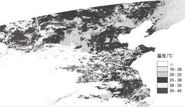
[0033] The VIIRS data of the Chinese region imaged at 05:16 (UTC) on September 26, 2013, and the Aqua MODIS data of the Chinese region at 05:35 (UTC) on September 26, 2013 were used for specific measurements.

[0034] The first step is to calculate the regional water vapor corresponding to VIIRS from the MODIS water vapor data.

[0035] 1-1) Perform projection conversion on MODIS and VIIRS data, and use the equal longitude and latitude search method to obtain VIIRS water vapor data. This invention is implemented by programming under ENVI, mainly using the envi_convert_file_coordinates function.

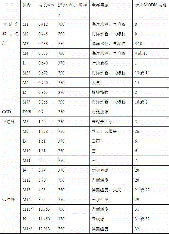
[0036] 1-2) Look up the transmittance of VIIRS M15 and M16 channels through the MODTRAN water vapor transmittance lookup table. Table 2 lists the transmittance under some atmospheric water vapor contents.

[0037] Water vapor / g.cm -2 0.40 0.80 1.20 1.60 2.00 2.40 2.80 3.20 3.60 4.00 4.40 4.80 M15 transmittance 0.94 0.91 0.88 0.84 0.80 0.75 0.70 0.65...


PUM


Abstract

The invention relates to a method for acquiring the ground surface temperature through NPPVIIRS data. By means of the method, appropriate ground surface temperature data can be provided for weather, agriculture drought and environment monitoring. The method overcomes the defect that due to the fact that a VIIRS sensor is not provided with a moisture channel, the inversion precision is limited. According to the method, MODIS sensor moisture data carried by an Aqua satellite operating at a sun-synchronous orbit with the descending node being 13: 30 are used for acquiring the moisture data of VIIRS data observation swath. The ground surface temperature inversion algorithm suitable for 11 microns and 12 microns of the VIIRS sensor is derived, an atmospheric radiation transfer model MODTRAN4 is used for simulating and calculating the transmittance of an M15 channel and the transmittance of an M16 channel of the VIIRS sensor under different atmospheric moisture contents (0.4-6.0 g/cm<2>, and increasing is carried out with 0.1 g/cm<2> as the step size), the emissivity of ground features corresponding to the M15 channel and the emissivity of ground features corresponding to the M16 channel of the VIIRS sensor are estimated according to International Geosphere Biosphere Program (IGBP) data, and finally the inverting of the ground surface temperature is obtained. According to the method, study is carried out on the inversion of the ground surface temperature based on the VIIRS sensor, and stable transmission from the MODIS data to the VIIRS data in the agriculture environment data monitoring is facilitated.

Description

technical field [0001] The invention relates to a method for retrieving land surface temperature by using ground thermal infrared information obtained by a VIIRS sensor carried by an earth observation satellite NPP. The method overcomes the disadvantage that the VIIRS sensor has no water vapor channel to limit the inversion accuracy. It can be applied to remote sensing departments such as meteorology, agricultural drought and environmental monitoring. Background technique [0002] The long-wave radiation emitted by the surface is the main source of atmospheric heat, so the surface temperature parameters are widely used to monitor changes in the global environment. In addition, due to the need to continuously and stably obtain the surface temperature on a large scale, it is only possible to retrieve the surface temperature from satellite data. Most of the algorithms for retrieving land surface temperature from satellite data are different inversion methods designed for diffe...

Claims


Application Information

Patent Timeline
IPC IPC(8): G01S17/95
CPCG01J5/007Y02A90/10
Inventor 不公告发明人
Owner INST OF AGRI RESOURCES & REGIONAL PLANNING CHINESE ACADEMY OF AGRI SCI
Why Eureka
Try Eureka