Multielement remote sensing information coordinated snow cover parameter inversion method

A technology of parameter inversion and snow cover, applied in the field of remote sensing image processing, can solve problems such as difficulty in accurately distinguishing thick clouds and snow, inability to judge cloud and snow coverage, etc., and achieve the effect of improving accuracy, accuracy and integrity.

Inactive Publication Date: 2014-08-13
INST OF REMOTE SENSING & DIGITAL EARTH CHINESE ACADEMY OF SCI
View PDF3 Cites 25 Cited by
  • Summary
  • Abstract
  • Description
  • Claims
  • Application Information

AI Technical Summary

Problems solved by technology

For the parameter of snow cover, the current inversion method mainly uses optical remote sensing data, it is difficult to accurately distinguish between thick clouds and snow, and it is impossible to judge the snow cover under the cloud; for the inversion of the parameter of snow depth, the main Passive microwave data is used, but there is a large error when the snow depth is less than 5cm

Method used


Image

  • Multielement remote sensing information coordinated snow cover parameter inversion method
  • Multielement remote sensing information coordinated snow cover parameter inversion method
  • Multielement remote sensing information coordinated snow cover parameter inversion method

Examples


Embodiment Construction

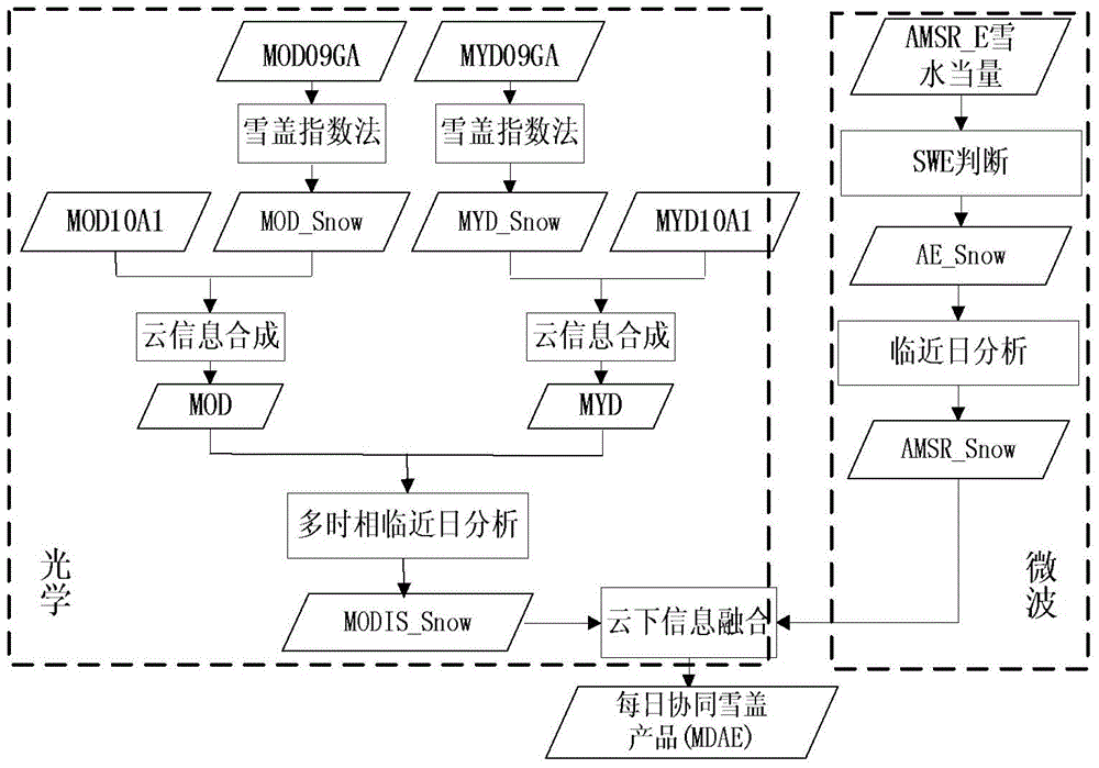
[0028] like figure 1 Shown:

[0029] 1. Snow cover inversion

[0030] Step 1: Set the rules for snow cover information extraction of MODIS albedo products:

[0031] B2>0.11

[0032] B4>0.1

[0033]

[0034] NDVI>0.1, 0

[0035] Based on MODIS albedo products MOD09GA and MYD09GA, using the above snow information extraction rules, the snow extraction results MOD_Snow and MYD_Snow can be obtained respectively.

[0036] Step 2: Combine the snow cover extraction result MOD_Snow of NDSI and the cloud information in the MOD10A1 snow cover product to obtain the MOD of the snow, cloud and land distribution result of Morning Star. The fusion rules of MYD_Snow and MYD10A1 snow cover products are the same, and the distribution result MYD of snow, clouds and land in the afternoon star is obtained. Using the snow discrimination results of MOD and MYD in different phases can avoid the lack of image cracks and obtain MOYD by fusion.

[0037] ...


PUM


Abstract

The invention relates to a multielement remote sensing information coordinated snow cover parameter inversion method. The normalized vegetation / snow cover indexes are calculated by utilizing a green ray waveband and short wave infrared of two data sources Terra and Aqua and are combined with a near-infrared band and the green ray waveband to obtain a snow cover inversion result at an initial stage, multi-temporal coordinated cloud removing processing is carried out on the snow cover inversion result, and coordinated multi-temporal microwave data generate a final snow cover inversion product; the snow depth is inversed by utilizing passive microwave data, the snow depth which is greater than 5cm is taken as an effective value and is combined with a microwave snow cover classification chart for performing multi-temporal coordination, the snow depth which is smaller than or equal to 5cm is taken as pixel values which are expressed by an optical data inversion result and is combined with an optical snow cover classification chart for improving the inversion precision, and the microwave inversion result and the optical inversion result are coordinated for generating a final snow depth inversion product. The multielement remote sensing information coordinated snow cover parameter inversion method has the beneficial effects that the precision and the integrity of snow cover parameter inversion are high, and for inversion of the snow depth which is smaller than or equal to 5cm, an optical data inversion formula is invented, so that the method makes up the blank of inversion in a shallow snow area.

Description

technical field [0001] The invention relates to the technical field of remote sensing image processing, in particular to a snow cover parameter inversion method based on multi-element remote sensing information coordination. Background technique [0002] Snow is one of the most active natural elements on the surface of the earth. It has the characteristics of strong seasonality, wide distribution and high albedo. Its characteristics such as snow cover (hereinafter referred to as snow cover) and snow depth (hereinafter referred to as snow depth) are It is an important factor in the study of climate change, surface radiation balance, hydrological cycle, etc., and is also the main input parameter in the global water energy balance model, among which snow cover and snow depth are the most important snow parameters. Snow cover and snow depth are sensitive indicators of climate change. Climate change at any time and space scale is accompanied by snow fluctuations of different scal...

Claims


Application Information

Patent Timeline
Patent Type & Authority Applications(China)
IPC IPC(8): G06F19/00
Inventor 王思远张佳华尹航殷慧常清孙云晓杨柏娟汪箫悦彭瑶瑶
Owner INST OF REMOTE SENSING & DIGITAL EARTH CHINESE ACADEMY OF SCI
Why Eureka
Try Eureka