Automatic detection method of road centerline in multi-spectral remote sensing images

A remote sensing image and automatic detection technology, applied in the field of remote sensing image road target detection, can solve problems such as wrong segmentation and blurred road boundaries, and achieve the effects of fast processing speed, reduced manual operation, and simple morphological operation.

Active Publication Date: 2017-03-01
XIDIAN UNIV
View PDF4 Cites 0 Cited by
  • Summary
  • Abstract
  • Description
  • Claims
  • Application Information

AI Technical Summary

Problems solved by technology

The disadvantage of this method is that the buildings on the edge of the road and the road surface present approximate grayscale features, resulting in blurred road boundaries and incorrect segmentation.

Method used


Image

  • Automatic detection method of road centerline in multi-spectral remote sensing images
  • Automatic detection method of road centerline in multi-spectral remote sensing images
  • Automatic detection method of road centerline in multi-spectral remote sensing images

Examples


Embodiment Construction

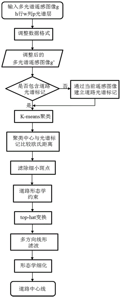
[0030] The implementation and effects of the present invention will be further described in detail below in conjunction with the accompanying drawings.

[0031] refer to figure 1 , the implementation steps of the present invention are as follows:

[0032] Step 1, input the multispectral remote sensing image g, the number of rows of the multispectral remote sensing image is h, the number of columns is w, and the number of spectral layers is p, where h>0, w>0, p≥4.

[0033] Step 2: Adjust the cumulative histogram for each spectral layer of the multispectral remote sensing image g to obtain the adjusted multispectral remote sensing image g'.

[0034] (2a) Save the sub-image of the kth spectral layer in the multispectral remote sensing image g as g k , k=1...p, calculate the sub-image g k The minimum gray value min k and the maximum gray value max k , and at min k ~max k Do subimage g in the range k cumulative histogram of

[0035] (2b) will accumulate the histogram fig...


PUM


Abstract

The invention discloses a road center line auto-detection method employing multispectral remote sensing images. The method includes the steps of 1, inputting a multispectral remote sensing image and adjusting data format thereof; 2, subjecting the adjusted multispectral remote sensing image to road spectral marking; 3, calculating a cluster center of the multispectral remote sensing image and a category number thereof; 4, comparing distances of the cluster center and a road spectral mark to obtain a road category number; 5, setting a gray level of corresponding pixels of the road category number as 1 so as to obtain a binary image; 6, filtering a fine spot area from the binary image to obtain a denoised image; 7, filtering a non-road-feature area from the denoised image to obtain a feature image; 8, filtering a building and road coupling area to obtain an area image; 9, extracting a road center line from the area image. The road center line auto-detection method has the advantages that detection performance is high and area adaptability is high; the road center line auto-detection method is applicable to detection of road center lines in outskirt multispectral remote sensing images and road center lines in urban multispectral remote sensing images.

Description

technical field [0001] The invention belongs to the technical field of image processing, and relates to object detection of remote sensing images, in particular to a road object detection method of remote sensing images. This method is suitable for automatic detection of road targets. Background technique [0002] Multispectral remote sensing images are high-resolution images obtained by scanning the ground with satellite multispectral scanning systems. Its rich spectral information provides the possibility for computer recognition and detection of ground object images. However, due to its low spectral dimension and low spatial resolution, the extraction of land use and coverage information has become one of the difficulties in remote sensing information processing. As an important man-made feature, roads are the main body of the modern transportation system and have important geographical, political, and economic significance. Roads are also the main records and identifica...

Claims


Application Information

Patent Timeline
Patent Type & Authority Patents(China)
IPC IPC(8): G06K9/62G06K9/46
Inventor 李洁王颖李圣喜高新波高宪军吴晟杰张琪逄敏田春娜王秀美
Owner XIDIAN UNIV
Why Eureka
Try Eureka