Virtuality-reality integrated three-dimensional display method and virtuality-reality integrated three-dimensional display system

A technology of three-dimensional display and display method, applied in the field of geographic information system, can solve problems such as unrealistic correlation and complexity, lack of spatial coordinates of nodes, lack of real space coordinates of network elements in the Internet, etc.

Active Publication Date: 2014-09-24
SHENZHEN INST OF ADVANCED TECH
View PDF4 Cites 46 Cited by
  • Summary
  • Abstract
  • Description
  • Claims
  • Application Information

AI Technical Summary

Problems solved by technology

Due to the lack of spatial coordinates of nodes, its spatial position is difficult to accurately reflect, and it is only spatially schematic
[0006] The above two schemes have partially solved the relationship between "virtual-reality" space interaction, but there are the following problems: First, the integrated expression of the dual space cannot be realized, the elements and relationships of both parties are not placed in the same coordinate system, and there is a lack of space Structural realism cannot realize its relevance and complexity; secondly, the lack of real space coordinates of network elements in the Internet makes it impossible to accurately locate; thirdly, the two-dimensional map display effect is not good, it is easy to block each other, and the amount of information is limited

Method used


Image

  • Virtuality-reality integrated three-dimensional display method and virtuality-reality integrated three-dimensional display system
  • Virtuality-reality integrated three-dimensional display method and virtuality-reality integrated three-dimensional display system
  • Virtuality-reality integrated three-dimensional display method and virtuality-reality integrated three-dimensional display system

Examples


Embodiment 1

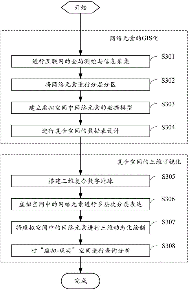
[0026] see image 3 , which is a schematic diagram of the "virtual-reality" integrated display method in the present invention. The display method is used to display virtual network elements and real physical objects in a geographic information system (GIS) to form a composite space, which mainly includes two steps: one is: to convert the network elements of the virtual space into a GIS ; The second is: compound space for three-dimensional visualization. in particular:

[0027] 1. Make the network elements of the virtual space GIS

[0028] In the face of the Internet's "virtual-reality" space interweaving and combining, it is necessary to virtualize and expand traditional GIS data functions to solve the mapping of network elements and behaviors in real space.

[0029] Such as Figure 4 The shown "virtual-reality" integrated CYBER-GIS spatial logic, in this embodiment, the traditional data structure of GIS is extended, and the real space (X, Y), network space (IP) and its v...

Embodiment 2

[0066] see Figure 7 , which is a schematic flowchart of the "virtual-reality" integrated display method in the present invention.

[0067] In step S701, the IP address of the network element is obtained.

[0068] In this embodiment, the network element can actively feed back to the system after connecting to the network, or it can be assisted by IP positioning software or an IP locator.

[0069] In step S702, the latitude and longitude (X, Y) where the network element is located is located according to the IP address.


PUM


Abstract

The invention provides a virtuality-reality integrated three-dimensional display method, which is used for displaying virtual network elements and real entity objects in a geographic information system (GIS) to form a composite space. The display method includes the following steps: (1) the network elements are GISized; (2) the composite space is three-dimensionally visualized. The invention also provides another display method and a display system. The invention is used for virtually and omnidirectionally displaying virtual network elements in a real space and accurately obtaining the spatial positions and attribute information of the virtual network elements for the research of the distribution law and movement law of the virtual network elements.

Description

technical field [0001] The invention relates to a geographic information system (GIS), in particular to a virtual-reality integrated three-dimensional display method and system. Background technique [0002] The current research on network elements in virtual space and physical objects in real space is carried out in two fields: GIS (Geographic Information System) and SNS (Social Network Service). [0003] GIS analyzes the spatio-temporal distribution of network resources, the spatial regularity of Internet users' behavior and its correlation with the environment, etc., without involving the virtual space structure and relationship of network elements and their behavior; while SNS does not need to consider the location, distance, direction, etc. of network elements in real space. Attributes, while mainly studying the topology of network nodes, discussing the statistical laws and geometric characteristics of network structures, including center-edge, power law, betweenness, a...

Claims


Application Information

Patent Timeline
Patent Type & Authority Applications(China)
IPC IPC(8): G06F17/30G06T17/05
CPCG06F16/9537G06T17/05
Inventor 修文群
Owner SHENZHEN INST OF ADVANCED TECH
Why Eureka
Try Eureka