High-definition video aerial photography multimode sensor self-outer-sensing intelligent navigation system and method

A high-definition video, intelligent navigation technology, applied in the field of high-definition video aerial photography system, can solve the problems of small flight range, lack of autonomous control ability, low reliability and so on

Inactive Publication Date: 2014-10-01
BEIJING INST OF COMP TECH & APPL +1
View PDF5 Cites 28 Cited by
  • Summary
  • Abstract
  • Description
  • Claims
  • Application Information

AI Technical Summary

Problems solved by technology

[0005] The technical problem to be solved by the present invention is to provide a high-definition video aerial photography multi-mode sensor self-perceived intelligent navigation system and its method, which are used for intelligent navigation control of high-definition video aerial photography aircraft, so as to solve the problems caused by human control in the prior art. Problems such as small flight range, low reliability, and lack of autonomous control capabilities

Method used


Image

  • High-definition video aerial photography multimode sensor self-outer-sensing intelligent navigation system and method
  • High-definition video aerial photography multimode sensor self-outer-sensing intelligent navigation system and method
  • High-definition video aerial photography multimode sensor self-outer-sensing intelligent navigation system and method

Examples


Embodiment Construction

[0086] The present invention will be described in detail below in conjunction with the accompanying drawings and specific embodiments, but not as a limitation of the present invention.

[0087] The present invention will be further described below in conjunction with the accompanying drawings and specific embodiments.

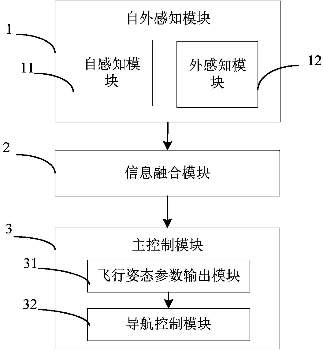
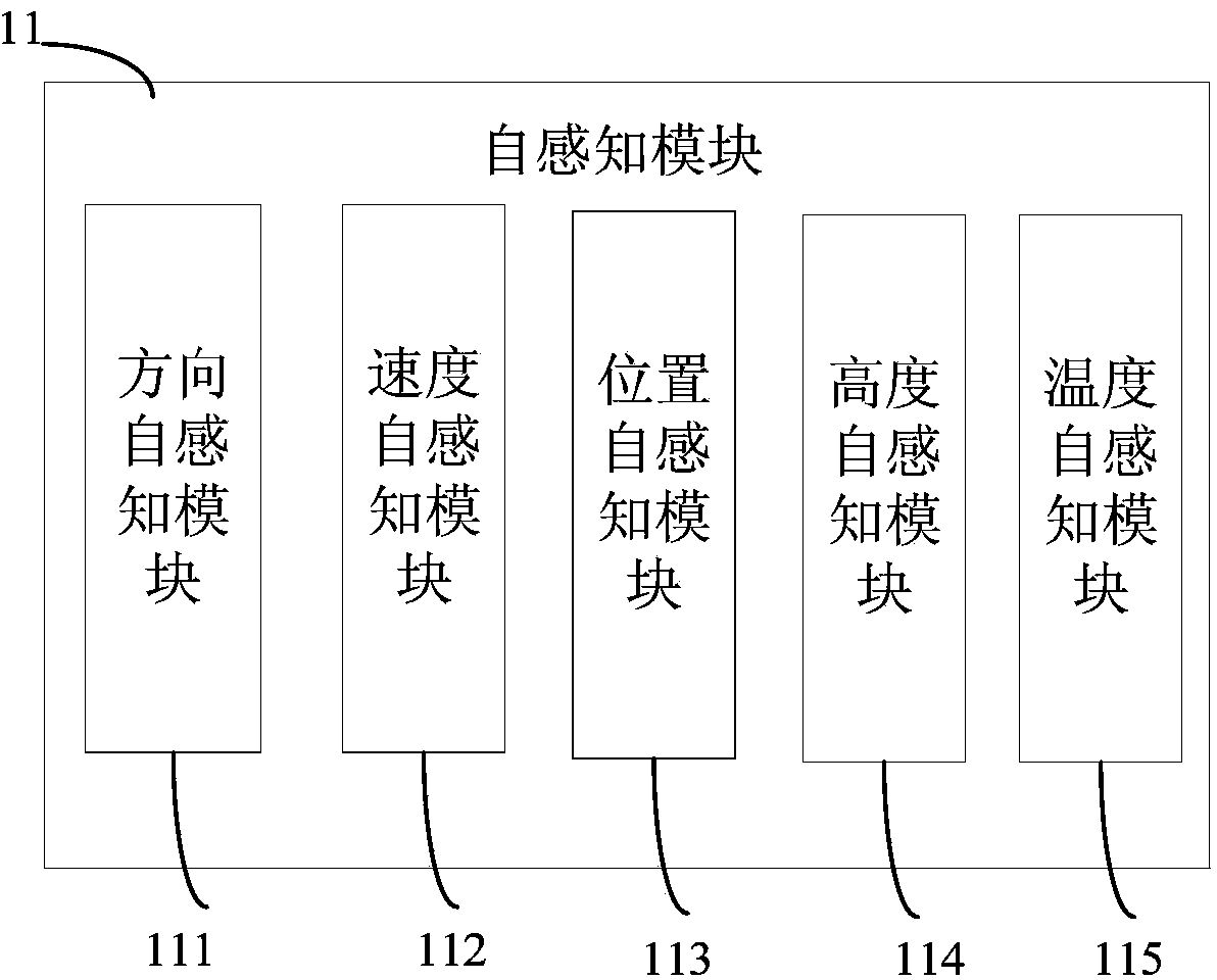
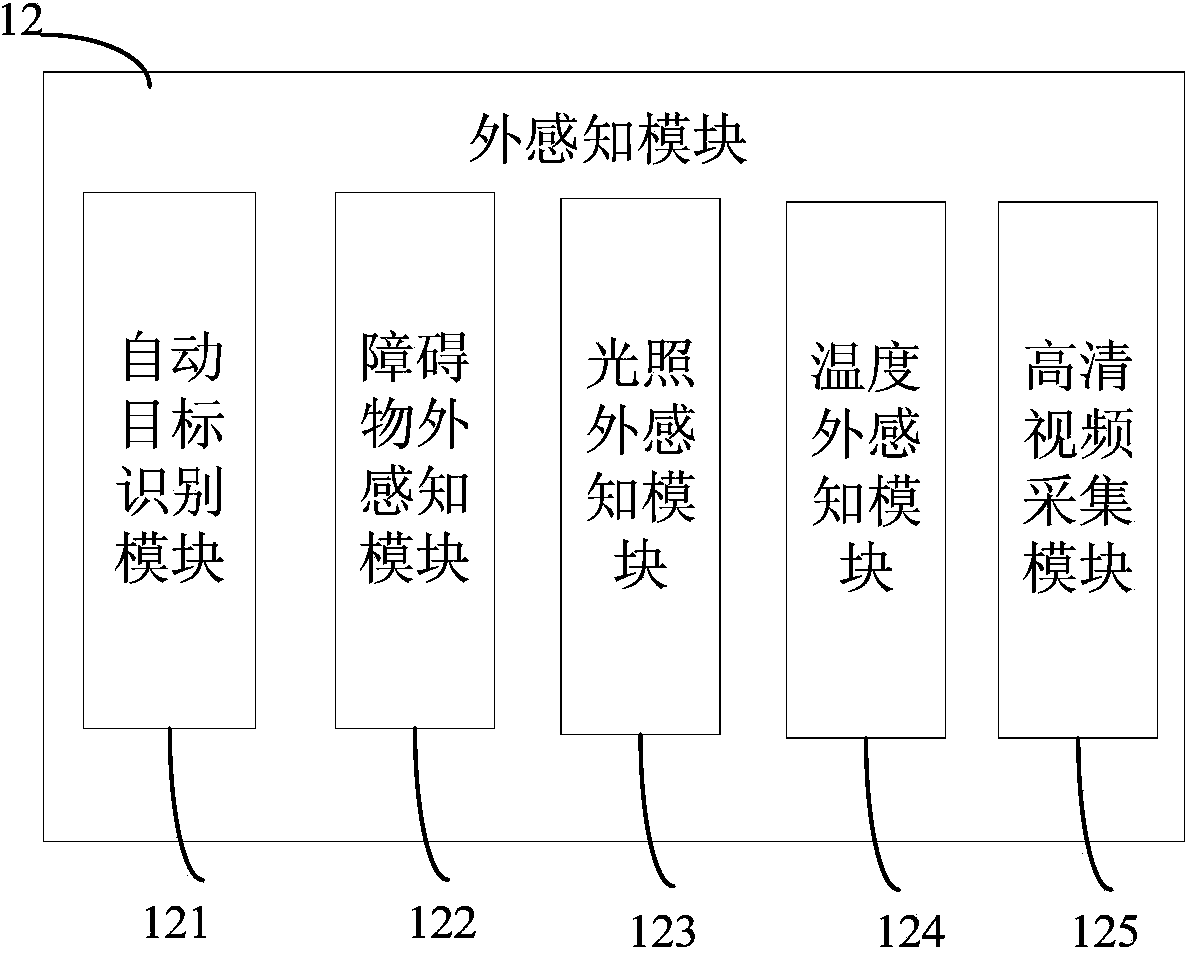
[0088] The present invention designs a high-definition video aerial multi-mode sensor self-perception intelligent navigation system, which can carry out unmanned autonomous flight through self-perception, and realize self-perception, self-adaptation, self-adjustment and self-control. The system includes self-perception subsystem, external perception subsystem, multi-sensor information fusion subsystem and main control system. Among them, the external sensing subsystem is used to obtain the internal state information of the aerial photography aircraft itself, such as the direction, flight attitude, speed, position, etc. of the aerial photography aircraft; the ex...


PUM


Abstract

The invention discloses a high-definition video aerial photography multimode sensor self-outer-sensing intelligent navigation system. The system comprises a self-outer-sensing module, an information fusion module and a master control module, wherein the sell-outer-sensing module is used for detecting and sensing the internal state and the external state of an aerial photography aircraft in real time through fusion of multiple sensors and acquiring internal state information and external state information of the aerial photography aircraft; the information fusion module is used for gathering the internal state information and the external state information of the aircraft into a decision making layer through a centralized topological structure, making a consistent decision after the information of the multiple sensors is fused in the decision making layer and outputting a navigation control signal; the master control module is used for adjusting and controlling the state of the aerial photography aircraft in real time in a three-dimensional navigation mode according to the navigation control signal, and therefore horizontal autonomous navigation and vertical autonomous navigation of the aerial photography aircraft are achieved. The invention further discloses a high-definition video aerial photography multimode sensor self-outer-sensing intelligent navigation method.

Description

technical field [0001] The invention relates to the field of a high-definition video aerial photography system, in particular to a high-definition video aerial photography multi-mode sensor sensing intelligent navigation system from the outside. Background technique [0002] With the rapid development of aerial photography technology, the market demand for aerial photography aircraft has also increased sharply. Its application scope includes long-distance aerial photography, urban security, border deployment, landform surveying and mapping, etc. With the increasing importance of national security, the application in security gradually highlights its importance. At present, the vast majority of aerial photography systems are controlled by humans. Today, the trend of intelligence is accelerating, and the control by humans will not only cause a waste of labor costs, but also greatly limit its scope of use. [0003] The intelligent navigation system is a kind of internal and ex...

Claims


Application Information

Patent Timeline
Patent Type & Authority Applications(China)
IPC IPC(8): G05D1/10
Inventor 邓超苏威积裴彦杰林秀春肖鹏钟松延黄敏君董一伯杜丽张力刘攀孟飞董博赵薇牛坤张健刘雨睿王东东张春杰黄传鹤
Owner BEIJING INST OF COMP TECH & APPL
Why Eureka
Try Eureka