Downhole drilling azimuth measurement system and measurement method

A measurement system and azimuth angle technology, applied in the direction of buildings, etc., can solve the problems of large measurement error, large factor influence, large reading error, etc., and achieve the effect of easy operation, little influence of human factors, and reduced adjustment difficulty

Active Publication Date: 2016-10-19
CHINA COAL TECH & ENG GRP CHONGQING RES INST CO LTD
View PDF8 Cites 0 Cited by
  • Summary
  • Abstract
  • Description
  • Claims
  • Application Information

AI Technical Summary

Problems solved by technology

[0003] In the prior art, the common methods for measuring the angle between the projection of the horizontal plane of the drilling pipe and the projection of the centerline of the roadway on the horizontal plane mainly include the following: one is the hanging wire method, which is the most primitive purely manual method , the tools are protractors, gradient gauges, and several cotton threads. This method is complex to operate, has large reading errors, and is considered to be greatly influenced by factors. However, because an effective, reliable, and convenient measurement method has not yet been developed, this measurement method is still in use; The other is the geological compass method. The common geomagnetic compass on the ground is used underground. Since there are many ferromagnetic substances in the underground tunnel, especially near the drilling rig, the drill pipe itself is also magnetic, which will greatly interfere with the compass. Therefore, the measurement error of this method is extremely large; there is also a manual laser marking method: using the characteristics of small laser divergence, move the center line of the roadway in parallel to the vicinity of the drilling rod, and then manually move the mechanical arm to align with the reference laser , the angle to be measured can be obtained by measuring the rotation angle of the mechanical arm. The operation of this measurement method and the equipment used is still relatively complicated, and it is accompanied by a manual alignment process, but the influence of human factors will bring large human errors.

Method used


Image

  • Downhole drilling azimuth measurement system and measurement method
  • Downhole drilling azimuth measurement system and measurement method
  • Downhole drilling azimuth measurement system and measurement method

Examples


Embodiment Construction

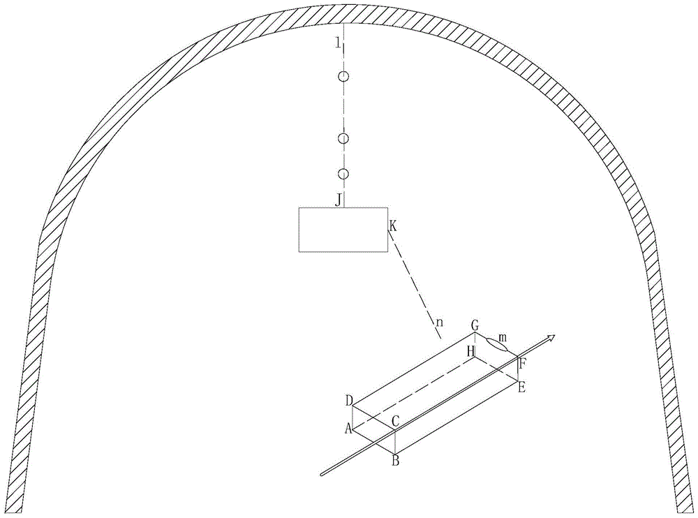
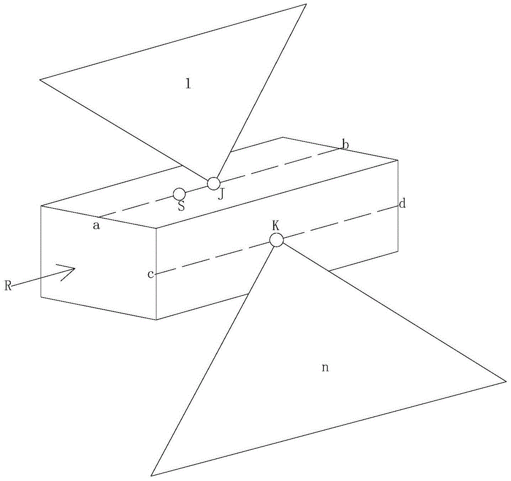
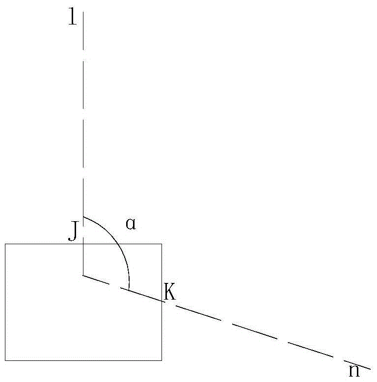
[0049] As shown in the figure: the downhole drilling azimuth measurement system of this embodiment includes a marker 1 and a measurement host 2; the marker 1 includes a line light source for generating a first exit plane 1 that coincides with the centerline of the roadway The emission device I3 and the line source emission device II4 for generating the second exit plane n intersecting the measurement host 2, the projection of the extended intersection line of the first exit plane l and the second exit plane n and the centerline of the roadway on the horizontal plane parallel to each other, the angle between the first exit plane l and the second exit plane n can be adjusted; the measuring host 2 includes an upper photosensitive plane and a side photosensitive plane for intersecting with the second exit plane n, the upper photosensitive plane and the side photosensitive plane The intersecting lines form the azimuth and inclination angles that can be consistent with the setting ax...


PUM


Abstract

The invention discloses an underground hole drilling and trepanning azimuthal angle measurement system and method. The system comprises a line marking device and a measurement host. Two line light source emitting devices on the line marking device generate two emitting planes, the first emitting plane is used for being aligned to a center line of a roadway, the second emitting plane intersects with a light sensing face on the measurement host to form a sensing straight line, the included angle between the light sensing straight line and a set shaft of the measurement host and a self inclination angle are measured thorough a processing system inside the measurement host, and therefore the hole drilling and trepanning azimuthal angle is calculated. The line marking device can be arranged according to drill sites, is installed at a time and used repeatedly, does not need to be moved and adjusted frequently, does not need to be manually operated after being installed and fixed, and can achieve continuous real-time measurement which cannot be achieved through various original examination methods. Due to the fact that the projection of the central line of the roadway on the horizontal plane is horizontally moved to the position easy to utilize, the hole drilling azimuthal angle can be more rapidly and visually measured.

Description

technical field [0001] The invention relates to the field of downhole drilling operations, in particular to a downhole drilling azimuth measurement system and a measurement method. Background technique [0002] When drilling downhole, it is often necessary to precisely design the drilling direction of the borehole. There are three main parameters for downhole drilling: drilling azimuth, drilling inclination and drilling depth. During construction, the drilling rig is placed inside the roadway and drills to the side wall. It is directly measured by the measuring instrument, but the drilling azimuth is difficult to measure directly. It is usually expressed by the angle with the center line of the roadway. The angle with the center line of the roadway is specifically: the projection of the horizontal plane of the drill pipe (or the straight line of the hole) The angle between the projection of the centerline of the roadway on the horizontal plane, where the drill pipe for open...

Claims


Application Information

Patent Timeline
Patent Type & Authority Patents(China)
IPC IPC(8): E21B47/0232
Inventor 吴银成樊荣于庆刘京威
Owner CHINA COAL TECH & ENG GRP CHONGQING RES INST CO LTD
Why Eureka
Try Eureka