
Method for automatically extracting and locating power line based on unmanned aerial vehicle image

An automatic extraction and positioning method technology, which is applied in image analysis, image data processing, computer components, etc., can solve the problems of high cost, low efficiency, and poor accuracy of power line inspection

Active Publication Date: 2014-10-08
SHENZHEN POWER SUPPLY BUREAU +1
View PDF3 Cites 29 Cited by
  • Summary
  • Abstract
  • Description
  • Claims
  • Application Information

AI Technical Summary

Problems solved by technology

[0019] The purpose of the present invention is to solve the problems of high cost, poor precision and low efficiency of power line inspection at the current stage, and propose a method of using UAVs for dual-lane flight and an accurate extraction method of aerial image power lines based on LSD and Hough

Method used


Image

  • Method for automatically extracting and locating power line based on unmanned aerial vehicle image
  • Method for automatically extracting and locating power line based on unmanned aerial vehicle image
  • Method for automatically extracting and locating power line based on unmanned aerial vehicle image

Examples


Embodiment Construction

[0043] The present invention will be further described in detail below in conjunction with the accompanying drawings and embodiments.

[0044] The embodiment of the present invention comprises three steps:

[0045] Step 1, use the UAV to carry out dual-lane flight:

[0046] The use of helicopters to conduct single-track line inspection will make the wire parallel to the epipolar line, which is not conducive to the precise positioning of the same-name point. In order to improve the accuracy, the double flight belt flight mode is adopted in the present invention.

[0047]The double-strip method can obtain images on both sides of the power line. The epipolar line of the power line point on the image is approximately perpendicular to the conductor, and since the images used for matching are taken on both sides of the conductor, the length of the baseline is sufficient. By using this method, the homonym points can be found more accurately. However, the biggest problem of using m...


PUM


Abstract

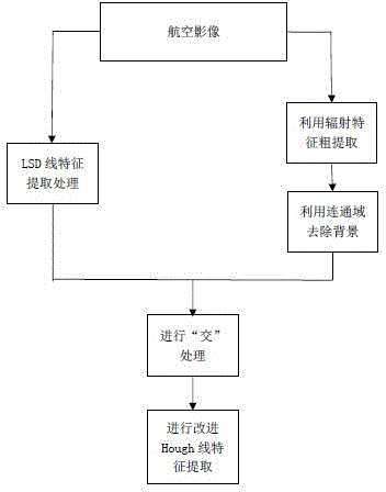
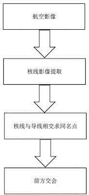
Disclosed is a method for automatically extracting and locating power lines based on an unmanned aerial vehicle image. The method comprises the steps that an unmanned aerial vehicle is used for double-air-strip flight to obtain an aerial image; the power lines of the aerial image are automatically extracted, and the aerial image is extracted through an LSD linear detection method; rough extraction is carried out through radiation features of the power lines, and background information is eliminated through connectivity; the background information with an LSD detection image removed is united, the remaining background information is eliminated, and meanwhile the detected power lines are connected; three-dimensional data of the power lines of the aerial image are located to carry out epipolar line image extraction, epipolar lines and wires intersect with one another to solve homonymy point coordinates, the forward intersection is carried out, and the three-dimensional data of the power lines are obtained. The efficiency of a three-dimensional line patrol system is improved, more precise three-dimensional coordinates are obtained, and the cost for power line corridor line patrol is lowered.

Description

technical field [0001] The invention belongs to the technical field of photogrammetry and remote sensing, and in particular relates to a power line automatic extraction and positioning method based on drone images. Background technique [0002] In order to adapt to the rapid development of the national economy, the country has accelerated the construction of the power network. However, due to the long distance and large range of power lines, and they are often erected in places far away from residential areas, it has brought huge difficulties to the safety and maintenance of power infrastructure such as transmission networks. [0003] For a long time, the inspection and maintenance of transmission lines mainly rely on manual field exploration with low efficiency, high cost and poor safety. Every year, the State Grid invests a lot of human, material and financial resources in manual inspection, which is labor-intensive, low-efficiency, and difficult working conditions. Beca...

Claims


Application Information

Patent Timeline
Patent Type & Authority Applications(China)
IPC IPC(8): G06K9/60G06K9/46G06T7/00
Inventor 裴慧坤周伟才江克宜谭波魏前虎申作家张金广杨进科周海峰黄浩周云黄海鹏杨斌林乐赵义南朱敏杰江万寿杨成城杨亮
Owner SHENZHEN POWER SUPPLY BUREAU
Learn More