Method for inversion of ground feature high elevation and number of land subsidence through high resolution InSAR timing sequence analysis

A high-resolution, time-series analysis technology, applied in measurement devices, radio wave measurement systems, radio wave reflection/re-radiation, etc.

Inactive Publication Date: 2014-10-29
CHINA AERO GEOPHYSICAL SURVEY & REMOTE SENSING CENT FOR LAND & RESOURCES
View PDF6 Cites 42 Cited by
  • Summary
  • Abstract
  • Description
  • Claims
  • Application Information

AI Technical Summary

Problems solved by technology

However, such high-resolution DEM data are often difficult to obtain
Therefore, this method of compensating the elevation of the entire pixel through an external DEM (such as SRTM) will be difficult to apply in high-resolution data processing, and it is necessary to study the method of accurate calculation of the elevation of a single object

Method used


Image

  • Method for inversion of ground feature high elevation and number of land subsidence through high resolution InSAR timing sequence analysis
  • Method for inversion of ground feature high elevation and number of land subsidence through high resolution InSAR timing sequence analysis
  • Method for inversion of ground feature high elevation and number of land subsidence through high resolution InSAR timing sequence analysis

Examples


Embodiment Construction

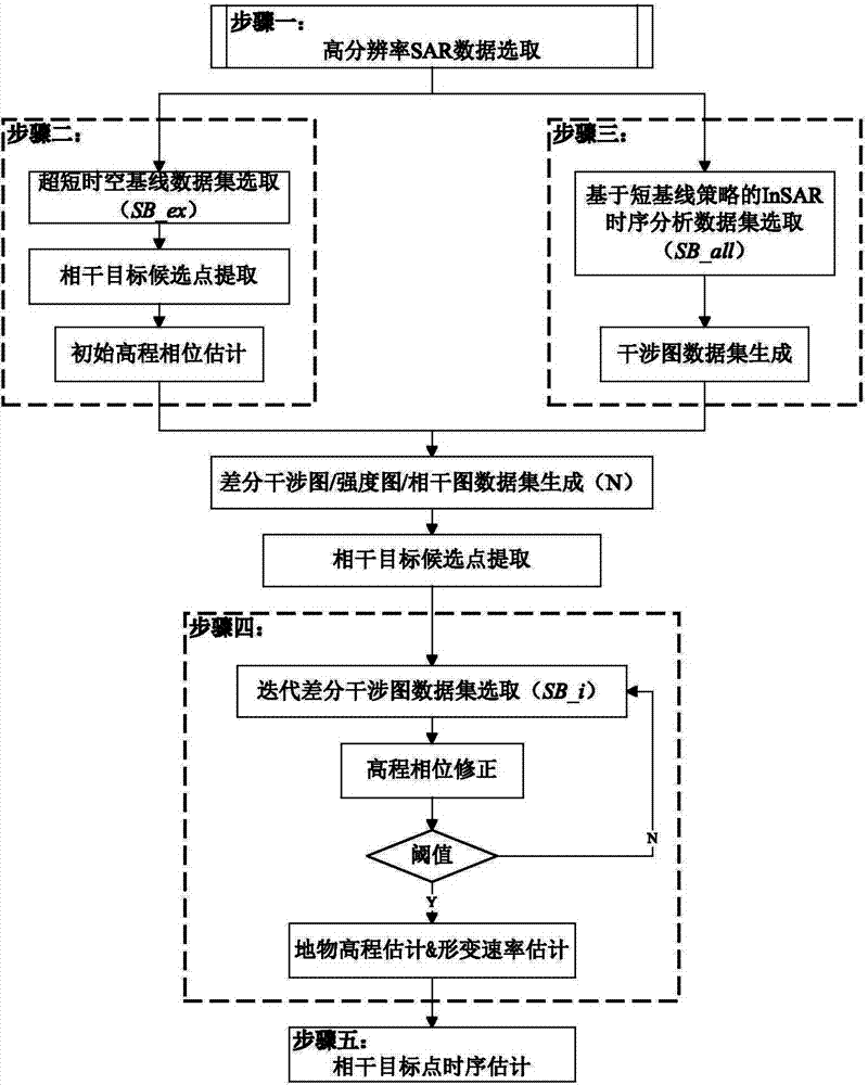
[0071] Taking Cosmo-skymed InSAR to monitor land subsidence in Lujiazui area of ​​Shanghai as an example, the specific operation steps of the present invention in actual engineering application are illustrated. like image 3 As shown, the present invention is a method for high-resolution InSAR time-series analysis and inversion of ground object elevation and ground subsidence. The specific steps of the method are as follows:

[0072] Step 1: High-resolution SAR data selection

[0073] The Cosmo-skymed 3m resolution radar data covering the main urban area of ​​Shanghai was selected. The acquisition time was from December 2008 to June 2010, the time span was one and a half years, and the number of data sets was 35 scenes. The Cosmo-skymed system is a constellation of four radar satellites jointly funded by the Italian Ministry of Defense and the Space Agency and developed by Alenia Space. Its 3-meter resolution data width is 40km×40km, the azimuth and range bandwidths are 3100...


PUM


Abstract

A method for inversion of the ground feature high elevation and the number of land subsidence through high resolution InSAR timing sequence analysis includes the first step of high resolution SAR data selection, the second step of initial elevation phase estimation, the third step of selection of InSAR timing sequences, analysis of an interference image pair data set and extraction of coherent target candidate points, the fourth step of elevation phase correction and linear deformation component estimation, and the fifth step of deformation sequence estimation of coherent targets. According to the method, the defect that no high resolution DEM is available for removal of high-rise building additional phases in urban area high resolution InSAR deformation monitoring data processing can be overcome, the additional phases and deformation phases of urban high-rise buildings in the high resolution InSAR are effectively separated, and therefore monitoring precision of the high resolution InSAR in urban area land subsidence is greatly improved.

Description

technical field [0001] The invention relates to a method for high-resolution InSAR time series analysis and inversion of surface object elevation and ground subsidence, and belongs to the field of synthetic aperture radar interferometry (InSAR). It can effectively separate the additional phase and deformation phase of urban high-rise buildings in the high-resolution InSAR interferogram, which can greatly improve the monitoring accuracy of high-resolution InSAR in urban land subsidence. Background technique [0002] Using InSAR to solve the elevation (DEM) or deformation variable, phase unwrapping is one of the necessary steps. This step is called unwrapping in differential interference processing, and it is called parameter estimation in time series analysis method. Its essence is to solve The whole number of phase wrapping, the basic process is to solve the phase difference between adjacent points, and then integrate according to a specific path or network with certain cons...

Claims


Application Information

Patent Timeline
Patent Type & Authority Applications(China)
IPC IPC(8): G06F19/00G01S13/90
Inventor 葛大庆王艳刘斌张玲李曼郭小方
Owner CHINA AERO GEOPHYSICAL SURVEY & REMOTE SENSING CENT FOR LAND & RESOURCES
Why Eureka
Try Eureka