Automatic navigating impeding analyzing method and system based on fairway depth data

A technology of water depth and waterway, applied in the direction of electrical digital data processing, special data processing applications, instruments, etc., can solve the problems of heavy workload, time-consuming updating, low work efficiency, etc., achieve fast and accurate extraction, and improve the efficiency of navigational analysis The accuracy of the analysis results and the intuitive effect of the analysis process

Inactive Publication Date: 2014-12-10
WUHAN UNIV
View PDF3 Cites 11 Cited by
  • Summary
  • Abstract
  • Description
  • Claims
  • Application Information

AI Technical Summary

Problems solved by technology

The traditional navigation analysis method requires more manual participation and heavy workload. It takes a long time to complete the navigation analysis task cycle of a navigation topographic map, and the work efficiency is low; it is difficult to modify the data, and the update is more time-consuming and laborious; without the computer visualization process, the entire The analysis process is not intuitive enough; the accuracy of the obstruction analysis results is low

Method used


Image

  • Automatic navigating impeding analyzing method and system based on fairway depth data
  • Automatic navigating impeding analyzing method and system based on fairway depth data
  • Automatic navigating impeding analyzing method and system based on fairway depth data

Examples


Embodiment Construction

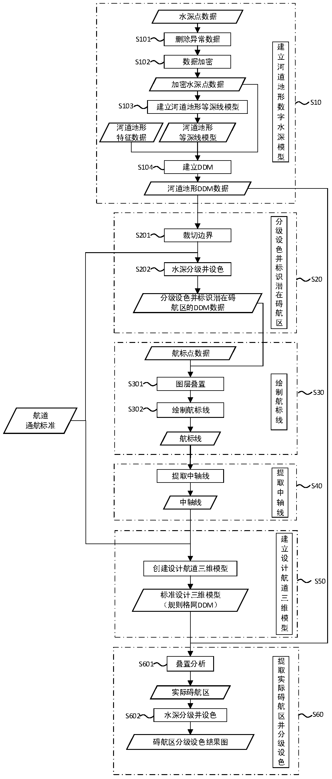
[0055] The navigation obstruction analysis automation method based on channel water depth data of the present invention focuses on extracting the navigation obstruction area automation process of the navigation channel, and realizes the navigation obstruction analysis by digitally modeling the digital channel terrain data, using computer interaction technology and geographic visualization technology to calculate the navigation obstruction area automation.

[0056] In order to make the object, technical solution and advantages of the present invention clearer, the present invention will be described in detail below in conjunction with the accompanying drawings and embodiments.

[0057] The data sources required by the present invention are waterway topographic data and waterway standard data: waterway topographic map data include waterway water depth point data, waterway characteristic data, and navigation mark data; waterway standard data include waterway minimum navigable wate...


PUM


Abstract

The invention provides an automatic navigating impeding analyzing method and system based on fairway depth data. The method comprises the steps that a terrain modeling method based on regular grids is utilized for establishing a riverway terrain digital water depth model; the water depths are graded and colored, and potential navigating impeding areas are marked; navigation mark lines are drawn; a fairway central axis is extracted; a terrain three-dimensional modeling method based on the regular grids is utilized for designing and establishing a fairway three-dimensional model according to the fairway central axis, the standard fairway width and the fairway maintaining navigable water level; the actual navigating impeding areas are extracted, graded and colored. According to the automatic navigating impeding analyzing method and system, digital modeling is carried out on the fairway terrain based on the digital modeling technology, automatic extraction of the fairway navigating impeding areas is achieved based on the technologies such as geography visualization, computers and three-dimensional space analyzing according to the fairway navigating impeding analyzing process, and the navigating impeding analyzing efficiency and the precision of the navigating impeding analyzing result are improved.

Description

[0001] technical field [0002] The invention relates to the technical field of digital waterways, in particular to an automatic navigation obstruction analysis method and system based on water depth data of the waterway. Background technique [0003] Navigational obstruction analysis is an important process in channel improvement projects. According to the requirements of channel navigation standards, the actual navigational obstruction area of ​​the channel is extracted by separating the area in the channel where the water depth is less than the water depth of the channel maintenance navigable water level and the area where the water depth is greater than or equal to the water channel maintenance navigable water level. The navigable area refers to the area where the water depth in the channel is less than the water depth of the channel maintenance navigable water level. It is an area where ships cannot navigate normally. It not only affects the safety of navigation, limits ...

Claims


Application Information

Patent Timeline
Patent Type & Authority Applications(China)
IPC IPC(8): G06F17/50
Inventor 蔡忠亮张玲高凯春殷红范黎明蒋子捷刘天云伍文俊谢彩云宋忱忱陈轩
Owner WUHAN UNIV
Why Eureka
Try Eureka