Land surface temperature inversion method based on spatio-temporal information of paired HJ-1B images

A HJ-1B, surface temperature technology, applied in the field of thermal infrared remote sensing, can solve the problems of ineffective implementation, inability to accurately obtain surface emissivity and atmospheric parameters, and achieve the effect of overcoming dependence on auxiliary information and promoting quantitative applications.

Inactive Publication Date: 2014-12-24
INST OF URBAN ENVIRONMENT CHINESE ACAD OF SCI
View PDF4 Cites 9 Cited by
  • Summary
  • Abstract
  • Description
  • Claims
  • Application Information

AI Technical Summary

Problems solved by technology

[0005]Technical problems to be solved The main technical problems to be solved by the present invention are: when the surface emissivity and atmospheric parameters (such as atmospheric moisture content, atmospheric average In the case of the effect temperature), that is, when the existing single-window (or single-channel) algorithm cannot be effectively implemented, the accurate inversion of the surface temperature from the HJ-1B image can be realized

Method used


Image

  • Land surface temperature inversion method based on spatio-temporal information of paired HJ-1B images
  • Land surface temperature inversion method based on spatio-temporal information of paired HJ-1B images
  • Land surface temperature inversion method based on spatio-temporal information of paired HJ-1B images

Examples


Embodiment Construction

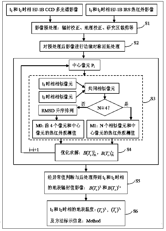
[0016] The land surface temperature retrieval method based on the paired HJ-1B image spatio-temporal information provided by the present invention will be described in detail below with reference to the accompanying drawings and specific embodiments. The following examples are only used to illustrate the present invention, but not to limit the scope of the present invention. Such as figure 1 As shown, the present invention is based on the land surface temperature inversion method of paired HJ-1B image space-time information, which mainly includes the following steps:

[0017] S1 Obtain the image of the study area, and perform radiometric correction, geocorrection, resampling and cropping preprocessing

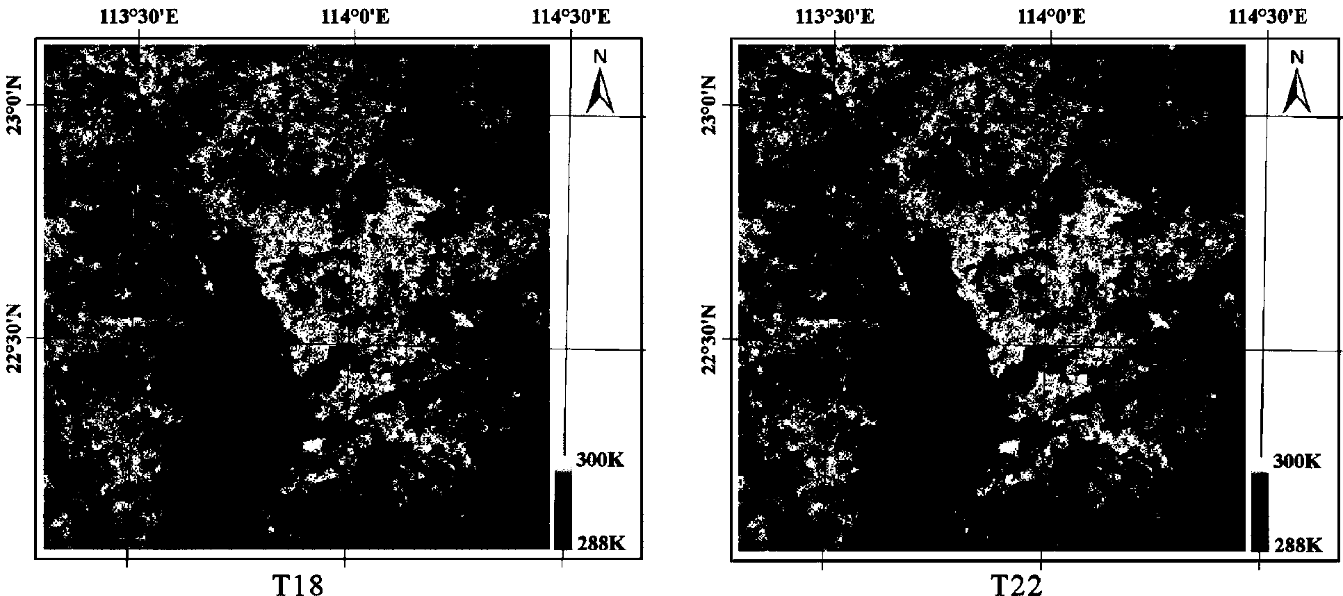
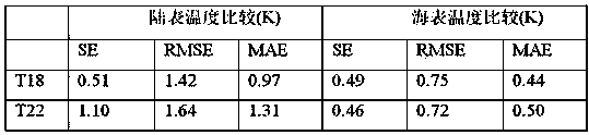
[0018] In this embodiment, two scenes of HJ-1B IRS images with similar time phases are acquired (the acquisition time phases are December 18, 2011 and December 22, 2011 (path / row: 452 / 91), respectively recorded in the following are time phases T18 and T22), and the m...


PUM


Abstract

The invention discloses a land surface temperature inversion method based on spatio-temporal information of paired HJ-1B images. The method is a new strategy for solving the problem that in application of an existing mono-window algorithm or a single-channel algorithm, parameters are difficult to obtain. The method comprises the implementation steps that, S1, the HJ-1B images of two paired time phases in a research area are obtained and preprocessed; S2, the preprocessed images are processed symmetrically in a boundary extension; S3, similar pixels are recognized, the number of the pixels is obtained, and the corresponding inversion method is determined; S4, according to the judgment result of S3, a radiation transfer equation set is built, and the land surface radiation value is worked out; S5, S3 and S4 are circularly carried out, the land surface radiation values of the whole research area in the two time phases are obtained, and abnormal value recognition and processing are carried out; S6, the land surface temperature is obtained through inversion according to the processed land surface radiation values. According to the land surface temperature inversion method based on spatio-temporal information of the paired HJ-1B images, the land surface temperature can be accurately obtained through inversion under the situation that relative parameters cannot be accurately obtained, and quantitative application of HJ-1B thermal infrared data can be effectively promoted.

Description

technical field [0001] The present invention relates to the technical field of thermal infrared remote sensing, and more specifically, when the specific emissivity of the surface and the atmospheric parameters are unknown, using the time-space information of two paired time-phase HJ-1B images, the radiance of a single thermal infrared band A method for direct quantitative inversion of land surface temperature. Background technique [0002] Surface temperature is one of the key factors affecting ecosystems, and it is related to many surface processes. Thermal infrared satellite remote sensing technology is considered to be a feasible and effective means to obtain regional and global scale land surface temperature information at this stage. In order to accurately extract surface temperature information from thermal infrared satellite remote sensing images, researchers at home and abroad have proposed a series of inversion methods, such as single-window (or single-channel) alg...

Claims


Application Information

Patent Timeline
Patent Type & Authority Applications(China)
IPC IPC(8): G01J5/00
Inventor 陈峰赵小锋全元
Owner INST OF URBAN ENVIRONMENT CHINESE ACAD OF SCI
Why Eureka
Try Eureka