Low-altitude flight control method applied to airborne geophysical prospecting of unmanned aerial vehicle

A technology of low-altitude flight and aerial geophysical exploration, applied in the direction of using feedback control, etc., can solve the problem of high safety, and achieve the effect of improving safety and avoiding obstacles.

Active Publication Date: 2014-12-24
CHINA ACAD OF AEROSPACE AERODYNAMICS
View PDF4 Cites 26 Cited by
  • Summary
  • Abstract
  • Description
  • Claims
  • Application Information

AI Technical Summary

Problems solved by technology

[0004] The problem solved by the technology of the present invention is: in the field of aerial geophysical prospecting, in order to obtain a good geological and mineral detection effect, the aerial geophysical prospecting method requires that the flight height of the aircraft is very low, the flight is stable, and the fluctuation is small. The low-altitude flight control method can carry out effective aeronautical geophysical flight operations on hilly terrain and small-slope mountainous terrain, so that the UAV can fly along the terrain at ultra-low altitude and track the terrain better, effectively avoiding obstacles , high security

Method used


Image

  • Low-altitude flight control method applied to airborne geophysical prospecting of unmanned aerial vehicle
  • Low-altitude flight control method applied to airborne geophysical prospecting of unmanned aerial vehicle
  • Low-altitude flight control method applied to airborne geophysical prospecting of unmanned aerial vehicle

Examples


Embodiment Construction

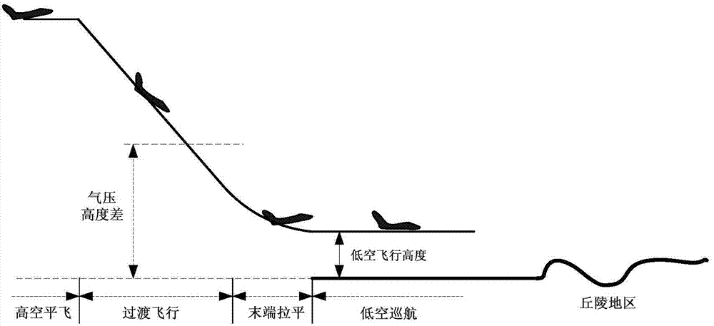
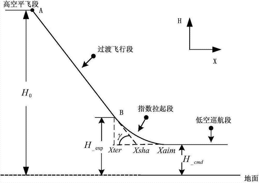
[0021] The main difference between the low-altitude cruising flight of the UAV and the conventional route flight is that when it is cut into the low-altitude cruising flight, the environment of the UAV flight will change greatly, and the control of the aircraft is relatively complicated. The processes related to low-altitude cruise flight can be divided into: low-altitude cruise cut-in segment, low-altitude cruise segment, and low-altitude cruise segment. The UAV first needs to track a given glide trajectory, fly along the trajectory profile to the vicinity of a given low-altitude cruising height range, and enter low-altitude cruising; Pull up with the flight altitude and leave the low-altitude cruising area.

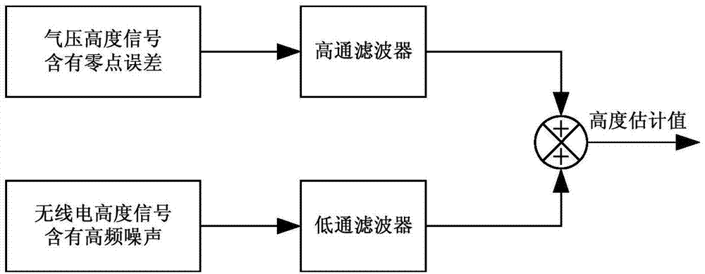
[0022] The UAV altitude source has a total of three sensor measurement outputs: air data machine, radio altimeter and GPS. When flying at low altitude, the UAV adopts barometric altitude and radio altitude complementary filtering to obtain an altitude signal with a high...


PUM


Abstract

The invention discloses a low-altitude flight control method applied to airborne geophysical prospecting of an unmanned aerial vehicle. The low-altitude flight control method includes adopting complementary filter of pressure altitude and radio altitude of the unmanned aerial vehicle to obtain altitude signals with high signal to noise ratio as a low-altitude flight height control source of the unmanned aerial vehicle. High-frequency topographic influence can be filtered by flight altitude, terrain can be well tracked, and airborne geophysical prospecting flight operation can be realized effectively in hills and small-gradient mountainous areas, so that the unmanned aerial vehicle can fly at minimum altitude along topographic relief, track the terrain and effectively avoid obstacles and is capable of acquiring high-quality exploration data of an airborne geophysical prospecting operation aeromagnetic system and an airborne radioactive system, and geophysical prospecting safety is improved. Feasibility of the low-altitude flight control method is verified by practical tests, is completely succeeded and has pilot application effect for relevant flight control methods and creates basis for massive airborne geophysical prospecting application in the unmanned aerial vehicle.

Description

technical field [0001] The invention relates to a low-altitude flight control method, in particular to a low-altitude flight control method applied to aerial geophysical exploration of unmanned aerial vehicles, and belongs to the field of aerial geophysical exploration of unmanned aerial vehicles. Background technique [0002] At present, airborne geophysical prospecting (airborne geophysical prospecting, is a kind of geophysical prospecting method. It is a method of studying and searching for underground geological structures and minerals by detecting changes in various geophysical fields during navigation through special geophysical prospecting instruments equipped on aircraft. A geophysical prospecting method.) With manned aircraft as the main carrier, problems are becoming increasingly prominent while achieving gratifying results, and unmanned aerial vehicle has become an effective way to solve related problems to a large extent. First, there is a high risk of manned air...

Claims


Application Information

Patent Timeline
Patent Type & Authority Applications(China)
IPC IPC(8): G05D3/12
Inventor 蔡永恒郝治国张新伟
Owner CHINA ACAD OF AEROSPACE AERODYNAMICS
Why Eureka
Try Eureka