
Satellite-borne SAR (Synthetic Aperture Radar) based offshore wind energy resource remote sensing method and system

A wind energy and resource technology, applied in the field of remote sensing of offshore wind energy resources based on space-borne SAR, can solve unfavorable wind farm fan layout, inaccurate microscopic analysis of wind energy resources, and inability to obtain spatial quantitative change characteristic data of fine structure changes of wind energy resources and other issues to achieve an effect that is conducive to a reasonable layout

Inactive Publication Date: 2015-01-07
HUBEI UNIV
View PDF2 Cites 11 Cited by
  • Summary
  • Abstract
  • Description
  • Claims
  • Application Information

AI Technical Summary

Problems solved by technology

[0006] The existing SAR image-based remote sensing technology for wind energy resources only studies the macroscopic spatiotemporal and spatial characteristics of offshore wind energy resources, and only gives some qualitative descriptions of the wind field characteristics in the wake area of ​​wind turbines. The microstructure changes of regional wind energy resources and the spatial quantitative change characteristic data of small-scale wind fields in the wake area of ​​wind turbines provide relevant technical parameters for the spatial layout of wind turbines for potential wind farms. Therefore, the microscopic analysis of wind energy resources is not accurate and is not conducive to wind power generation. Field fan layout

Method used


Image

  • Satellite-borne SAR (Synthetic Aperture Radar) based offshore wind energy resource remote sensing method and system
  • Satellite-borne SAR (Synthetic Aperture Radar) based offshore wind energy resource remote sensing method and system
  • Satellite-borne SAR (Synthetic Aperture Radar) based offshore wind energy resource remote sensing method and system

Examples


Embodiment Construction

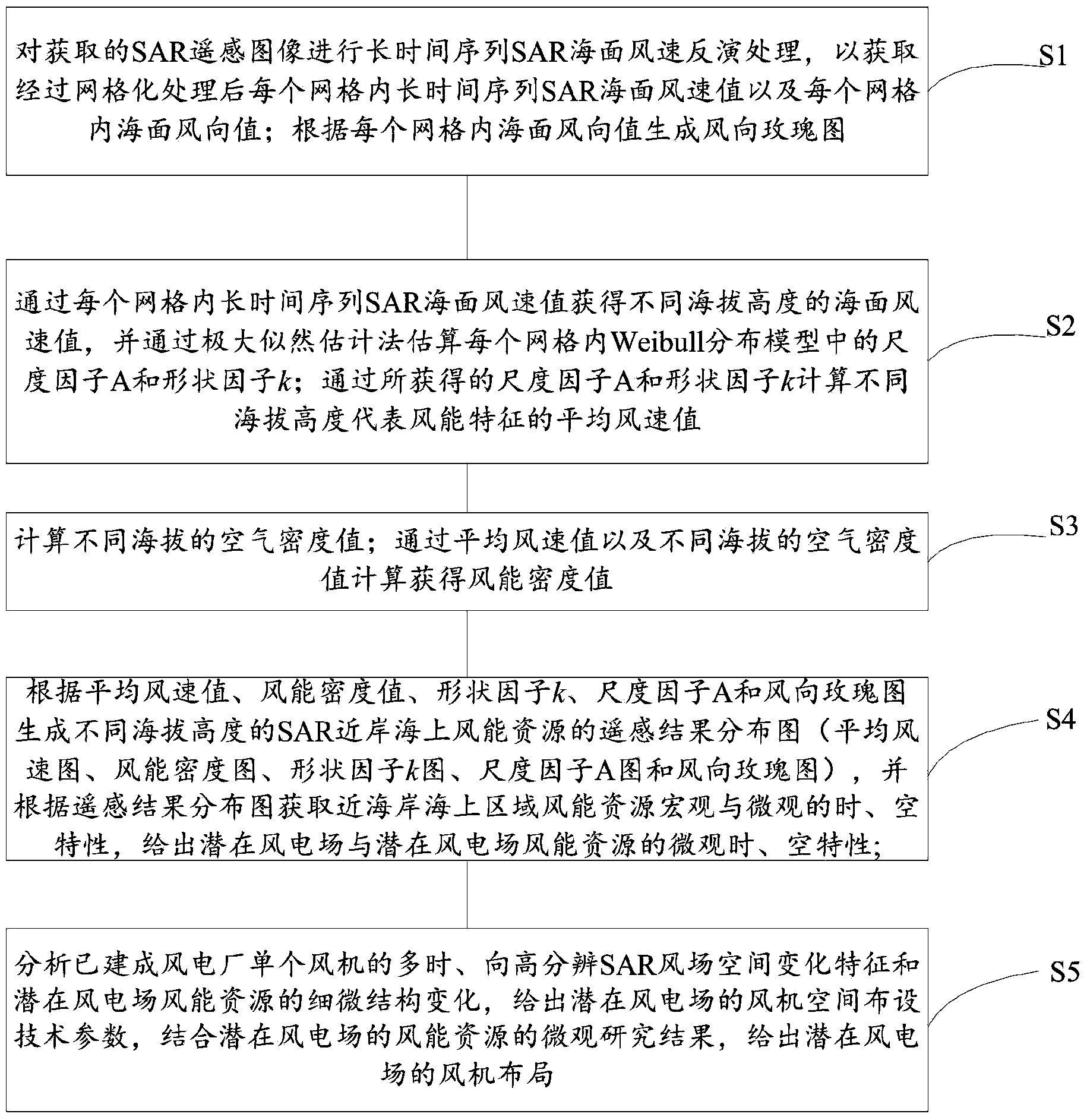
[0024] Such as figure 1 As shown, the embodiment of the present invention provides a remote sensing method for offshore wind energy resources based on spaceborne SAR, which includes the following steps:

[0025] S1. Perform long-term sequence SAR sea surface wind speed inversion processing on the acquired SAR remote sensing images to obtain long-time sequence SAR sea surface wind speed values ​​in each grid and sea surface wind direction values ​​in each grid after grid processing. A wind rose diagram is generated according to the sea surface wind direction value in each grid.

[0026] Wind direction rose diagram (referred to as wind rose diagram) is also called wind direction frequency rose diagram. It is based on the percentage value of each wind direction and wind speed in a certain area for many years, and is drawn in a certain proportion. Generally, it is represented by 8 or 16 compass positions. .

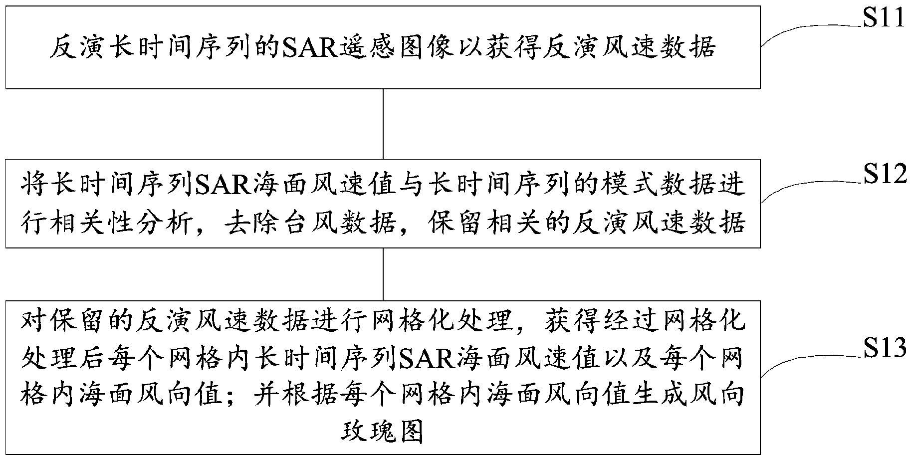
[0027] Optionally, as in figure 2 As shown, the step S1 includes the...


PUM


Abstract

The invention provides a satellite-borne SAR (Synthetic Aperture Radar) based offshore wind energy resource remote sensing method. The satellite-borne SAR based offshore wind energy resource remote sensing method comprises step 1, obtaining a long time sequence SAR sea surface wind speed value in every grid and a sea surface wind direction value in every grid after grid processing and generating a wind rose diagram; step 2, obtaining different altitudes of sea surface wind speed values, estimating a scale factor A and a shape factor k in every grid and calculating an average wind speed value of different altitudes of representative wind energy characteristics; step 3, obtaining a wind energy density value; step 4, generating a remote sensing result distribution diagram of the different altitudes of SAR offshore wind energy resources, obtaining the macroscopic and microscopic time and space characteristics of the offshore area wind energy resources according to the remote sensing result distribution diagram and giving out the microscopic time and space characteristics of a potential wind power station and potential wind power station wind energy resources; step 5, giving out fan space layout parameters of the potential wind power station and combining with a microcosmic research result of the win energy resources of the potential wind power station to give out the fan layout of the potential wind power station.

Description

technical field [0001] The invention relates to the technical field of remote sensing of wind energy resources, in particular to a method and system for remote sensing of offshore wind energy resources based on spaceborne SAR. Background technique [0002] Offshore offshore wind energy resources do not occupy land resources, have a large space for location selection, are conducive to site selection, are less restricted by the environment, have higher wind speeds, more abundant wind energy resources, superior transportation and hoisting conditions, and larger single-machine capacity of wind turbines. Countries around the world are developing their own offshore wind power industries one after another due to the advantages of higher annual utilization hours. [0003] The development of offshore wind energy resources near the coast must first understand the location, storage and coverage area of ​​available wind energy resources, and the preliminary construction of wind farms ne...

Claims


Application Information

Patent Timeline
IPC IPC(8): G06F19/00G01S13/90
Inventor 范开国于兴修王瑶傅斌常俊芳
Owner HUBEI UNIV
Learn More