UAV-based method for monitoring landslides and debris flows in mountainous areas
A technology of landslides and unmanned aerial vehicles, applied in the direction of instruments, alarms, etc., can solve the problems of wasting time and energy for rescue, consume a lot of time, and inconvenient transportation, etc., and achieve the effect of improving rescue efficiency, safe operation and low cost of use
- Summary
- Abstract
- Description
- Claims
- Application Information
AI Technical Summary
Problems solved by technology
Method used
Image
Examples
Embodiment 1
[0024] Embodiment 1: a kind of method based on unmanned aerial vehicle monitoring mountain landslide, mud-rock flow, comprises the following several steps:
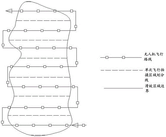
[0025] a) When a landslide or mudslide accident occurs in a mountainous area, use known information and computer technology to draw the accident area and flight route for the first flight of the UAV;
[0026] b) According to the initial flight route formulated by the computer, the UAV performs its first flight. During the flight, the UAV is equipped with imaging equipment. When it enters the estimated accident area, the imaging equipment is turned on, and the whole process of the UAV is taken with the positioning equipment. On-site mountain conditions in the flight area;
[0027] c) According to the video recorded during the first flight and the coordinates recorded by the positioning equipment, the images and data obtained by the aerial photography of the drone are imported into the 3D simulation computer for manual comp...
Embodiment 2
[0033] Example 2: During the initial flight of the UAV in step b), the UAV flies along the sideline of the planned accident area to confirm the specific scope of the accident area; if the actual area of the accident area is found in step c) If it is larger than the planned accident area, step a) needs to be re-executed;
Embodiment 3
[0034] Example 3: During the actual manual comparison in step f), when people are found to be calling for help or victims of a disaster during manual observation and comparison, cooperate with the positioning equipment carried by the drone to determine the location information of the personnel, and re-execute d )-f) steps, in the process of repeated flight, it is necessary to send rescue to the designated location for rescue.
PUM
 Abstract
Description
Claims
Application Information
 - R&D
- Intellectual Property
- Life Sciences
- Materials
- Tech Scout
- Unparalleled Data Quality
- Higher Quality Content
- 60% Fewer Hallucinations
Browse by: Latest US Patents, China's latest patents, Technical Efficacy Thesaurus, Application Domain, Technology Topic, Popular Technical Reports.
© 2025 PatSnap. All rights reserved.Legal|Privacy policy|Modern Slavery Act Transparency Statement|Sitemap|About US| Contact US: help@patsnap.com

