
Remote sensing image classification method based on active deep learning

A technology of remote sensing images and classification methods, which is applied in the field of remote sensing image classification based on active deep learning, can solve problems such as imbalanced data learning problems, and achieve the effects of reducing complexity, improving efficiency, and reducing the number of samples

Inactive Publication Date: 2015-04-01
INST OF REMOTE SENSING & DIGITAL EARTH CHINESE ACADEMY OF SCI
View PDF2 Cites 22 Cited by
  • Summary
  • Abstract
  • Description
  • Claims
  • Application Information

AI Technical Summary

Problems solved by technology

In addition, the theoretical research on active learning is helpful for us to deeply understand many important theoretical issues in machine learning, such as how to reduce sample complexity, how to deal with small sample data sets, learning problems of unbalanced data, effective use of labeled data, supervised learning and unmanned learning. The connection between supervised learning has very important guiding significance, but as far as the current situation is concerned, both supervised learning and unsupervised learning have their own shortcomings.
[0004] Therefore, it is now necessary to develop a remote sensing image classification algorithm based on active deep learning to overcome the shortcomings of using unsupervised learning and supervised learning respectively in the prior art

Method used


Image

  • Remote sensing image classification method based on active deep learning
  • Remote sensing image classification method based on active deep learning
  • Remote sensing image classification method based on active deep learning

Examples


Embodiment Construction

[0020] The following will clearly and completely describe the technical solutions in the embodiments of the present invention with reference to the accompanying drawings in the embodiments of the present invention. Obviously, the described embodiments are only some, not all, embodiments of the present invention. All other embodiments obtained by persons of ordinary skill in the art based on the embodiments of the present invention belong to the protection scope of the present invention.

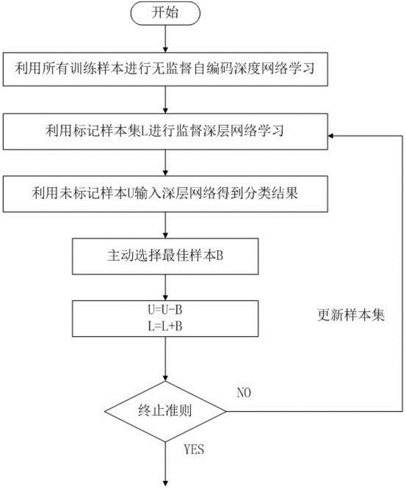
[0021] Such as figure 1 As shown, a remote sensing image classification method based on active deep learning according to an embodiment of the present invention includes the following steps:

[0022] Step 1: Select the remote sensing image data to be classified;

[0023] Step 2: Using a pre-configured algorithm to process the remote sensing image data, the specific steps include:

[0024] Step 2-1: Use all training samples of remote sensing image data for unsupervised self-encoding deep net...


PUM


Abstract

The invention discloses a remote sensing image classification method based on active deep learning. The remote sensing image classification method includes the steps that (1), remote sensing image data to be classified are selected; (2), the remote sensing image data are processed by utilizing an algorithm configured in advance; (3), the optimal sample B is selected from unmarked samples U by applying the active learning algorithm nEQB; (4), the optimal sample B is subtracted from the unmarked samples U to obtain a new unmarked sample set U', and the optimal sample B is added to marked samples L to obtain a new marked sample set L'; (5), the step (2) is executed again, the process continues to be circulated, the circulation is completed until the unmarked sample set U'is a null set or a preset learning stopping index is met, and classification accuracy and a classification result graph matched with the classification accuracy are output. The remote sensing image classification method has the advantages that through deep learning and active learning, the defects caused by using unsupervised learning and supervised learning can be overcome, and the classification accuracy of the data is effectively improved.

Description

technical field [0001] The invention relates to remote sensing image data, in particular to a remote sensing image classification method based on active deep learning. Background technique [0002] At present, for some shallow algorithms (referring to neural networks with only one hidden layer, kernel regression, support vector machines, etc.), when given a limited number of samples and computing units, it is difficult for shallow structures to effectively represent complex functions. Moreover, there are obvious deficiencies in the performance and generalization capabilities of complex classification problems, especially when the target object has rich meanings, so it has certain limitations. [0003] Deep learning emphasizes the depth of the model structure, usually with multiple layers of hidden layer nodes, which clearly highlights the importance of feature learning. Through layer-by-layer feature transformation, the feature representation of the sample in the original sp...

Claims


Application Information

Patent Timeline
IPC IPC(8): G06K9/66
CPCG06F18/2411
Inventor 王力哲左亚青刘鹏赵灵军
Owner INST OF REMOTE SENSING & DIGITAL EARTH CHINESE ACADEMY OF SCI
Learn More