Method for utilizing airborne laser radar point cloud to extract urban vegetation three-dimensional coverage map

An airborne lidar and laser point technology, which is applied in the direction of utilizing re-radiation, re-radiation of electromagnetic waves, measuring devices, etc., can solve problems such as the reduction of the surface area, and achieve the effect of improving the ecological living environment quality of urban residents

Inactive Publication Date: 2015-04-08
NANJING UNIV
View PDF3 Cites 21 Cited by
  • Summary
  • Abstract
  • Description
  • Claims
  • Application Information

AI Technical Summary

Problems solved by technology

[0005] Purpose of the invention: The present invention proposes a method for extracting three-dimensional coverage of urban vegetation by using airborne laser radar point cloud, effectively extracting three-dimensional coverage information of urban vegetation, obtaining a three-dimensional coverage map, and solving the problem of using two-dimensional images in the investigation of urban vegetation coverage to change the surface area. Small problems are conducive to the study of how to improve the quality of the ecological living environment of urban residents

Method used


Image

  • Method for utilizing airborne laser radar point cloud to extract urban vegetation three-dimensional coverage map
  • Method for utilizing airborne laser radar point cloud to extract urban vegetation three-dimensional coverage map
  • Method for utilizing airborne laser radar point cloud to extract urban vegetation three-dimensional coverage map

Examples


Embodiment Construction

[0027] Below in conjunction with accompanying drawing and specific embodiment, further illustrate the present invention, should be understood that these embodiments are only for illustrating the present invention and are not intended to limit the scope of the present invention, after having read the present invention, those skilled in the art will understand various aspects of the present invention Modifications in equivalent forms all fall within the scope defined by the appended claims of this application.

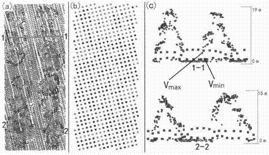
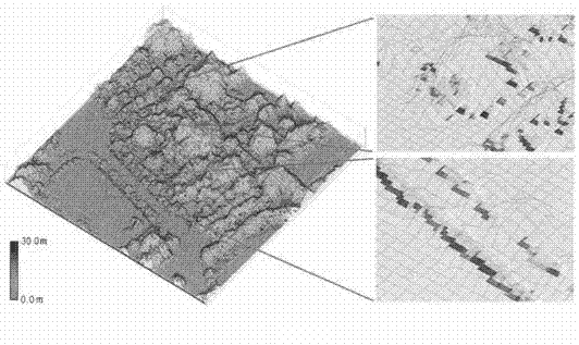
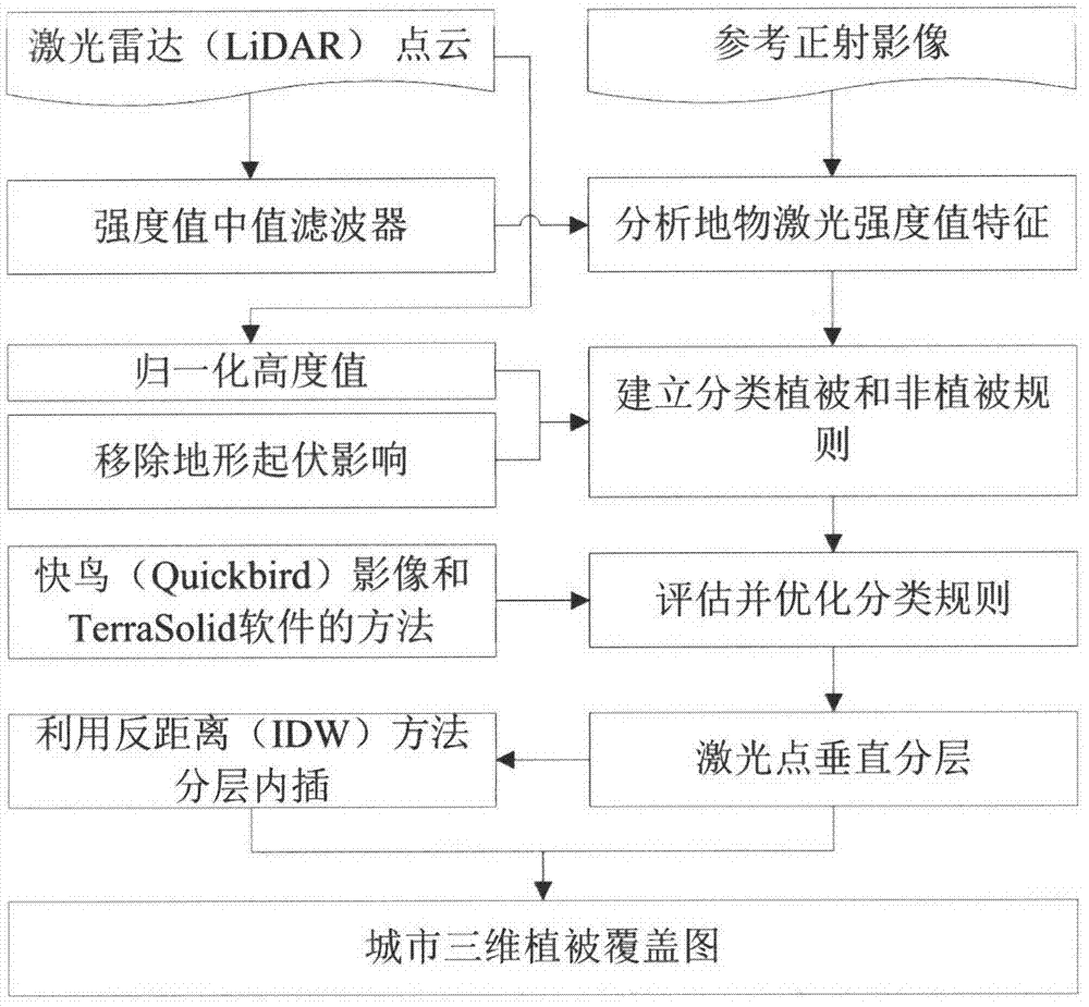
[0028] according to figure 1 The method flow shown, with "Nanjing Peace Park three-dimensional green coverage extraction" as an application example, further clarifies the present invention:

[0029] The first step is data preprocessing. A median filter based on the intensity information of airborne LiDAR point cloud data is established, and the median filter is used to filter the point cloud data to remove intensity noise. The ground elevation (DEM) value is subtracted...


PUM


Abstract

The invention discloses a method for utilizing airborne laser radar point cloud to extract urban vegetation three-dimensional coverage map. The method comprises the following steps of data pro-processing, airborne laser radar (LiDAR) point cloud data median filtering and data height normalization. A classification rule based on a strength value and space information is established according to a result analyzed after a ground feature laser point strength value is calibrated according to the aerial photograph condition and is used for distinguishing vegetation laser points and non-vegetation laser points. An existing tool is utilized to evaluate the effectiveness of the rule, and laser point classification is performed after optimization. The laser points are vertically stratified, and an inverse distance method (IDW) is utilized to conduct interpolation on stratified data to obtain a vegetation three-dimensional coverage map.

Description

technical field [0001] The invention relates to a method for extracting three-dimensional coverage of urban vegetation by using airborne lidar point clouds. The technical field of the invention is the technical field of remote sensing of resources and environments or digital image processing, and is especially suitable for extracting geographical information data of three-dimensional vegetation coverage in ecological cities. Background technique [0002] In the extraction of urban vegetation coverage information, the application of high-resolution images is relatively mature, but only the coverage distribution of the vegetation plane can be obtained, and there are problems such as the smaller projected area of ​​​​mountain vegetation. With the vigorous development of airborne lidar (LiDAR) technology in recent years, it has become possible for scholars at home and abroad to conduct research on urban 3D vegetation coverage based on LiDAR point clouds and the combination of ima...

Claims


Application Information

Patent Timeline
Patent Type & Authority Applications(China)
IPC IPC(8): G01S17/89
CPCG01S17/89
Inventor 韩文泉赵书河谢顺平雷步云冯学智王安
Owner NANJING UNIV
Why Eureka
Try Eureka