Beidou space-based high-precision real-time positioning method

A real-time positioning, high-precision technology, applied in satellite radio beacon positioning systems, measuring devices, instruments, etc., to achieve the effect of improving the performance of positioning services, centralizing the ground central station, and enhancing the performance of positioning services

Inactive Publication Date: 2015-04-29
NAT TIME SERVICE CENT CHINESE ACAD OF SCI
View PDF2 Cites 22 Cited by
  • Summary
  • Abstract
  • Description
  • Claims
  • Application Information

AI Technical Summary

Problems solved by technology

At present, in the precise point positioning technology, the main means of obtaining precise data is the Internet. In China, there is no realization technology for broadcasting correction data through satellites.

Method used


Image

  • Beidou space-based high-precision real-time positioning method
  • Beidou space-based high-precision real-time positioning method
  • Beidou space-based high-precision real-time positioning method

Examples


Embodiment Construction

[0021] The present invention will be further described below in conjunction with the accompanying drawings and embodiments, and the present invention includes but not limited to the following embodiments.
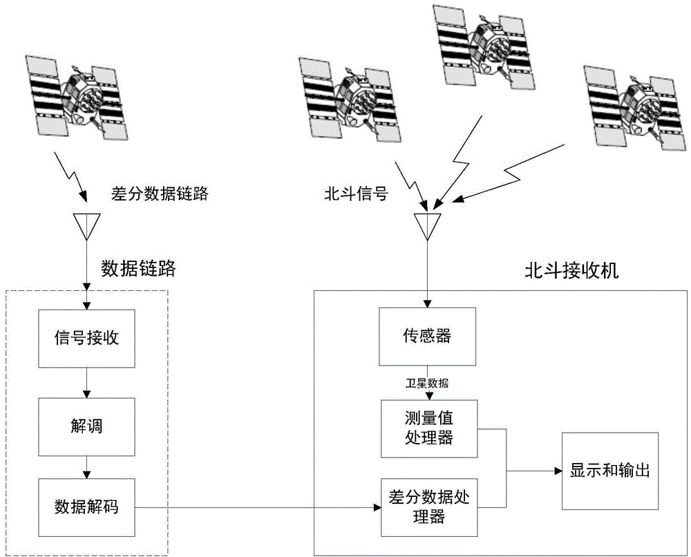
[0022] The basic idea of ​​the present invention is: the ground monitoring station receives the Beidou navigation satellite downlink navigation signal, performs pseudorange measurement and carrier phase measurement, collects the observation value data of each monitoring station, and centrally calculates the Beidou navigation satellite in the visible area at the ground master control station. Various types of differential correction data, edit differential broadcast messages, generate differential broadcast signals, forward differential correction information through geosynchronous orbit satellites, and broadcast to all users in the coverage area, realizing high-precision real-time positioning of the Beidou satellite navigation system, effectively improving user positioning a...


PUM


Abstract

The invention provides a Beidou space-based high-precision real-time positioning method. The method comprises the following steps: firstly, generating difference revised data, then generating a difference broadcast telegraph text, adopting two pseudorandom sequences to generate a short precise code, and conducting spectrum spread and carrier modulation on the difference broadcast telegraph text and the short precise code so as to generate a difference broadcast signal; a user positioning terminal combines difference broadcast data of the difference broadcast signal and Beidou navigation satellite observation data to conduct positioning calculation so as to realize high-precision real-time positioning. The method can effectively realize decimeter-degree high-precision real-time positioning in the coverage area of a geosynchronous orbit satellite, and quickly improves and enhances the positioning service performance of a Beidou satellite navigation system.

Description

technical field [0001] The invention relates to a high-precision real-time positioning realization method based on differential information broadcast by geosynchronous orbit satellites for the Beidou satellite navigation system. Background technique [0002] At present, the accuracy of each satellite navigation system in the world within its coverage area is not better than the meter level. The accuracy of the Beidou satellite navigation system area system in the coverage area is 10 meters. For ordinary users who require meter-level positioning accuracy, using a satellite navigation system service independently can basically meet the positioning needs of most users. For users with sub-meter requirements for higher precision, other auxiliary technologies are needed to meet their precision requirements. [0003] At present, the auxiliary technologies aimed at improving the service performance of satellite navigation systems at home and abroad can be divided into: satellite-ba...

Claims


Application Information

Patent Timeline
Patent Type & Authority Applications(China)
IPC IPC(8): G01S19/41
CPCG01S19/41
Inventor 杨强文卢晓春成芳孙保琪刘枫赵爱萍
Owner NAT TIME SERVICE CENT CHINESE ACAD OF SCI
Why Eureka
Try Eureka