Cooperative localization-based terminal-to-terminal orientation method and device

A technology for collaborative positioning and inter-terminals, applied to measuring devices, direction finders using radio waves, satellite radio beacon positioning systems, etc., can solve problems such as limiting the scope of application, and achieve the effect of improving the scope of application and high commercial value

Inactive Publication Date: 2015-07-29
PEKING UNIV
View PDF0 Cites 19 Cited by
  • Summary
  • Abstract
  • Description
  • Claims
  • Application Information

AI Technical Summary

Problems solved by technology

However, this method requires four commo...

Method used


Image

  • Cooperative localization-based terminal-to-terminal orientation method and device
  • Cooperative localization-based terminal-to-terminal orientation method and device
  • Cooperative localization-based terminal-to-terminal orientation method and device

Examples


Embodiment Construction

[0025] The features and technical effects of the technical solution of the present invention will be described in detail below with reference to the accompanying drawings and in conjunction with exemplary embodiments, but the present invention is not limited to this embodiment.

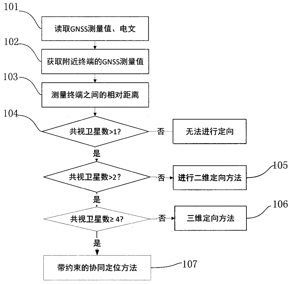
[0026] figure 1 It is a schematic flow diagram of the method for realizing the orientation between vehicle terminals in combination with wireless ranging and pseudo-range double difference in the present invention, such as figure 1 As shown, the method includes the following steps:

[0027] Step 101, read GNSS measurement value and navigation message. Specifically:

[0028] GNSS refers to Global Navigation Satellite Systems (Global Navigation Staellite Systems), including but not limited to GPS, Galileo, GLONASS and Beidou systems. The system starts, the satellite processing module receives the satellite signal, and after the tracking channel is ready for the measured value, an interrupt is sent to...


PUM


Abstract

The invention discloses a cooperative localization-based terminal-to-terminal orientation method. The cooperative localization-based terminal-to-terminal orientation method is characterized in that wireless ranging and pseudo range double difference orientation methods are used in combination. The cooperative localization-based terminal-to-terminal orientation method comprises the following steps that: a terminal acquires satellite observation data of a global navigation system so as to obtain satellite pseudo range information; a pseudo range difference model is established through utilizing satellite observation values of the global navigation system and navigation satellite observation values of adjacent terminals; terminal-to-terminal distances which are measured through the pseudo range double difference and wireless ranging methods are combined together, so that a terminal-to-terminal orientation equation is established; and orientation results can be obtained through adopting different orientation methods under the situation that common visible satellites are different in quantity, and terminal-to-terminal orientation can be realized when common visible satellites are fewer than four. The invention also discloses a terminal-to-terminal orientation device. With the cooperative localization-based terminal-to-terminal orientation method and the device adopted, terminal-to-terminal orientation when common visible satellites are fewer than four can be realized, and therefore, the cooperative localization-based terminal-to-terminal orientation method and device of the invention have high practical values.

Description

technical field [0001] The present invention relates to the fields of global satellite navigation system, wireless network and Internet of Vehicles, and more specifically, relates to an orientation method and device between vehicle terminals based on the global satellite navigation system, wireless ranging and Internet of Vehicles. Background technique [0002] The current Internet of Vehicles technology is one of the two major development trends of automotive technology. The Internet of Vehicles system refers to the use of advanced sensor technology, network technology, computing technology, control technology, and intelligent technology to comprehensively perceive roads and traffic, realize large-scale, large-capacity data interaction between multiple systems, and monitor each vehicle. Full-time traffic control, full-time and space-time traffic control for each road, providing networks and applications that focus on traffic efficiency and traffic safety. Among them, the f...

Claims


Application Information

Patent Timeline
IPC IPC(8): G01S19/41G01S19/46
CPCG01S19/46G01S3/14G01S11/02
Inventor 雷登云陈昌雁张彦彬路卫军崔小欣黄永灿于敦山
Owner PEKING UNIV
Why Eureka
Try Eureka