City road network vehicle coordinate correcting method and device based on plough satellite

A technology for urban road network and coordinate correction, which is applied to the traffic control system of road vehicles, measuring devices, satellite radio beacon positioning systems, etc.

Active Publication Date: 2015-04-29
HEFEI GELYU INFORMATION TECH
View PDF5 Cites 19 Cited by
  • Summary
  • Abstract
  • Description
  • Claims
  • Application Information

AI Technical Summary

Problems solved by technology

[0003] The urban road network environment is different from rural and suburban roads. Due to the influence of a large number of hig

Method used


Image

  • City road network vehicle coordinate correcting method and device based on plough satellite
  • City road network vehicle coordinate correcting method and device based on plough satellite
  • City road network vehicle coordinate correcting method and device based on plough satellite

Examples


Embodiment Construction

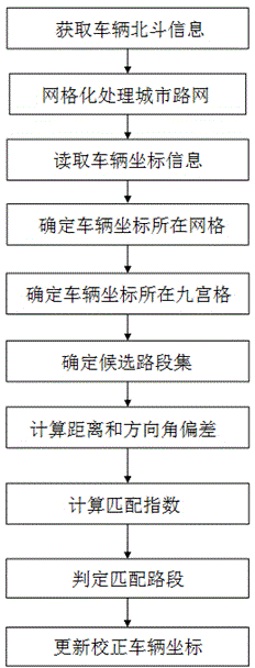
[0036] Below, the present invention will be further described in conjunction with the accompanying drawings and specific embodiments.

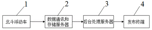
[0037] Such as figure 1 As shown, a Beidou-based urban road network vehicle coordinate correction method is implemented by using several Beidou floating vehicles 1, data communication and storage servers 2, background processing servers 3, and publishing terminals 4 connected in sequence (such as image 3 shown), the method includes the following steps:

[0038] S1. Use the floating car technology to detect the dynamic parameters of all Beidou floating cars 1 in the urban road network, including time, coordinates and direction angle data. The detected dynamic parameters are stored in the background processing server 3 in real time through the data communication and storage server 2.

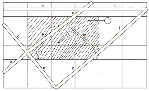
[0039] S2. On the basis of the urban road network, cover the grid processing layer to determine the number and boundary range of each grid. The basic unit of th...


PUM


Abstract

The invention provides a city road network vehicle coordinate correcting method based on the plough satellite. The city road network vehicle coordinate correcting method comprises the steps of obtaining vehicle plough satellite information; processing a city road network in a meshing mode; reading vehicle coordinate information; determining a mesh where vehicle coordinates are located; determining the sudoku where the vehicle coordinates are located; determining a candidate road segment set; calculating distance and direction angle deviation; calculating matching indexes; determining matching road segments; updating the corrected vehicle coordinates. The invention further discloses a city road network vehicle coordinate correcting device based on the plough satellite. According to the city road network vehicle coordinate correcting method and device based on the plough satellite, by structuring the sudoku and a coordinate matching index model, vehicle coordinates in the city road network can be quickly and accurately positioned, the deviation of city network plough satellite positioning under the high-rise building traffic environment is reduced, the speed of matching massive data is increased, and the operation efficiency and the service level of a floating vehicle traffic information collecting system are increased.

Description

technical field [0001] The invention relates to the technical field of urban road network vehicle positioning based on Beidou data, in particular to a Beidou-based urban road network vehicle coordinate correction method and device. Background technique [0002] Floating vehicle traffic information collection technology is a technology that uses the vehicle's dynamic position change information to extract real-time road conditions by installing Beidou, GPS and other devices on the vehicle. Based on the floating vehicle displacement data, the time series vehicle position coordinates are matched with the map. Calculate the average speed of all floating points and the travel speed of the road section, and then extract the traffic status of the road. This technology includes key processing programs such as data preprocessing, map matching, path estimation, and historical speed supplementation. The processing models of each program are also diverse. Yes, there are differences in a...

Claims


Application Information

Patent Timeline
IPC IPC(8): G08G1/0969G01S19/42
CPCG01S19/42G08G1/123
Inventor 高万宝吴先会张广林邹娇
Owner HEFEI GELYU INFORMATION TECH
Why Eureka
Try Eureka