System and method for collaboratively navigating, investigating and monitoring unmanned aerial vehicle and intelligent vehicle

A technology of collaborative navigation and monitoring system, applied in three-dimensional position/channel control, two-dimensional position/channel control and other directions

Active Publication Date: 2015-06-10
NORTHEASTERN UNIV
View PDF7 Cites 71 Cited by
  • Summary
  • Abstract
  • Description
  • Claims
  • Application Information

AI Technical Summary

Problems solved by technology

However, the invention relies too much on detectors for environmental perception, and there are certain limitations in actual processing.

Method used


Image

  • System and method for collaboratively navigating, investigating and monitoring unmanned aerial vehicle and intelligent vehicle
  • System and method for collaboratively navigating, investigating and monitoring unmanned aerial vehicle and intelligent vehicle
  • System and method for collaboratively navigating, investigating and monitoring unmanned aerial vehicle and intelligent vehicle

Examples


Embodiment Construction

[0046] The specific embodiments of the present invention will be described in detail below in conjunction with the drawings.

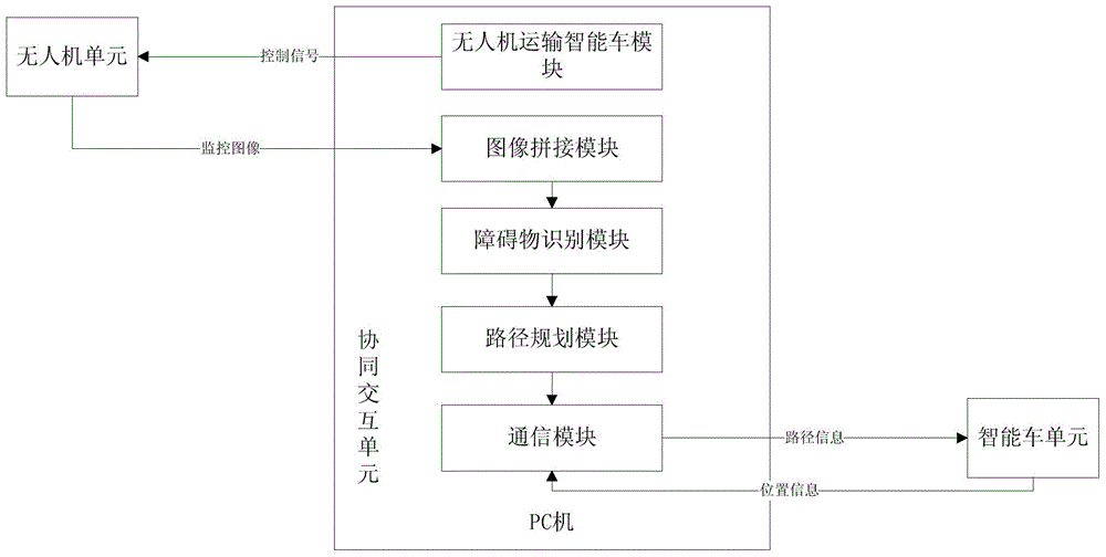
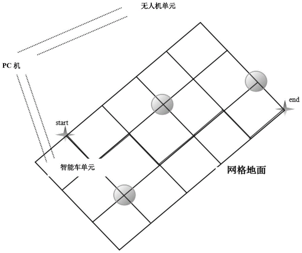
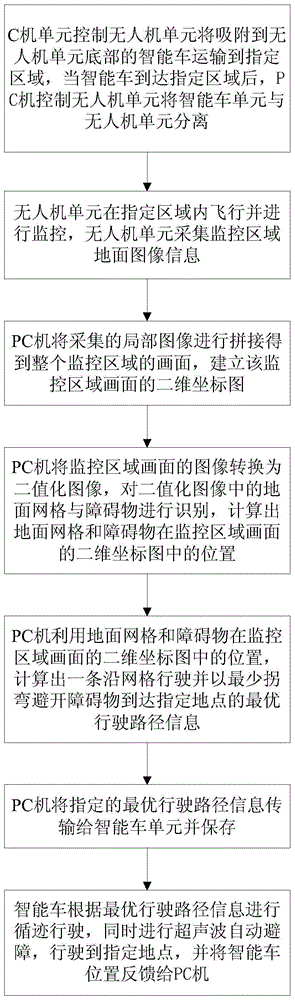
[0047] A coordinated navigation and reconnaissance monitoring system for drones and smart cars, such as figure 1 Shown, including UAV unit, PC and smart car unit.

[0048] The UAV unit is used to monitor the designated area, collect the ground image of the monitoring area at a fixed frequency, and transmit it to the collaborative interaction unit via WIFI, and at the same time transport the smart car unit attached to the bottom of the UAV unit to the designated area.

[0049] The PC is used to splice multiple ground images of the monitoring area collected by the drone unit to get the picture of the entire monitoring area, identify obstacles in the image, and plan the driving path of the smart car unit to obtain optimal driving path information At the same time, it communicates with the smart car unit and transmits the specified optimal driving path informatio...


PUM


Abstract

The invention discloses a system and a method for collaboratively navigating, investigating and monitoring an unmanned aerial vehicle and an intelligent vehicle. The system comprises an unmanned aerial vehicle unit, a PC (personal computer) and an intelligent vehicle unit, wherein the PC controls the unmanned aerial vehicle unit to transport the intelligent vehicle unit which is adsorbed to the bottom of the unmanned aerial vehicle unit to a designated area; the unmanned aerial vehicle flies and monitors in the designated area, and acquired a ground image of the monitored area at fixed frequency; the PC splices a plurality of acquired ground images of the monitored area to obtain the picture of the whole monitored area, and converts the picture into a binary picture; a ground grid and a barrier are identified to calculate positions of the ground grid and the barrier in a two-dimensional coordinate graph of the picture of the monitored area; optimal travelling path information is calculated by utilizing the positions of the ground grid and the barrier in the two-dimensional coordinate graph of the picture of the monitored area, and transmitted to the intelligent vehicle unit for being stored; the intelligent vehicle unit performs tracking travelling according to the optimal travelling path, and performs ultrasonic automatic obstacle avoidance to travel to a designated place.

Description

Technical field [0001] The invention belongs to the cross field of unmanned aerial vehicles and intelligent vehicles, and specifically relates to a coordinated navigation and reconnaissance monitoring system and method for unmanned aerial vehicles and intelligent vehicles. Background technique [0002] The unmanned aerial vehicle has a history of more than 80 years since its inception. In recent years, with the improvement of sensor technology (such as the rapid development of MEMS devices), the advancement of microprocessor technology, the improvement of power devices, the application of new materials, and the improvement of battery life, all have become four-rotor unmanned aerial vehicles. The redevelopment of the company provides the necessary hardware conditions. Compared with conventional rotorcraft such as helicopters with traditional layouts, multi-rotor aircraft has a more compact structure, high power utilization efficiency, and the four rotor torques can cancel each ot...

Claims


Application Information

Patent Timeline
IPC IPC(8): G05D1/02G05D1/10
Inventor 任涛赵思佳程瑞吕云鹏张鑫月
Owner NORTHEASTERN UNIV
Why Eureka
Try Eureka