Space-ground bistatic differential interferometry baseline coordinate and deformation quantity measurement method

A satellite-ground dual-base, differential interference technology, applied in radio wave measurement systems, satellite radio beacon positioning systems, measurement devices, etc., can solve the problems of high cost and inconvenient wide application, and achieve high-precision deformation estimation and elimination Common mode error, the effect of improving the signal-to-noise ratio

Active Publication Date: 2015-06-24
BEIJING INSTITUTE OF TECHNOLOGYGY
View PDF7 Cites 9 Cited by
  • Summary
  • Abstract
  • Description
  • Claims
  • Application Information

AI Technical Summary

Problems solved by technology

However, the cost of DGPS equipment is relativ

Method used


Image

  • Space-ground bistatic differential interferometry baseline coordinate and deformation quantity measurement method
  • Space-ground bistatic differential interferometry baseline coordinate and deformation quantity measurement method
  • Space-ground bistatic differential interferometry baseline coordinate and deformation quantity measurement method

Examples


Embodiment 1

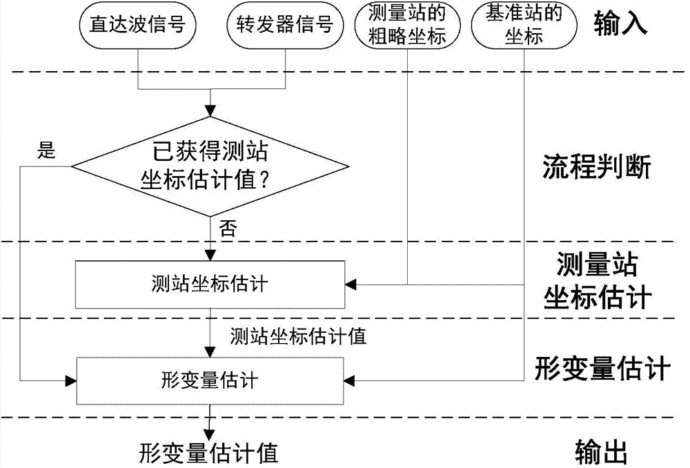
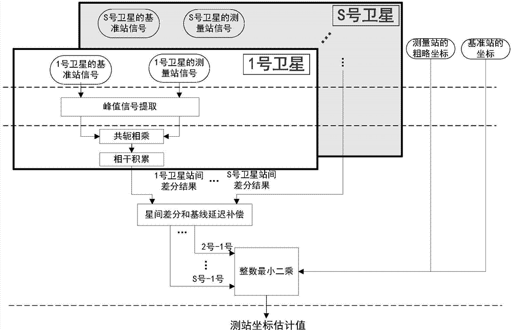
[0035] Embodiment 1, as figure 1 As shown, S satellites are used to transmit signals to the reference station and the measuring station, and the coordinates of the measuring station are measured. The reference station is set as a radar to receive the direct wave signal from each navigation satellite; the measuring station is set as a transponder. The transponder receives the signal of each navigation satellite, and the signal is forwarded to the reference station as the signal of the measuring station; the space coordinate system is established with the reference station as the origin, such as figure 2 Shown is the flow of this method. This method includes two parts, which are the coordinate estimation process of the measuring station and the estimation process of the deformation variable. Steps 1 to 7 are the coordinate estimation process of the measuring station. image 3 , the specific steps of the method are as follows:

[0036] Step 1: Perform frequency mixing processin...

Embodiment 2

[0130] Embodiment 2, as figure 1 As shown, S satellites are used to transmit signals to the reference station and the measurement station to measure the deformation of the measurement station. The reference station is set as a radar to receive the direct wave signal from each navigation satellite; the measurement station is set as a transponder, and the transponder The signal of each navigation satellite is received, and the signal is forwarded to the reference station as the signal of the measuring station; the space coordinate system is established with the reference station as the origin, such as figure 2 Shown is the process flow of this method, which includes two parts, which are respectively the coordinate estimation process of the measuring station and the estimation process of the deformation amount. The measurement process of the deformation amount in this embodiment is as follows Figure 4 , wherein steps 1 to 4 are correspondingly equal to steps 1 to 4 in embodimen...


PUM


Abstract

The invention discloses a space-ground bistatic differential interferometry baseline coordinate and deformation quantity measurement method. S satellites are adopted to emit signals to a base station and a measurement station, the measurement station is arranged at the position needing coordinate measurement or deformation quantity measurement, frequency mixing processing is carried out on phase positions of direct-wave signals and phase positions of intrinsic signals as well as phase positions of signals of the measurement station and the phase positions of the intrinsic signals in the base station, and the direct-wave signal phase position history and the measurement station signal phase position history are obtained; the spatial difference phase of a direct-wave azimuth signal and a measurement station azimuth signal is worked out; when coordinate measurement is carried out, a reference satellite is selected, intersatellite difference is carried out on the spatial difference phase between a navigation satellite and the reference satellite, an intersatellite difference equation set is obtained and compensated, and an estimated value of a baseline coordinate is obtained after resolution. When deformation quantity measurement is carried out, difference is carried out on the spatial difference phases of the adjacent time periods, a time differential equation set is obtained and compensated, and a deformation quantity coordinate is obtained after resolution. The method is high in precision, low in cost and successive in time.

Description

technical field [0001] The invention belongs to the technical field of radar signal processing. Background technique [0002] Differential GPS (DGPS) uses navigation satellites as the launching platform, and arranges the differential GPS of the measuring station at the position where the coordinates need to be measured, and arranges the differential GPS of the reference station at another position. The common-mode characteristic of errors such as ephemeris and ephemeris, using high-precision carrier phase, eliminates common-mode errors through differential processing, so as to realize high-precision estimation of the coordinates of the measured value, and then perform time difference to calculate the deformation of the measuring station relative to the reference station Carry out real-time monitoring. [0003] Although one reference station can be used with multiple survey stations, a DGPS device needs to be arranged at each survey station when measuring coordinates. Howev...

Claims


Application Information

Patent Timeline
IPC IPC(8): G01S19/41
CPCG01S19/41
Inventor 曾涛田卫明张天胡程
Owner BEIJING INSTITUTE OF TECHNOLOGYGY
Why Eureka
Try Eureka