Method for measuring ground resolution of remote sensing satellite

A technology of ground resolution and measurement method, which is applied in the field of satellite ground resolution measurement, and can solve problems such as low precision and unstable measurement results

Active Publication Date: 2015-07-08
CHINA CENT FOR RESOURCES SATELLITE DATA & APPL
View PDF3 Cites 3 Cited by
  • Summary
  • Abstract
  • Description
  • Claims
  • Application Information

AI Technical Summary

Problems solved by technology

In the traditional ground resolution measurement method, for example, the determination of the center position of the target and the determination of the exact resolution position are all visually interpreted by the human eye. The measurement results are often different from person to person, and the measurement results are not stable enough and the accuracy is not high.

Method used


Image

  • Method for measuring ground resolution of remote sensing satellite
  • Method for measuring ground resolution of remote sensing satellite
  • Method for measuring ground resolution of remote sensing satellite

Examples


Embodiment Construction

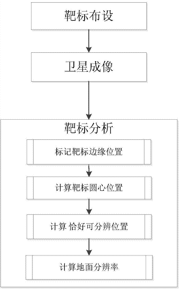
[0035] The present invention proposes a method for measuring the ground resolution of remote sensing satellites, such as figure 1 The specific implementation steps shown are as follows:

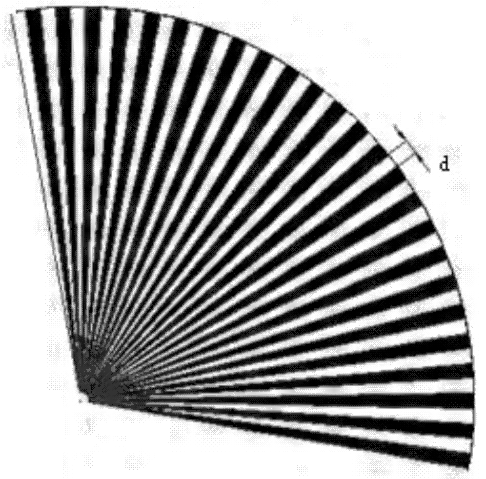
[0036] The first step: For resolution measurement, it is necessary to lay fan-shaped radial targets and rectangular targets; lay fan-shaped radial targets and rectangular targets on the ground black substrate, record the longitude and latitude information of fan-shaped radial targets and rectangular targets, and the information of fan-shaped radial targets. The arc length of the outer edge of the high reflectivity white target and the low reflectivity black target. Among them, the opening angle of the fan-shaped target is greater than 90 degrees, generally this angle is 110 degrees, the angle between one side edge and the flight direction of the satellite is greater than 5 degrees, and the range of chord-to-diameter ratio is 1:15-1:35, generally 1:26 , including high-reflectivity white targe...


PUM


Abstract

The invention discloses a method for measuring the ground resolution of a remote sensing satellite. The method comprises the following steps: laying a fan-shaped radial target, a rectangular target and a black substrate; imaging the area of the fan-shaped radial target and the rectangular target in cloudless weather by using a to-be-measured satellite, thereby obtaining a target image; and finally, analyzing the target image, determining the target edge position according to the actual imaging result of the target, calculating the coordinate of the center of circle of the fan-shaped radial target, determining the just resolvable position coordinate, and calculating to obtain the ground resolution. Compared with the prior art, the method disclosed by the invention has the advantages that the coordinates of the center of circle of a target image and the just resolvable position coordinate are calibrated, errors brought by visual contact of human eyes are avoided, accurate measurement of the ground resolution of a high-resolution satellite is realized, and compared with a conventional method, the method disclosed by the invention has the advantages of high precision and stable measurement result.

Description

technical field [0001] The invention relates to a satellite ground resolution measurement method, in particular to a high-resolution remote sensing satellite ground resolution measurement method. Background technique [0002] Ground resolution is a measure of the ability of a remote sensing image to distinguish the minimum distance between two adjacent features, and it is an important indicator reflecting the quality of a remote sensing image. Beyond the limit of resolution, two adjacent objects appear as a single target on the image. The actual distance of the resolution value on the ground is called the ground resolution. [0003] The measurement of the ground resolution generally uses a camera to image a black and white target, analyzes and calculates the target image, and finally obtains the ground resolution of the camera. In the traditional ground resolution measurement method, for example, the determination of the position of the center of the target circle and the ...

Claims


Application Information

Patent Timeline
Patent Type & Authority Applications(China)
IPC IPC(8): G01C25/00H04N17/02
CPCG01C25/00
Inventor 林军李运伟喻文勇宋超宇邵俊
Owner CHINA CENT FOR RESOURCES SATELLITE DATA & APPL
Why Eureka
Try Eureka