Beidou foundation navigation network ground monitoring station pseudolite and control method

A ground monitoring station and pseudolite technology, which is applied to satellite radio beacon positioning systems, measurement devices, radio wave measurement systems, etc. Inter-link time synchronization, realizing the effect of inter-satellite link time synchronization

Active Publication Date: 2015-07-08
CHENGDU CORPRO TECH CO LTD
View PDF6 Cites 22 Cited by
  • Summary
  • Abstract
  • Description
  • Claims
  • Application Information

AI Technical Summary

Problems solved by technology

The timing accuracy of the traditional pseudolite system is poor, and it cannot meet the req

Method used


Image

  • Beidou foundation navigation network ground monitoring station pseudolite and control method
  • Beidou foundation navigation network ground monitoring station pseudolite and control method
  • Beidou foundation navigation network ground monitoring station pseudolite and control method

Examples


Embodiment Construction

[0031] The technical solution of the present invention will be further described in detail below in conjunction with the accompanying drawings, but the protection scope of the present invention is not limited to the following description.

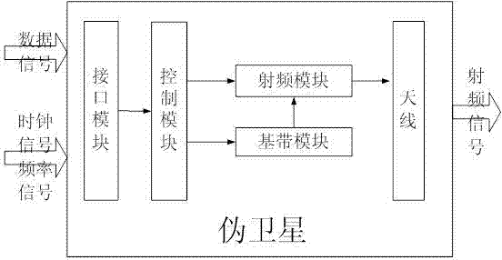
[0032] Such as figure 1 As shown, the pseudolite of the Beidou ground-based navigation network ground monitoring station is used to realize the physical simulation of the output signal of a single satellite, including the interface module, control module, baseband module, radio frequency module and antenna. The input terminals of the interface module are connected with the data signal in time. The clock signal is connected, the output end of the interface module is connected with the control module, one output end of the control module is directly connected with the antenna through the radio frequency module, the other output end of the control module is connected with the radio frequency module through the baseband module, and the radio fre...


PUM


Abstract

The invention discloses a Beidou foundation navigation network ground monitoring station pseudolite and a control method. The Beidou foundation navigation network ground monitoring station pseudolite is used for achieving physical simulation of output signals of a single satellite and comprises an interface module, a control module, a base band module, a radio frequency module and an antenna. The input end of the interface module is connected with a data signal and a clock signal. The output end of the interface module is connected with the control module. One output end of the control module is directly connected with the antenna through the radio frequency module, and the other output end of the control module is connected with the radio frequency module through the base band module. The radio frequency module is connected with the antenna. The Beidou foundation navigation network ground monitoring station pseudolite can simulate pseudolite signals of a Beidou system and achieve physical simulation of the output signals of the single satellite. Pseudolite navigation signal pseudo-random codes are selected from the unused Beidou satellite signal pseudo code space and are not relevant to existing satellite signals. High-precision inter-satellite link time synchronization is achieved through a network time protocol.

Description

technical field [0001] The invention relates to a pseudo-satellite of a Beidou ground-based navigation network ground monitoring station and a control method. Background technique [0002] China's BeiDou Navigation Satellite System (BDS) is a global satellite navigation system developed by China itself. It is the third mature satellite navigation system after the US Global Positioning System (GPS) and Russia's GLONASS satellite navigation system. Beidou Satellite Navigation System (BDS), GPS of the United States, GLONASS of Russia, and GALILEO of the European Union are certified suppliers by the United Nations Satellite Navigation Commission. The Beidou satellite navigation system consists of three parts: the space segment, the ground segment and the user segment. It can provide high-precision, high-reliability positioning, navigation, and timing services for all types of users around the world, all-weather, and has short-message communication. It has initially possessed r...

Claims


Application Information

Patent Timeline
IPC IPC(8): G01S19/11
CPCG01S19/11
Inventor 柏杰明元赵文多徐娜
Owner CHENGDU CORPRO TECH CO LTD
Why Eureka
Try Eureka