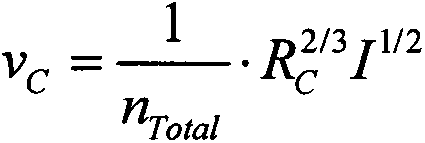
Calculation method for debris flow section mean flow rate and application
A technology of average flow velocity and debris flow, which is applied in fluid velocity measurement, special data processing application, velocity/acceleration/shock measurement, etc., and can solve problems such as not considering the influence of viscosity coefficient flow velocity
- Summary
- Abstract
- Description
- Claims
- Application Information
AI Technical Summary
Problems solved by technology
Method used
Image
Examples
Embodiment 1
[0040] A debris flow ditch is located on the left bank of the Mianyuan River, with a drainage area of about 1.36km 2, the terrain of the upper reaches of the main ditch is steep, the highest point is located on the east side of the basin, with an altitude of 1987m; the lowest point is located near the Mianyuan River at the mouth of the ditch, with an altitude of 810m, and a relative height difference of 1177m; The gradient is 412‰. The plane shape of the basin is peach-leaf-shaped, which is conducive to the confluence of mud-rock fluids. After the earthquake, many debris flows occurred, and the trench was severely cut down, with a cutting depth of about 30m. The trench was in a "V" shape with an average width of about 3-5m. The steep topographical conditions provide good conditions for the accumulation of rainstorms and floods, while the better air conditions provide favorable conditions for the development of unfavorable geological phenomena in the gully area and the accum...
Embodiment 2
[0048] A debris flow ditch is located in the north of Qingpingchang Town, a mountainous area in the northwest of Mianzhu City, Sichuan Province. It belongs to a ditch on the left bank of the Mianyuan River in the upper reaches of the Tuojiang River System in the Yangtze River Basin. The coordinates of the ditch mouth are N31.5°, E104.1°. In terms of landform, it belongs to tectonic erosion cutting steep low-middle mountain landform, slope and gully landform. The basin generally extends east-west, with a catchment area of 7.81km 2 , the total length of the main ditch is 3.25km, the lowest point in the basin is located at the mouth of the ditch at an altitude of 883m, and the highest peak is located at the Dingziya of Jiuding Mountain in the eastern part of the watershed, with an altitude of 2402m and a relative height difference of 1519m. There have been many large-scale debris flows in the ditch, which pose a great threat to Qingping Township.
[0049] Utilize the measureme...
PUM
 Abstract
Description
Claims
Application Information
 - R&D
- Intellectual Property
- Life Sciences
- Materials
- Tech Scout
- Unparalleled Data Quality
- Higher Quality Content
- 60% Fewer Hallucinations
Browse by: Latest US Patents, China's latest patents, Technical Efficacy Thesaurus, Application Domain, Technology Topic, Popular Technical Reports.
© 2025 PatSnap. All rights reserved.Legal|Privacy policy|Modern Slavery Act Transparency Statement|Sitemap|About US| Contact US: help@patsnap.com


