Method for automatic return flight without GPS (global positioning system) signal

An automatic return and signal technology, applied in the field of GPS navigation, can solve problems such as inability to locate and return

Active Publication Date: 2015-07-29
SHENZHEN PROTRULY ELECTRONICS CO LTD
View PDF6 Cites 13 Cited by
  • Summary
  • Abstract
  • Description
  • Claims
  • Application Information

AI Technical Summary

Problems solved by technology

Therefore, the traditional return method either relies on satellite positioning signals such as GPS, or relies on external control systems such as control stations. In the case of war and other situations, when the GPS has no signal and the control station is abnormal, it will not be possible to locate and return.

Method used


Image

  • Method for automatic return flight without GPS (global positioning system) signal
  • Method for automatic return flight without GPS (global positioning system) signal
  • Method for automatic return flight without GPS (global positioning system) signal

Examples


Embodiment Construction

[0018] The technical solution of this patent will be further described in detail below in conjunction with specific embodiments.

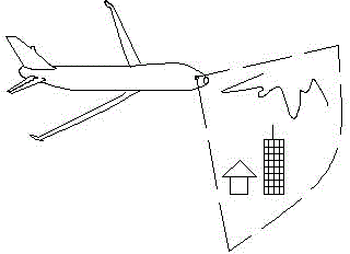
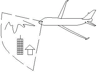
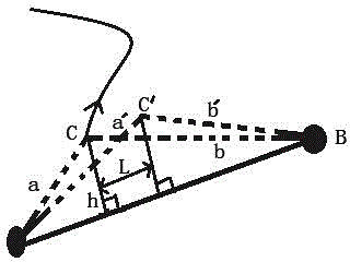
[0019] see Figure 1-5 , a method for automatically returning to the voyage when there is no GPS signal, the specific steps are as follows:

[0020] (1) During the flight, the aircraft obtains the video information of the ground buildings in real time through the high-definition camera device and stores them in the image storage system. The image recognition system extracts the characteristic information of buildings and terrain through image processing algorithms, and establishes it as a route information database;

[0021] (2) When the aircraft returns to the flight, the video information of the ground buildings is obtained in real time through the high-definition camera device, and the image recognition system extracts the characteristic information of the buildings and terrain through the image processing algorithm. The feature information of ...


PUM


Abstract

The invention discloses a method for automatic return flight without a GPS (global positioning system) signal. A high-definition camera system is adopted for acquiring ground building video information and storing the ground building video information in an image storage system in a flight process of an airplane; feature information of buildings and terrains is extracted through an image processing algorithm to build an airline information library; ground building images and terrains are also acquired during return flight; the images are processed in a vertical flip manner and compared with the existing airline feature information library; if a plurality of feature buildings or terrains are matched with the airline information library, an airline can be confirmed by a distance measuring device to confirm an instantaneous position of the airplane so as to guide the airplane to realize automatic return flight. The method also can realize automatic return flight without the GPS signal, can be widely applied to actual return flight of various airplanes such as civil airplanes, military airplanes and the like, neither depends on an external control system nor receives data such as the GPS signal and the like, and particularly has the concealed advantages when being applied to the military airplanes.

Description

technical field [0001] The invention relates to the technical field of GPS navigation, in particular to a method for automatically returning to a voyage when there is no GPS signal. Background technique [0002] The aircraft navigation system can determine the position of the aircraft and guide the aircraft to fly according to the predetermined route. There are usually three methods for determining the position of an aircraft: visual positioning, dead reckoning, and geometric positioning. The existing automatic return-to-home method when there is no GPS signal emphasizes identifying ground buildings with images, recording route information, and determining the aircraft’s location through image comparison. Instantaneous position, so as to guide the aircraft to return home automatically. Therefore, the traditional return method either relies on satellite positioning signals such as GPS, or relies on external control systems such as control stations. In situations such as war,...

Claims


Application Information

Patent Timeline
Patent Type & Authority Applications(China)
IPC IPC(8): G01C21/00
CPCG01C21/00
Inventor 龙刚林宋伟
Owner SHENZHEN PROTRULY ELECTRONICS CO LTD
Why Eureka
Try Eureka