Method for obtaining satellite solar angle and time on basis of satellite orbit characteristics

A technology of satellite orbit and sun angle, applied in the direction of measuring angles, measuring devices, instruments, etc., can solve the problems of calculation result errors, satellites are not considered, and cannot be solved, etc., and achieve the effect of accurate calculation results and convenient access methods

Active Publication Date: 2015-08-12
CHINA CENT FOR RESOURCES SATELLITE DATA & APPL
View PDF4 Cites 16 Cited by
  • Summary
  • Abstract
  • Description
  • Claims
  • Application Information

AI Technical Summary

Problems solved by technology

One method is to solve the problem based on the precise imaging date, time point and latitude and longitude information of the satellite remote sensing image, but this method will not be able to solve the problem when the imaging time of the remote sensing image is unknown; the other method is based on the nominal operation of the satellite. trajectory, but the method does not take into account the deviation of the satellite launch and the influence of various perturbation factors during the operation process, and there are certain errors in the calculation results

Method used


Image

  • Method for obtaining satellite solar angle and time on basis of satellite orbit characteristics
  • Method for obtaining satellite solar angle and time on basis of satellite orbit characteristics
  • Method for obtaining satellite solar angle and time on basis of satellite orbit characteristics

Examples


Embodiment Construction

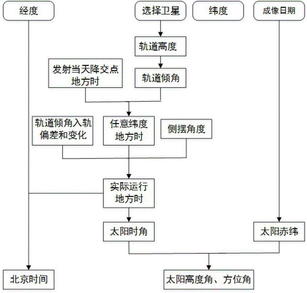
[0030] Such as figure 1 Shown, be the flow chart diagram of the inventive method, main steps are as follows:

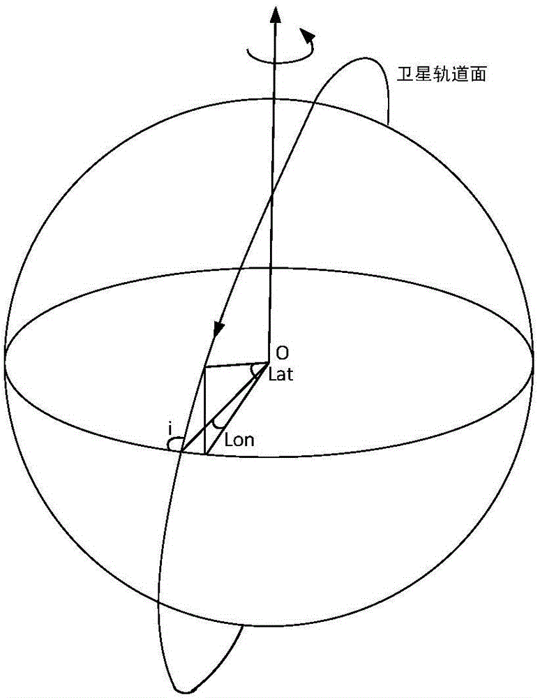
[0031] (1) Determination of satellite orbit inclination.

[0032] Remote sensing satellites are generally designed as sun-synchronous return orbits to achieve consistent lighting conditions when the satellites pass through the same location. By the Earth's non-spherical gravitational field (J 2 item), the rotation rate of the satellite's orbital plane around the polar axis is the same as the speed of the earth's revolution around the sun, which is 360 / 365=0.9856 degrees per day, thus realizing the sun-synchronous characteristic. According to this characteristic, the inclination angle of the satellite orbit is calculated from the altitude of the satellite orbit. The rate of rotation of the satellite's orbital plane The expression is:

[0033]

[0034] Since the eccentricity e of the sun-synchronous orbit is small (about 0.001) and can be ignored, then there is...


PUM


Abstract

A method for obtaining satellite solar angle and time on the basis of satellite orbit characteristics comprises the following steps: (1) according to the satellite sun-synchronous orbit characteristics, calculating the orbit inclination angle from the height of the satellite orbit; (2) according to the number of satellite orbits, calculating the longitude and Beijing time of sub-satellite point of the position where a satellite descending orbit intersects the equator, and converting the Beijing time into the local time so as to obtain the time of the position; (3) calculating to obtain the local times of any latitude where the satellite sub-satellite point pass; (4) according to the orbit injection error of satellite orbit inclination angle and the daily change rate of satellite orbit inclination angle during the operation process, calculating to obtain the change of satellite local time and actual local times of any latitude; (5) calculating to obtain the actual local time after satellite side-sway; (6) calculating to obtain the solar altitude, solar azimuth, and the Beijing time of an observation site. The provided method can precisely obtain the solar altitude, solar azimuth, and imaging time of a satellite according to a remote sensing satellite nominal orbit and changes thereof without knowing the satellite ephemeris data and specific imaging time.

Description

technical field [0001] The invention belongs to the field of remote sensing image information processing, and relates to a method for calculating satellite sun altitude angle, azimuth angle and observation time by using satellite sun synchronous characteristics and its evolution. Background technique [0002] Remote sensing image data has been widely used in land and resources survey and monitoring, disaster prevention and mitigation, agriculture, forestry and water conservancy, ecological environment, urban planning and construction, major national projects and other fields. At present, the orbit of remote sensing satellites generally adopts the sun-synchronous return orbit, that is, the nominal semi-major axis of the orbit and the orbital inclination are designed to ensure the sun-synchronous return characteristics. The sun-synchronous orbit is characterized by the same time when it passes through the same latitude, which can realize dynamic monitoring of the same area on ...

Claims


Application Information

Patent Timeline
Patent Type & Authority Applications(China)
IPC IPC(8): G01C1/00
CPCG01C1/00
Inventor 王静巧易维曾湧彭勇钊
Owner CHINA CENT FOR RESOURCES SATELLITE DATA & APPL
Why Eureka
Try Eureka