Remote sensing image terrain standardization method

A remote sensing image and terrain technology, applied in the field of remote sensing, can solve the problems that cannot truly reflect the surface conditions

Active Publication Date: 2015-08-12
HANGZHOU DADI TECH CO LTD
View PDF4 Cites 14 Cited by
  • Summary
  • Abstract
  • Description
  • Claims
  • Application Information

AI Technical Summary

Problems solved by technology

However, remote sensing observations are not only affected by atmospheric optical factors such as water vapor and aerosols, but also by terrain factors such as slope, aspect, terrain shading, sky ...

Method used


Image

  • Remote sensing image terrain standardization method
  • Remote sensing image terrain standardization method
  • Remote sensing image terrain standardization method

Examples


Embodiment Construction

[0056] The present invention will be described in detail below in conjunction with the accompanying drawings and specific embodiments.

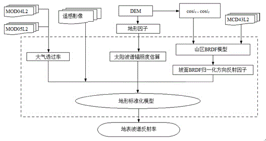
[0057] 1. Model method

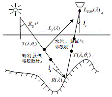
[0058] 1. The principle of remote sensing image terrain standardization

[0059] like figure 1 As shown, the radiance of the top of the atmosphere (TOA) obtained by the satellite sensor L TOP ( lambda ) consists of two parts: path radiation L p ( lambda ) and radiation reflected from the surface L ( lambda ),which is:

[0060] L TOP ( lambda )= L p ( lambda )+ L ( lambda ) T ( lambda , θ ν ) (1)

[0061] In the formula: T ( lambda , θ ν ) represents the atmospheric transmittance in the observation direction of the sensor, and is the observation zenith angle of the sensor θ ν and a function of wavelength λ. Path radiation is mainly determined by Rayleigh scattering and aerosol scattering, and the specific calculation can refer to literature (Li et al., 2002). ...


PUM


Abstract

The invention discloses a remote sensing image terrain standardization method. In a Ross Thick-Li Sparse linear kernel driver model, slope and orientation are introduced into a Ross volume scattering kernel function and a Li geometrical optical kernel function to establish a mountain BRDF (Bidirectional Reflectance Distribution Function) model; on the basis of a conventional remote sensing image terrain standardization result, an assumption of the earth surface about a Lambertian reflectance characteristic is changed, and the mountain BRDF model is introduced to maximally reduce the influence of a change in the BRDF shape of a complicated topographical region; atmospheric parameters at the border crossing moment of a satellite image are obtained by taking MODIS (Moderate Resolution Imaging Spectroradiometer) water vapor and aerosol atmosphere products as terrain standardization model parameters, so that the influence of optical factors of the atmosphere is eliminated. According to the method, radiometric distortion of a remote sensing image caused by optical properties of the atmosphere is eliminated, and in addition, radiometric distortion caused by factors such as terrain shielding and BRDF properties of the earth surface is effectively eliminated, so that the real reflectivity of the earth surface is obtained.

Description

technical field [0001] The invention belongs to the technical field of remote sensing and relates to a method for standardizing remote sensing image topography. Background technique [0002] Surface albedo is an important factor affecting surface short-wave net radiation, and high-resolution remote sensing images have become an important data source for albedo (Albedo) inversion. However, remote sensing observations are not only affected by atmospheric optical factors such as water vapor and aerosols, but also by terrain factors such as slope, aspect, terrain shading, sky visibility factors, and surface bidirectional reflectance fraction function (BRDF) or sun-surface- The influence of the geometric relationship of the sensor cannot truly reflect the surface conditions. Therefore, terrain standardization of remote sensing images has become a necessary preprocessing method for accurate inversion of surface Albedo. It is used to simultaneously eliminate or reduce atmospheric ...

Claims


Application Information

Patent Timeline
IPC IPC(8): G06F19/00
Inventor 张彦丽李新闻建光柳钦火阎广建赵军
Owner HANGZHOU DADI TECH CO LTD
Why Eureka
Try Eureka