Laying method and device of engineering control network

A technology of engineering control and elevation control points, applied in the field of surveying engineering, can solve the problems of not being widely used in surveying and mapping production units and construction enterprises, complicated technology, and many types of original data

Inactive Publication Date: 2015-08-26
SHANDONG JIAOTONG UNIV
View PDF4 Cites 10 Cited by
  • Summary
  • Abstract
  • Description
  • Claims
  • Application Information

AI Technical Summary

Problems solved by technology

[0006] Another method of GPS height measurement is to use a regional high-precision, high-resolution quasi-geoid numerical model. The quasi-geoid model can give the quasi-geoid height of any point, which can be regarded as a reference for determining the normal height. The framework converts the GPS geodetic height into a normal height, but the geoid refinement technology uses many types of raw data and complex technology, which cannot be widely used by most surveying and mapping production units and construction enterprises

Method used


Image

  • Laying method and device of engineering control network
  • Laying method and device of engineering control network
  • Laying method and device of engineering control network

Examples


Embodiment Construction

[0061] In order to make the technical problems, technical solutions and advantages to be solved by the present invention clearer, the following will describe in detail with reference to the drawings and specific embodiments.

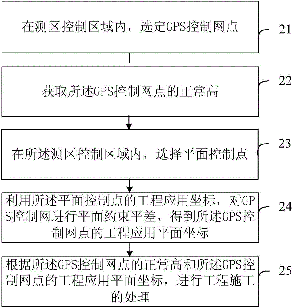
[0062] Such as image 3 As shown, it is a layout method of engineering control network, including:

[0063] Step 21, in the survey area control area, select the GPS control network point;

[0064] Step 22, obtaining the normal height h of the GPS control network point;

[0065] Step 23, select a plane control point within the survey area control area;

[0066] Step 24, using the engineering application coordinates of the plane control points to perform plane constraint adjustment on the GPS control network to obtain the engineering application plane coordinates of the GPS control network points;

[0067] Step 25, according to the normal height h of the GPS control network point and the engineering application plane coordinates of the GPS control netwo...


PUM


Abstract

The invention provides a laying method and a device of an engineering control network. The laying method of the engineering control network comprises the steps that a GPS (global positioning system) control network point is selected in a measurement control area; normal height h of the GPS control network point is acquired according to geodetic height H' of the GPS control network point relative to a reference ellipsoid and height anomaly zeta 2008 of the GPS control network point; a horizontal control point is selected in the measurement control area; horizontal constraint adjustment is performed on a GPS control network by utilizing an engineering application coordinate of the horizontal control point; an engineering application horizontal coordinate of the GPS control network point is obtained; and engineering construction treatment is performed according to the normal height h and the engineering application horizontal coordinate of the GPS control network point. According to the method and the device, the horizontal coordinate and sea level elevation can be obtained in the same GPS control network.

Description

technical field [0001] The invention relates to the technical field of surveying engineering, in particular to a method and device for laying out an engineering control network. Background technique [0002] GPS relative positioning technology can be in 10 -6 ~10 -8 The three-dimensional relative coordinates of the measured point can be obtained with an order of magnitude accuracy. In actual engineering survey applications, GPS survey has played a huge role in plane control, but the elevation information in GPS survey has not been fully utilized, and the elevation control in engineering survey still uses the traditional leveling method. This is because the elevation information obtained by GPS technology is the geodetic height relative to the WGS-84 ellipsoid, while the legal elevation system in my country is a normal height system based on the quasi-geoid. [0003] my country adopts the normal height system with quasi-geoid as the starting plane. The elevation datum is t...

Claims


Application Information

Patent Timeline
Patent Type & Authority Applications(China)
IPC IPC(8): G01C15/00G01C5/00
CPCG01C5/00G01C15/00
Inventor 宋雷王德保李晋周保兴夏小裕余正昊
Owner SHANDONG JIAOTONG UNIV
Why Eureka
Try Eureka