Automatic spatial modeling system and method of gis and es in metallogenic prediction

A modeling method and predictive model technology, applied in special data processing applications, instruments, electrical digital data processing, etc., can solve the problems of not realizing intelligence, etc., and achieve the effect of wide application fields and obvious benefits

Inactive Publication Date: 2018-04-24
JILIN UNIV
View PDF2 Cites 0 Cited by
  • Summary
  • Abstract
  • Description
  • Claims
  • Application Information

AI Technical Summary

Problems solved by technology

[0014] The present invention provides a GIS and ES automatic spatial modeling system for metallogenic prediction in order to solve the problem that the existing metallogenic prediction modeling work is mainly based on manual analysis, and human-computer interaction extracts relevant information for modeling without realizing intelligence. and methods

Method used


Image

  • Automatic spatial modeling system and method of gis and es in metallogenic prediction
  • Automatic spatial modeling system and method of gis and es in metallogenic prediction
  • Automatic spatial modeling system and method of gis and es in metallogenic prediction

Examples


specific Embodiment approach 1

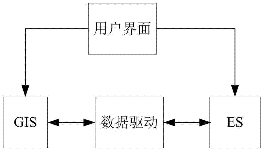
[0068] Specific implementation mode 1. Combination Figure 1 to Figure 12 This embodiment will be described. GIS and ES automatic spatial modeling system in metallogenic prediction. The overall design of the system adopts the combination of GIS and ES loosely coupled to realize the combined application of the two technologies. The two are designed as a common user interface. Through the ES reasoning machine Matching rules drive GIS spatial modeling. In this combination, GIS is used to generate a spatial database as a tool for spatial analysis and display; while ES is used to generate an application-oriented database and knowledge base, and use an inference engine to reason and drive GIS operations ( figure 1 ). figure 2 For the construction of GIS spatial information and library, the geoscience library is provided by the user, or created by the system through the geoscience library module managed by the library; image 3 It is the construction of ES database and knowledge ...

specific Embodiment approach 2

[0170] Specific embodiment two, combine Figure 2 to Figure 17 Describe this embodiment, this embodiment is the method of GIS and ES automatic spatial modeling system in the metallogenic prediction described in specific embodiment one:

[0171] The process of using ES-driven GIS to realize automatic spatial modeling of metallogenic prediction is as follows: Figure 16 , firstly establish the ES initial database automatically, then combine the ES database to automatically establish the ES knowledge rule base, and finally the ES inference engine uses the knowledge rules in the knowledge base, according to the current ES database (information in the database), combined with the files in the system’s library, to realize Complete automatic spatial modeling for metallogenic prediction. In this embodiment, the modeling of silver ore prediction is taken as an example for discussion.

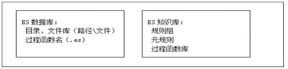
[0172] 1. Modeling system ES database

[0173] The system data described in the present embodiment...


PUM


Abstract

The invention discloses a GIS (Geographic Information System) and ES (Expert System) automatic spatial modeling system and method for use in metallogenic prediction, relates to the technical field of resource information, and aims to solve the problem that intelligence is not realized since the existing metallogenic prediction modeling work is mainly oriented to manual analysis and relevant information is extracted through man-machine interaction for modeling. A GIS is used for generating a spatial database, and is taken as a spatial analysis and display tool; an ES is used for generating a database and a knowledge base oriented to an application field, and GIS spatial modeling is driven through an ES inference engine matching rule; the spatial modeling system is designed with a uniform interface; and a prospecting space library, a prospecting model, a prediction space library and a prediction model are included. The GIS is driven by the ES to realize metallogenic prediction automatic spatial modeling: an ES initial database is automatically established; an ES knowledge rule library is automatically established in combination with the ES database; and lastly, an ES inference engine finishes metallogenic prediction automatic spatial modeling with a knowledge rule in the knowledge library according to a current ES database in combination with files in a graph library under the system.

Description

technical field [0001] The invention relates to the technical field of resource information, in particular to the fields of mathematical geology, geographic information system and expert system. Background technique [0002] The automatic integrated modeling of massive geospatial information based on vector graphics based on geoscience library has not been reported yet. The research objects are related fields: [0003] "A Rule-Based Spatial Data Integration Method" mainly realizes the conversion between spatial data in different formats, and is applied to the western surveying data of the national basic geographic information database and the national 1:50000 update data. The formulation of the data integration scheme is through the analysis of the database models of different spatial data, and according to the characteristics of each spatial data, the mapping specifications under different database models are established to formulate the integration rules, and the integrat...

Claims


Application Information

Patent Timeline
Patent Type & Authority Patents(China)
IPC IPC(8): G06F17/30
CPCG06F16/29
Inventor 叶育鑫叶水盛李德琼
Owner JILIN UNIV
Why Eureka
Try Eureka