Method for obtaining underground three-dimensional density structure

A density, three-dimensional technology, applied in the field of geophysical exploration, can solve the problems of increasing workload, affecting the accuracy of three-dimensional density structure, low accuracy, etc., to achieve the effect of improving accuracy and realizing fine characterization

Active Publication Date: 2015-08-26
INST OF MINERAL RESOURCES CHINESE ACAD OF GEOLOGICAL SCI
View PDF3 Cites 28 Cited by
  • Summary
  • Abstract
  • Description
  • Claims
  • Application Information

AI Technical Summary

Problems solved by technology

[0004] The inventor found that the accurate establishment of the initial model in the gravity 3D modeling technology can lay a good foundation for the subseq...

Method used


Image

  • Method for obtaining underground three-dimensional density structure
  • Method for obtaining underground three-dimensional density structure
  • Method for obtaining underground three-dimensional density structure

Examples


Embodiment 1

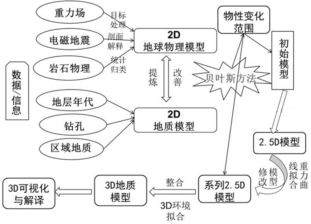
[0050] This embodiment provides a method for obtaining the underground three-dimensional density structure, such as figure 1 As shown, it specifically includes the following steps:

[0051] 1. Define the modeling area: determine the ordinate, abscissa, depth and two-dimensional 2D section spacing of the modeling area.

[0052] This step mainly determines the modeling area according to the target geological area to be studied.

[0053] 2. Preprocessing of prior information:

[0054] Such as figure 1 As shown, the prior information in this step includes geophysical information and geological information. Geophysical information includes gravity field information, electromagnetic information, seismic information and petrophysical information. Geological information includes stratum age information, drilling data information and regional geological information.

[0055] This step mainly collects the existing information of the target geological area, simplifies the geological...

Embodiment 2

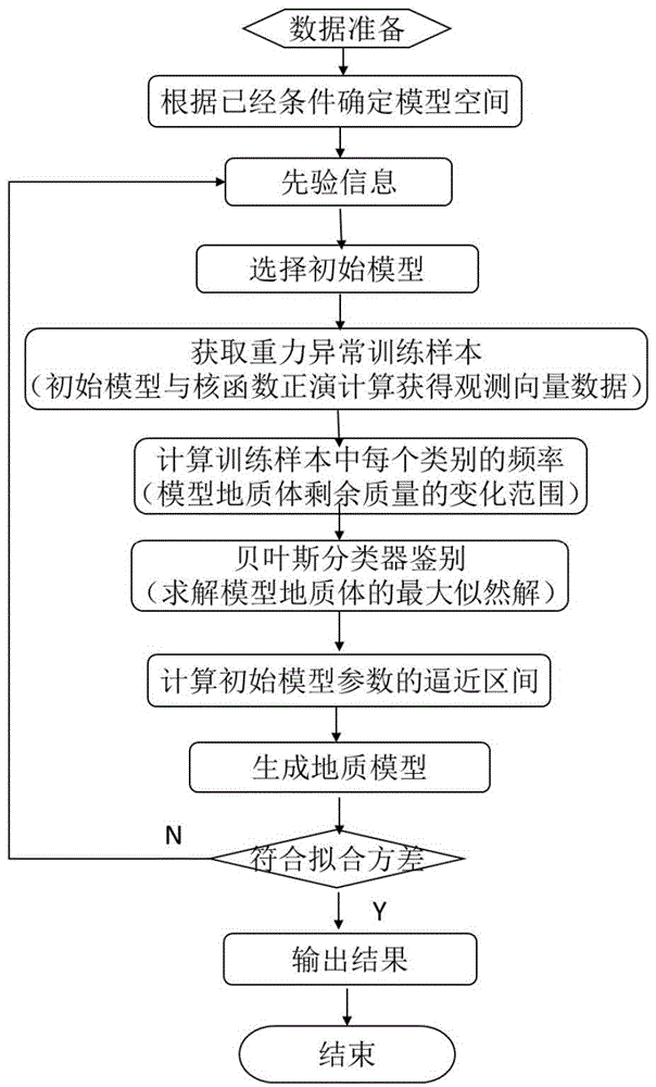
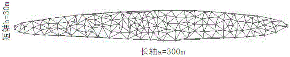
[0093] This embodiment is mainly used to verify the feasibility of establishing the initial model by the Bayesian inversion method. The specific method is as follows: select the relative density σ of the surrounding rock to be 30kg m -3 Carry out forward modeling experiments on geological bodies of any shape.

[0094] For the convenience of calculation, the triangulation method is used to divide the geological body of any shape into a number of tetrahedrons with very small units, and each tetrahedron divided into the final is approximately regarded as a unit mass sphere. The coordinates (x, y, z) of the center point and the area of ​​the triangle are used to calculate the volume of each tetrahedron, and then multiplied by the density. The calculation method of the gravity value of each tetrahedron is equivalent to the calculation of the sphere. According to Newton's law of universal gravitation, the calculation formula of the gravity value is:

[0095]

[0096] Among them...

Embodiment 3

[0099] This embodiment is an application example, specifically applying the method for obtaining the underground three-dimensional density structure provided in Embodiment 1 to actual geological exploration.

[0100] The Nihe Iron Mine was discovered for the first time in May 2007 by the Anhui Provincial Geological Survey Institute under the guidance of the porphyrite iron ore metallogenic model and the theory of large-scale ore-concentrated areas, using drilling to verify gravity and magnetic anomalies. The Nihe iron deposit is located on the northwest margin of the Luzong volcanic rock basin in Anhui Province, on the Luohe-Huangtun north-east mineralization belt. It is 3km away from the Luohe Iron Deposit in the southwest and 13km away from the Longqiao Iron Deposit in the northeast. It has the same ore-forming geological conditions as the Luohe Iron Deposit. The strata in the Nihe mining area are mainly the Cretaceous Zhuanqiao Formation (K 1 zh) and Cretaceous Shuangmiao ...


PUM

PropertyMeasurementUnit
Average widthaaaaaaaaaa
Buried depthaaaaaaaaaa
The average thicknessaaaaaaaaaa

Abstract

The invention discloses a method for obtaining an underground three-dimensional density structure, relates to the field of geophysical prospection, and solves the technical problem that the underground three-dimensional density structure cannot be accurately obtained in the prior art. The method is characterized by comprising the following steps: determining the vertical coordinates, horizontal coordinates, depth, and 2D (two-dimensional) profile interval of a modeling area; carrying out gravity inversion modeling by adopting a Naive Bayesian classification method according to prior information and the modeling area, so as to obtain an initial geological model; constructing the initial geological model into a 2D geological model by adopting a discrete body simulation method; splicing and fitting the 2D geological model into a 3D geological model; performing visualization and structure interpretation treatment on the 3D geological model, so as to obtain the underground three-dimensional density structure . The method is mainly based on the Bayesian classification inversion principle, and is combined with the discrete body simulation technology, so as to realize accurate establishment of a weight density mode, and improve the accuracy of the obtained underground three-dimensional density structure.

Description

technical field [0001] The invention relates to the field of geophysical exploration, in particular to a method for obtaining an underground three-dimensional density structure. Background technique [0002] Accurately obtaining the underground three-dimensional density structure is very important for understanding and mastering the distribution of geological bodies in the deep earth. As an important means of geophysical exploration, gravity 3D modeling technology can calculate the underground 3D density structure by measuring the gravity field information in the area, and then infer the distribution of geological bodies. [0003] At present, the three-dimensional gravity modeling technology mainly uses prior geological information combined with gravity data to establish a three-dimensional model of the underground, and then obtains the three-dimensional density structure of the underground. Looking at the existing 3D gravity modeling technology under the constraints of pri...

Claims


Application Information

Patent Timeline
IPC IPC(8): G06F17/50G06T17/00
Inventor 刘彦胡金民祁光李晓斌
Owner INST OF MINERAL RESOURCES CHINESE ACAD OF GEOLOGICAL SCI
Why Eureka
Try Eureka