A Method of Obtaining Subsurface Three-Dimensional Density Structure
A density and three-dimensional technology, applied in the field of geophysical exploration, can solve the problems of affecting the accuracy of three-dimensional density structure, increasing the workload, and low accuracy, so as to achieve the effect of fine characterization and improvement of accuracy
- Summary
- Abstract
- Description
- Claims
- Application Information
AI Technical Summary
Problems solved by technology
Method used
Image
Examples
Embodiment 1
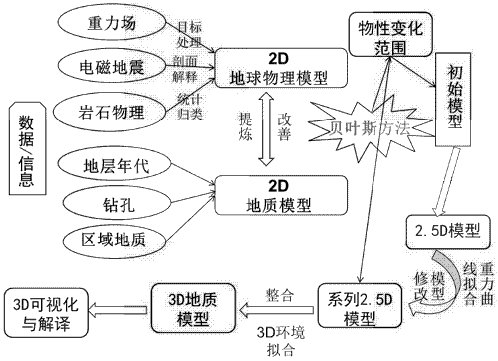
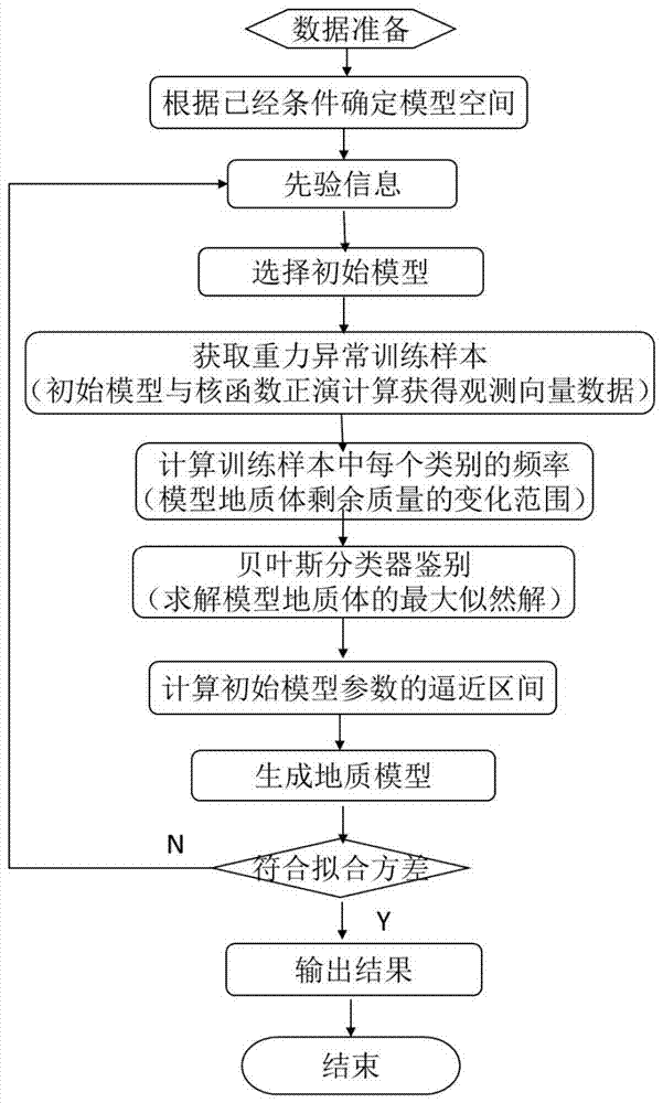
[0050] This embodiment provides a method for obtaining the underground three-dimensional density structure, such as figure 1 As shown, it specifically includes the following steps:
[0051] 1. Define the modeling area: determine the ordinate, abscissa, depth and two-dimensional 2D section spacing of the modeling area.
[0052] This step mainly determines the modeling area according to the target geological area to be studied.
[0053] 2. Preprocessing of prior information:
[0054] like figure 1 As shown, the prior information in this step includes geophysical information and geological information. Geophysical information includes gravity field information, electromagnetic information, seismic information and petrophysical information. Geological information includes stratum age information, drilling data information and regional geological information.
[0055] This step mainly collects the existing information of the target geological area, simplifies the geological un...
Embodiment 2
[0093] This embodiment is mainly used to verify the feasibility of establishing the initial model by the Bayesian inversion method. The specific method is as follows: select the relative density σ of the surrounding rock to be 30kg m -3 Carry out forward modeling experiments on geological bodies of any shape.
[0094] For the convenience of calculation, the triangulation method is used to divide the geological body of any shape into a number of tetrahedrons with very small units, and each tetrahedron divided into the final is approximately regarded as a unit mass sphere. The coordinates (x, y, z) of the center point and the area of the triangle are used to calculate the volume of each tetrahedron, and then multiplied by the density. The calculation method of the gravity value of each tetrahedron is equivalent to the calculation of the sphere. According to Newton's law of universal gravitation, the calculation formula of the gravity value is:
[0095]
[0096] Among them...
Embodiment 3
[0099] This embodiment is an application example, specifically applying the method for obtaining the underground three-dimensional density structure provided in Embodiment 1 to actual geological exploration.
[0100] The Nihe Iron Mine was discovered for the first time in May 2007 by the Anhui Provincial Geological Survey Institute under the guidance of the porphyrite iron ore metallogenic model and the theory of large-scale ore-concentrated areas, using drilling to verify gravity and magnetic anomalies. The Nihe iron deposit is located on the northwest margin of the Luzong volcanic rock basin in Anhui Province, on the Luohe-Huangtun north-east mineralization belt. It is 3km away from the Luohe Iron Deposit in the southwest and 13km away from the Longqiao Iron Deposit in the northeast. It has the same ore-forming geological conditions as the Luohe Iron Deposit. The strata in the Nihe mining area are mainly the Cretaceous Zhuanqiao Formation (K 1 zh) and Cretaceous Shuangmiao ...
PUM
 Abstract
Description
Claims
Application Information
 - R&D
- Intellectual Property
- Life Sciences
- Materials
- Tech Scout
- Unparalleled Data Quality
- Higher Quality Content
- 60% Fewer Hallucinations
Browse by: Latest US Patents, China's latest patents, Technical Efficacy Thesaurus, Application Domain, Technology Topic, Popular Technical Reports.
© 2025 PatSnap. All rights reserved.Legal|Privacy policy|Modern Slavery Act Transparency Statement|Sitemap|About US| Contact US: help@patsnap.com


