
Calculation method for design longitudinal shrinking slope of ladder-pool debris flow drainage groove and application
A drainage channel and longitudinal gradient technology, which is applied in the field of longitudinal gradient calculation for the design of a step-deep pool structure type debris flow drainage channel, can solve the problems such as the inability to use debris flow channels and reduce the longitudinal slope of debris flow segmented discharge.
- Summary
- Abstract
- Description
- Claims
- Application Information
AI Technical Summary
Problems solved by technology
Method used
Image

Examples
Embodiment 1
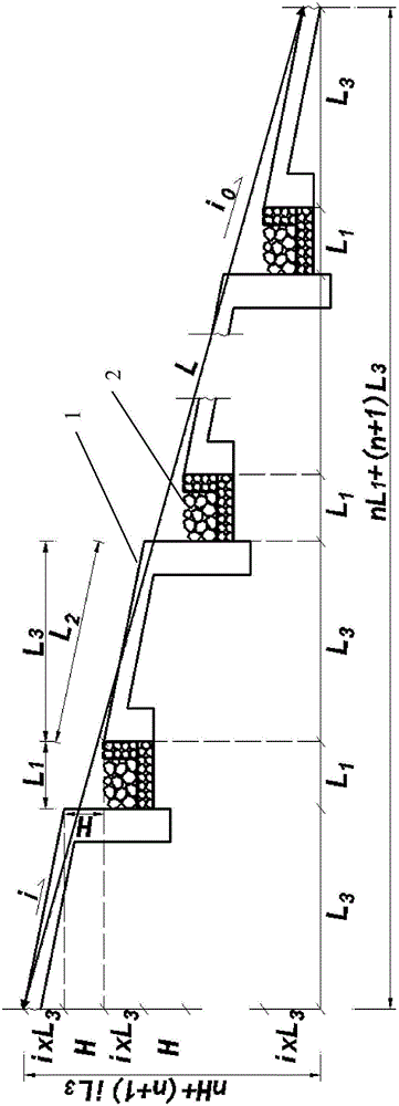
[0049] Such as figure 1 shown. A debris flow ditch is located in the northwest of Mianzhu City, on the left bank of the Mianyuan River. It is a typical representative of debris flow ditch with multiple sources, large gradient and small watershed after the earthquake. Groove area: 1.36km 2 ; Main ditch length: 2.59km; highest point elevation: 1980m; ditch mouth elevation: 960m; relative height difference: 1020m; average vertical gradient: 625‰. Before the earthquake, the ditch was a mountain torrent ditch. After the 5.12 earthquake, the middle and upper mountain body produced a collapse debris flow, which accumulated in the ditch and formed a debris flow under the action of rainfall. From June 2008 to September 2011, a total of 5000m 3 More than 10 times of the above mudslide activities not only buried the Hanwang-Qingping Highway, the lifeline of the ditch mouth, but also blocked the Mianyuan River many times, forming a mudslide barrier lake. After engineering treatment, d...
Embodiment 2
[0059] Such as figure 1 shown. A debris flow ditch is located in the north of Qingpingchang Town in the northwest mountainous area of Mianzhu City, Sichuan Province. In terms of landform, it belongs to tectonic erosion cutting steep low-middle mountain landform, slope and gully landform. The watershed generally extends east-west, the main ditch is in the shape of "7", the cross-section is a combination of "V" and "U", and the catchment area is 7.81km 2 , the total length of the main ditch is 3.25km, the lowest point in the basin is located at the mouth of the ditch at an altitude of 883m, and the highest peak is located at Dingziya of Jiuding Mountain in the eastern part of the watershed, with an altitude of 2402m and a relative height of 1519m. The average longitudinal slope of the trench bed is 458.5‰. There have been many large-scale debris flows in the ditch, which pose a great threat to Qingping Township.
[0060] In order to effectively guide debris flow and reduce...
PUM
 Abstract
Description
Claims
Application Information