Wind field data based automatic trough line drawing method in computer weather software

An automatic drawing and computer technology, which is applied in calculation, electrical digital data processing, special data processing applications, etc., can solve the problems of inaccurate and imperfect automatic analysis of groove lines

Active Publication Date: 2015-09-30
PLA UNIV OF SCI & TECH
View PDF2 Cites 17 Cited by
  • Summary
  • Abstract
  • Description
  • Claims
  • Application Information

AI Technical Summary

Problems solved by technology

[0005] Purpose of the invention: The technical problem to be solved by this invention is to propose a method for automatically drawing slot lines based on wind field data in computer meteorological software in view of the inaccurate and imperfect automatic analysis of slot lines at present

Method used


Image

  • Wind field data based automatic trough line drawing method in computer weather software
  • Wind field data based automatic trough line drawing method in computer weather software
  • Wind field data based automatic trough line drawing method in computer weather software

Examples


Embodiment 1

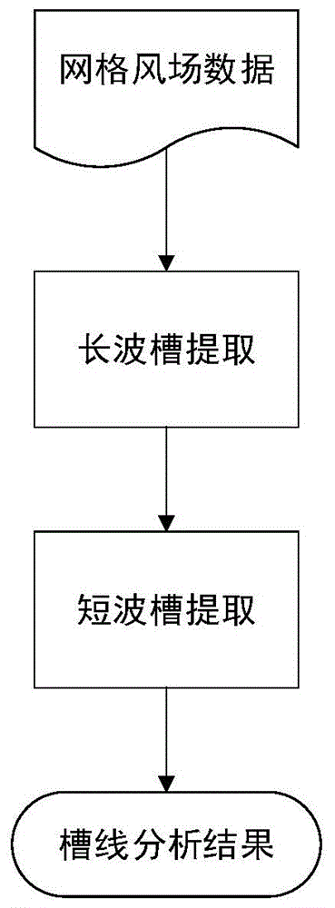
[0259] This embodiment includes long-wave slot extraction and short-wave slot extraction, and its processing flow chart is as follows figure 1 As shown, the whole method is divided into two main steps of long-wave groove extraction and short-wave groove extraction, and the main process of the embodiment part is introduced respectively below.

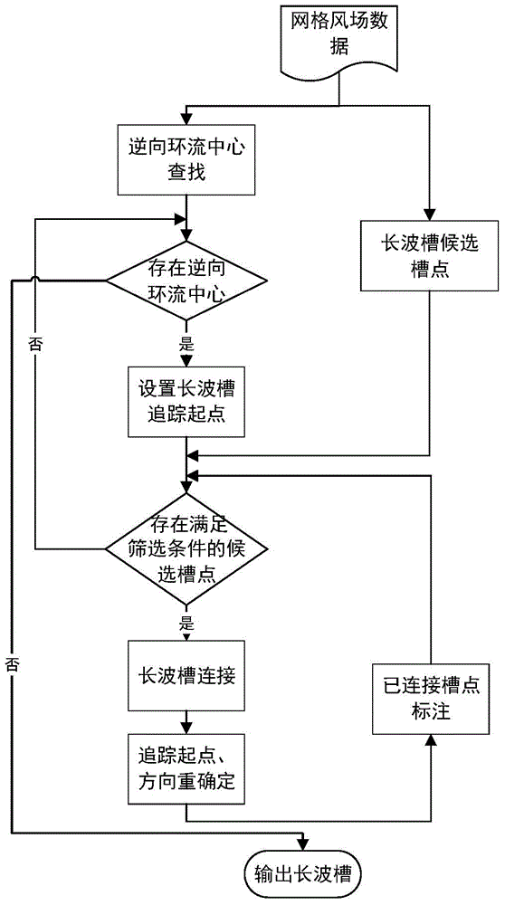
[0260] 1. Long wave trough extraction

[0261] Firstly, extract the wind field data, intercept N 0°---N 60°, E60°---E180° including the data of my country's region to draw a wind field map, as shown in Figure 4a , Figure 4b shown. Figure 4a The results are plotted for the 500hpa wind vector at 00:00 on May 1, 2006. Figure 4b In the middle is the drawing result of the wind vector at 00:00 on May 2, 2006 at 500hpa. select Figure 4a The data at 500hpa at 00:00 on May 1, 2006 were further processed.

[0262] Follow step 11 to extract the reverse circulation center, such as Figure 5 As shown in , the black dot is the extracted re...


PUM


Abstract

The invention discloses a wind field data based automatic trough line drawing method in computer weather software to realize automatic recognition of weather trough lines in a weather map. The method comprises steps as follows: generation of long-wave troughs: extracting reverse circulation centers of wind field grid data, searching candidate long-wave trough points in the data, tracking and connecting the trough points with the reverse circulation centers serving as starting points, and extracting the long-wave troughs; generation of short-wave troughs: performing vorticity and angle deflection screening on the wind field grid data, extracting candidate short-wave trough points, after screening in combination with the candidate long-wave trough points, performing minimum spanning tree clustering on rest candidate short-wave trough points, performing curve fitting on candidate trough point sets in each generating class, and extracting the short-wave troughs.

Description

technical field [0001] The invention relates to automatic analysis of meteorological trough lines, belonging to the field of automatic analysis in meteorological analysis, in particular to a method for automatically drawing trough lines based on wind field data in computer meteorological software. Background technique [0002] A weather map is a special map filled with meteorological observation records at the same time in various places, which describes the weather conditions in a certain area at a certain moment. In daily meteorological operations, two types of surface weather maps (referred to as surface maps) and isobaric surface maps (referred to as upper-air maps) need to be drawn. The surface weather map is filled with various meteorological elements on the ground and extracted phenomena, such as temperature, humidity, wind direction, wind speed, sea level air pressure, rain, snow, fog and cloud height and cloud shape. The isobaric surface diagram is used to represen...

Claims


Application Information

Patent Timeline
Patent Type & Authority Applications(China)
IPC IPC(8): G06F17/50
Inventor 李骞代曦顾大权夏士明
Owner PLA UNIV OF SCI & TECH
Why Eureka
Try Eureka