Microwave remote sensing image based forest type identification method

A remote sensing image and type identification technology, applied in the field of remote sensing and forest type identification, can solve the problems of cumbersome operation process and inability to accurately identify forest types.

Inactive Publication Date: 2015-10-28
NORTHEAST FORESTRY UNIVERSITY
View PDF3 Cites 15 Cited by
  • Summary
  • Abstract
  • Description
  • Claims
  • Application Information

AI Technical Summary

Problems solved by technology

[0007] The purpose of the present invention is to solve the problem that the prior art cannot accurately identify the forest type and the operation process is cumbersome

Method used


Image

  • Microwave remote sensing image based forest type identification method
  • Microwave remote sensing image based forest type identification method
  • Microwave remote sensing image based forest type identification method

Examples


Embodiment Construction

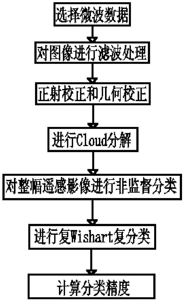
[0038] Illustrate the specific embodiment of the present invention in conjunction with accompanying drawing, method of the present invention comprises the following steps:

[0039] 1. Select the microwave data, and use the remote sensing data of the fully polarized Radarsat-2 image in the c-band as the remote sensing data source.

[0040] 2. Select the exquisite polarization Lee filtering method with a filter window of 5*5 size, and use ProSARpro software to process the full polarization SAR data to be classified to eliminate noise and suppress coherent speckle.

[0041] 3. Perform orthorectification on the fully polarimetric SAR image after filtering, use custom RPC control point correction and use ENVI for geometric registration.

[0042] 4. Decompose the corrected data Cloud, specifically including the following steps:

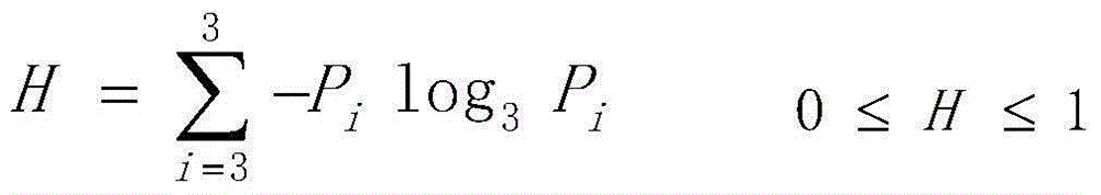
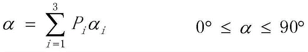
[0043] 1) First extract the polarization scattering matrix [S] in the filtered multi-polarization SAR image, and obtain the coherence matrix [T] according...


PUM


Abstract

A microwave remote sensing image based forest type identification method relates to a forest type identification method. The invention aims to solve the problem that the conventional method cannot identify the forest type precisely and has a complicated operation process. The method comprises a first step of inputting an image and preprocessing the image; a second step of extracting a coherence matrix of the preprocessed complete polarization SAR image; a third step of performing unsupervised classification on the whole remote sensing image by use of an H-alpha / Wishart classification method and an H-A-alpha / Wishart classification method so as to extract an experimental region forest part; and a fourth step of using a result of the unsupervised classification of the third step as an original input data, and performing complex Wishart supervised classification by use of a maximum likelihood classifier, so as to realize identification of the forest type. According to the method, the classification method is simple and the classification accuracy is high.

Description

technical field [0001] The invention relates to a method for identifying forest types, in particular to a method for identifying forest types based on microwave remote sensing images, and belongs to the technical field of remote sensing. Background technique [0002] Synthetic aperture radar is an all-weather and all-weather space microwave remote sensing imaging radar, which has a certain penetration ability to ground objects. Compared with optical remote sensing, it can penetrate clouds and realize surface observation is not easily affected by weather. Obtain the surface object image under the surface coverage, so that the full polarization SAR remote sensing image provides more information than the optical remote sensing image. In recent years, synthetic aperture radar has been widely used in many fields such as earth resource survey, flood disaster monitoring, vegetation species identification, ocean monitoring and other technologies. [0003] The full polarization SAR ...

Claims


Application Information

Patent Timeline
Patent Type & Authority Applications(China)
IPC IPC(8): G06K9/00G06K9/62
CPCG06V20/188G06F18/2413
Inventor 李明泽付瑜范文义
Owner NORTHEAST FORESTRY UNIVERSITY
Why Eureka
Try Eureka