Polarized SAR terrain classification method based on Gauss filtering and PSO

A Gaussian filtering and ground object classification technology, applied in the field of image processing, can solve the problem of low classification effect, and achieve the effect of improving the classification accuracy

Active Publication Date: 2015-11-18
XIDIAN UNIV
View PDF2 Cites 6 Cited by
  • Summary
  • Abstract
  • Description
  • Claims
  • Application Information

AI Technical Summary

Problems solved by technology

In addition to single-pixel information, polarimetric SAR ground object information also has spatial neighborhoo...

Method used


Image

  • Polarized SAR terrain classification method based on Gauss filtering and PSO
  • Polarized SAR terrain classification method based on Gauss filtering and PSO
  • Polarized SAR terrain classification method based on Gauss filtering and PSO

Examples


Embodiment 1

[0026] Example 1, classifying polarimetric SAR images in Germany.

[0027] The pseudo-color map of the polarimetric SAR image in Germany is shown in 2(a), and its size is 1300×1200;

[0028] The marker map of the polarized SAR image in Germany is shown in 2(b);

[0029] by false color figure 2 (a) The size of the obtained polarimetric SAR image is 1300×1200, from the marker figure 2 Randomly select 1% of the marked samples in (b) as training samples to obtain the category and location of the training samples, and use the remaining 99% of the labeled samples as test samples to obtain the category and location of the test samples. The total number of categories C is 3.

[0030] Using the existing single-pixel-based method SVM, according to figure 2 The polarimetric SAR data of (a) and figure 2 The labeled map in (b) is learned to classify the polarimetric SAR images in Germany, and the results are shown in 2(c).

[0031] Utilize the method of the present invention to cl...

Embodiment 2

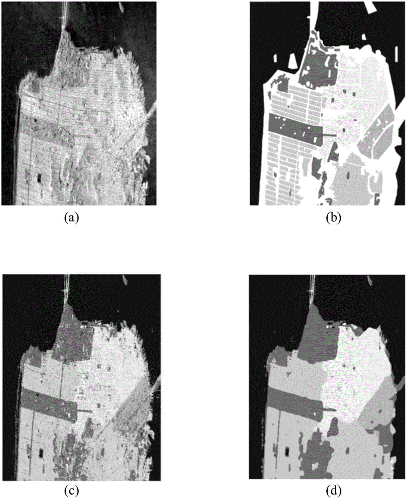
[0051] Example 2, classifying polarimetric SAR images in the San Francisco area.

[0052] The pseudo-color map of the polarimetric SAR image in San Francisco is shown in 3(a), and its size is 1800×1380;

[0053] The marker map of the polarimetric SAR image in the San Francisco area is shown in 3(b);

[0054] by false color image 3 (a) The size of the obtained polarimetric SAR image is 1800×1380, from the marker image 3 Randomly select 1% of the marked samples in (b) as training samples to obtain the category and location of the training sample, and use the remaining 99% of the labeled samples as test samples to obtain the category and location of the test sample. The total number of categories C is 5.

[0055] Using the existing single-pixel-based method SVM, according to image 3 The polarimetric SAR data of (a) and image 3 The labeled map in (b) is learned to classify the polarimetric SAR images in the San Francisco area, and the results are shown in 3(c).

[0056] U...

Embodiment 3

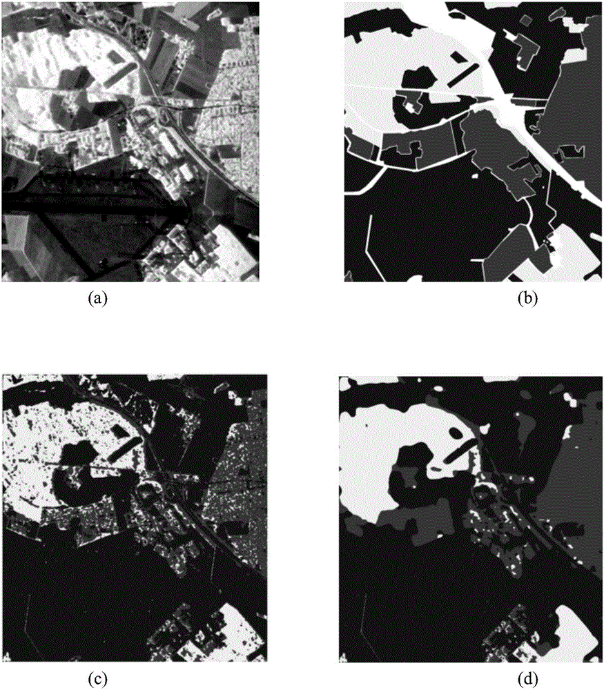
[0072] Example 3, classifying polarimetric SAR images in the Netherlands.

[0073] The pseudo-color map of the polarimetric SAR image in the Netherlands is shown in 4(a), and its size is 750×1024;

[0074] The marked map of the polarimetric SAR image in the Netherlands is shown in 4(b);

[0075] by false color Figure 4 (a) The size of the obtained polarimetric SAR image is 750×1024, from the marker Figure 4 Randomly select 10% of the marked samples in (b) as training samples to obtain the category and location of the training sample, and use the remaining 90% of the labeled samples as the test sample to obtain the category and location of the test sample. The total number of categories C is 15.

[0076] Using the existing single-pixel-based method SVM, according to Figure 4 The polarimetric SAR data of (a) and Figure 4 The labeled map in (b) is learned to classify polarimetric SAR images in the Netherlands, and the results are shown in 4(c).

[0077] Utilize the metho...


PUM


Abstract

The invention discloses a polarized SAR terrain classification method based on Gauss filtering and SPO, and mainly solves the problem that a present classification method based on single pixel point is low in classification precision. The method comprises the steps that related information of a polarized SAR image to be classified and a result of classifying the polarized SAR image in the present single pixel point method are input to construct a class diagram; the class diagram is divided into sub class diagrams, objective functions are constructed for the sub class diagrams respectively, the objective functions are optimized in the PSO algorithm to obtain an optimal variance; the optimal variance is used to establish a Gauss filter; Gauss filtering is carried out on the sub class diagrams to obtain classification result of the each sub image; and the classification results of all the sub images are merged to obtain a classification result of the whole polarized SAR image to be classified. Thus, the precision of polarized SAR terrain classification is improved, and the method can be applied to terrain classification and object identification.

Description

technical field [0001] The invention belongs to the technical field of image processing, and in particular relates to a method for classifying ground objects in polarimetric synthetic aperture radar SAR images, which can be used for classification of ground objects and target recognition. Background technique [0002] Polarized SAR is an advanced SAR system that describes the observed land cover and targets by transmitting and receiving polarized radar waves. Polarized SAR can obtain richer surface feature information. [0003] One of the important research issues of polarimetric SAR image interpretation is the classification of polarimetric SAR ground features. The purpose of polarimetric SAR ground object classification is to use the measurement data obtained by airborne or spaceborne polarimetric sensors to divide the ground objects with similar properties into one category, specifically to determine the category corresponding to each pixel of the polarimetric SAR image ...

Claims


Application Information

Patent Timeline
IPC IPC(8): G06K9/62G06K9/66G06T5/00
CPCG06T5/00G06T2207/10044G06T2207/20172G06V30/194G06F18/24
Inventor 焦李成李玲玲曾杰马文萍张丹屈嵘侯彪王爽马晶晶尚荣华
Owner XIDIAN UNIV
Why Eureka
Try Eureka