Floating car data based private car travel data integration method
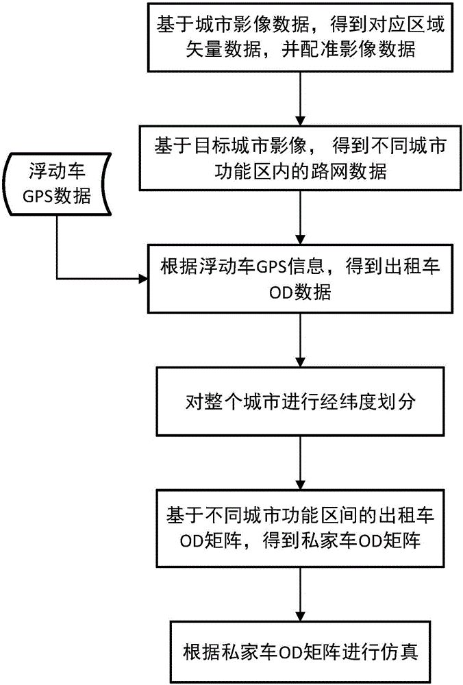
A technology for floating car data and private cars, applied in the field of in-vehicle social networking, can solve the problems of poor timeliness and high consumption, and achieve the effect of large amount of data, overcoming implementation difficulties, and solid guarantee.
- Summary
- Abstract
- Description
- Claims
- Application Information
AI Technical Summary
Problems solved by technology
Method used
Image
Examples
Embodiment 1
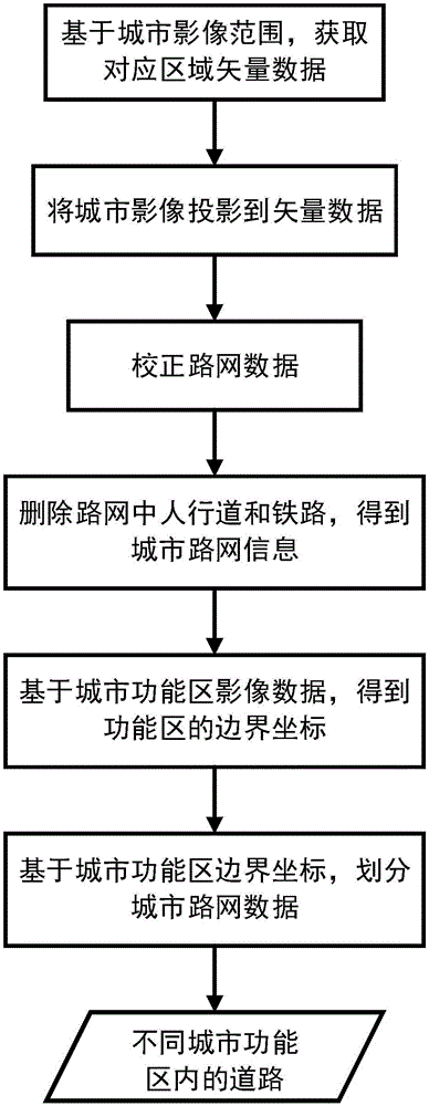
[0054] Example 1: Road network generation method based on urban functional areas
[0055] This example involves a road network generation method based on urban functional areas such as figure 2 , including the following steps:
[0056] (11) According to the image range of Beijing, download the corresponding vector data from the OpenStreetMap server, and the vector data includes road vector data.
[0057] (12) Project the images of Beijing's urban functional areas to the vector data obtained in step (11), the specific process is as follows:
[0058] 1) Use ArcMap to embed the coordinate system of vector data for the image of urban functional areas;
[0059] 2) Project the point coordinates of the four corners of the urban functional area image into the coordinate system of the target vector data, and set the latitude and longitude coordinates for the four corner points;
[0060] 3) Find the point where the image of the urban functional area does not match the vector data, and...
Embodiment 2
[0066] Embodiment 2: Based on the floating car OD data, the generation method of private car OD matrix in different urban functional areas.
[0067] This example involves the generation method of the private car OD matrix between different functions, the process is as follows:
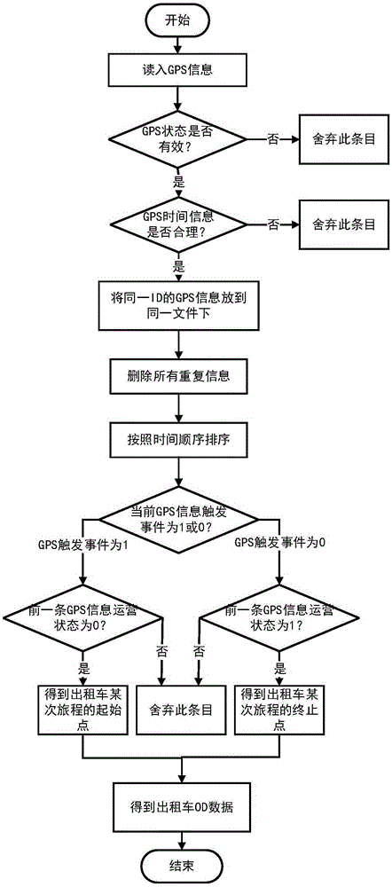
[0068] (21) Store and read the historical data of the floating car, preprocess the taxi GPS information in the GPS data, and obtain the OD data set of the floating car;
[0069] The present embodiment adopts the GPS data of 12000 taxis of 30 days altogether in December, 2012 in Beijing, image 3 Shown is the floating car data OD data processing method, the specific steps are as follows:
[0070] The format of the taxi GPS data set in this example is shown in Table 1 below:
[0071] serial number
name
note
1
6 characters
2
trigger event
0=empty vehicle, 1=passenger, 2=arm, 3=disarm, 4=other
3
operating status
0=empt...
Embodiment 3
[0096] Example 3: Using private car OD matrices in different functional areas to simulate and generate private car travel data for the entire city
[0097] A method for generating a private car data set based on floating car data, specifically comprising the following steps:
[0098] (31) Using SUMO / od2trips, the private car OD matrix between different functional areas is transformed into different private car journey information.
[0099] (32) Use SUMO / duarouter to convert the journey information obtained in step (31) into the route information of private cars running in the city.
[0100] (33) Based on different path information, use SUMO / sumo to perform simulation.
PUM
 Abstract
Description
Claims
Application Information
 - R&D
- Intellectual Property
- Life Sciences
- Materials
- Tech Scout
- Unparalleled Data Quality
- Higher Quality Content
- 60% Fewer Hallucinations
Browse by: Latest US Patents, China's latest patents, Technical Efficacy Thesaurus, Application Domain, Technology Topic, Popular Technical Reports.
© 2025 PatSnap. All rights reserved.Legal|Privacy policy|Modern Slavery Act Transparency Statement|Sitemap|About US| Contact US: help@patsnap.com


