Laser-point-cloud-based urban road identification method and apparatus

A laser point cloud, road recognition technology, applied in the field of intelligent transportation, can solve the problems of low object recognition efficiency, large error, low efficiency of road model construction, etc., to improve the construction efficiency and accuracy, and improve the recognition efficiency and accuracy. Effect

Active Publication Date: 2015-12-23
BAIDU ONLINE NETWORK TECH (BEIJIBG) CO LTD
View PDF5 Cites 71 Cited by
  • Summary
  • Abstract
  • Description
  • Claims
  • Application Information

AI Technical Summary

Problems solved by technology

[0004] In the above scheme, the road surface model corresponding to the laser point cloud is constructed by randomly setting the initial input threshold, which leads to low construction efficiency and large error of the road surface model, which leads to low object recognition efficiency and large error

Method used


Image

  • Laser-point-cloud-based urban road identification method and apparatus
  • Laser-point-cloud-based urban road identification method and apparatus
  • Laser-point-cloud-based urban road identification method and apparatus

Examples


Embodiment 1

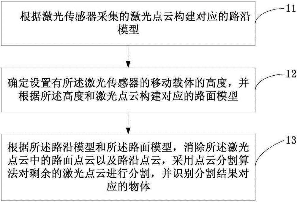
[0023] figure 1 It is a schematic flowchart of a laser point cloud-based urban road recognition method provided by Embodiment 1 of the present invention. This embodiment is applicable to the situation of identifying objects contained in urban roads based on laser point clouds. see figure 1 The method for identifying urban roads based on laser point clouds provided in this embodiment specifically includes the following:

[0024] S11. Construct a corresponding roadside model according to the laser point cloud collected by the laser sensor.

[0025] In this embodiment, the laser sensor can be a laser radar arranged on a mobile carrier, the mobile carrier can usually be a vehicle, and the laser point cloud can be a feature point set of the environment where the mobile carrier is located, including the coordinates and reflectance of each feature point, The reflectivity can be an integer from 0 to 255.

[0026] Exemplarily, the laser radar collects the laser point cloud, and the...

Embodiment 2

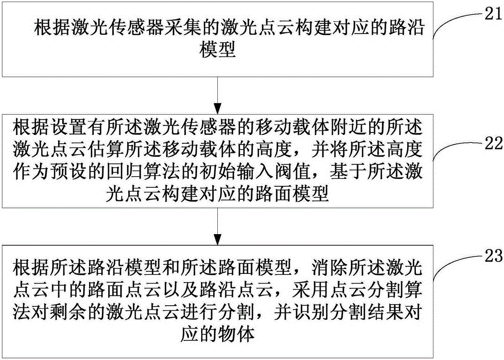
[0034] This embodiment provides a new urban road recognition method based on laser point cloud on the basis of the above embodiments, and this method further limits the construction methods of the roadside model and the road surface model. figure 2 It is a schematic flowchart of a laser point cloud-based urban road recognition method provided by Embodiment 2 of the present invention. see figure 2 The method for identifying urban roads based on laser point clouds provided in this embodiment specifically includes the following:

[0035] S21. Construct a corresponding roadside model according to the laser point cloud collected by the laser sensor.

[0036] Optionally, constructing a corresponding roadside model based on the laser point cloud collected by the laser sensor may specifically include: using a corner point detection algorithm to identify the laser point cloud to obtain the roadside corner corresponding to the laser point cloud; The curb corner points of the road cu...

Embodiment 3

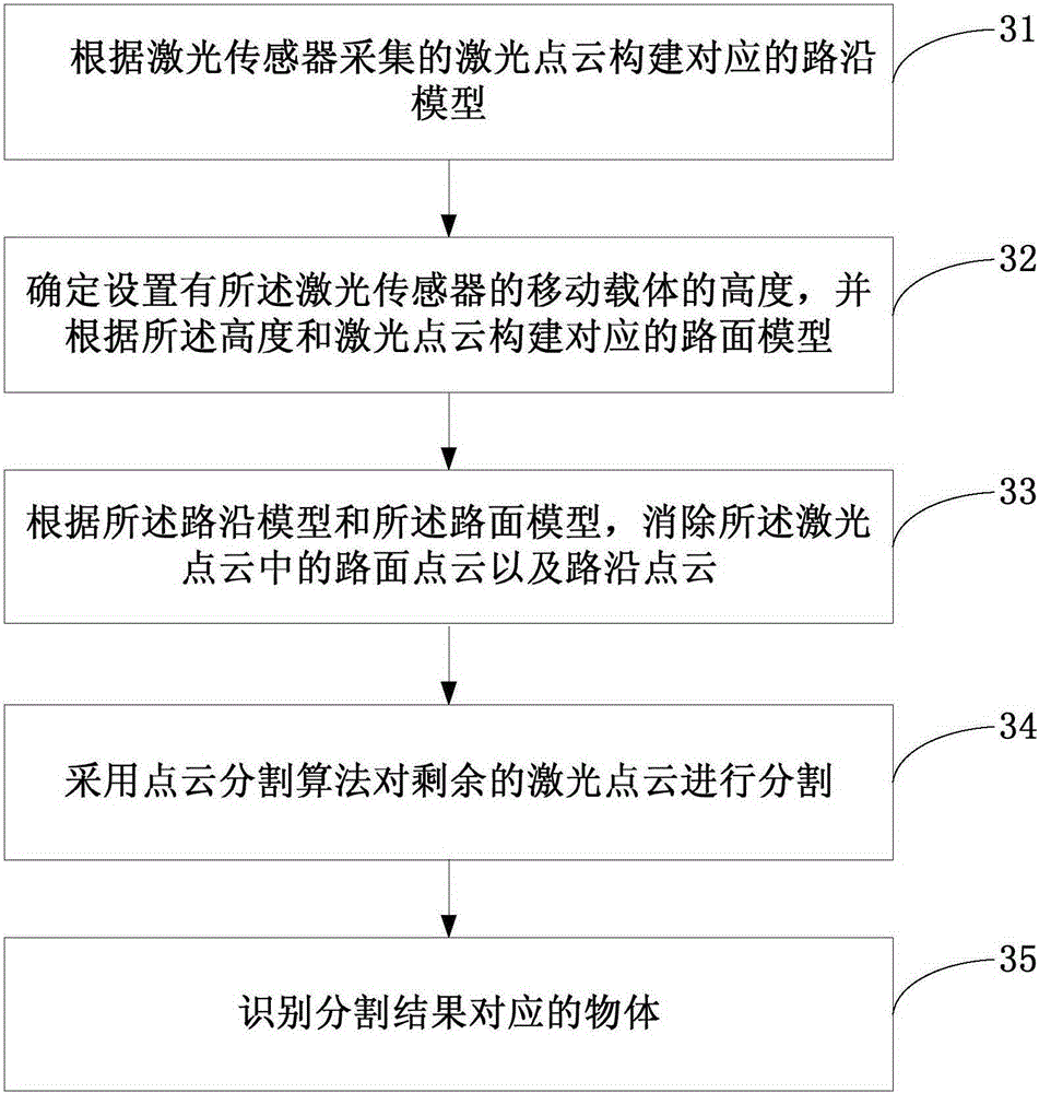
[0047] Based on the above-mentioned embodiments, this embodiment provides another method for identifying urban roads based on laser point clouds, which further limits the point cloud segmentation method. image 3 It is a schematic flowchart of a laser point cloud-based urban road recognition method provided by Embodiment 3 of the present invention. see image 3 The method for identifying urban roads based on laser point clouds provided in this embodiment specifically includes the following:

[0048] S31. Construct a corresponding roadside model according to the laser point cloud collected by the laser sensor.

[0049] S32. Determine the height of the mobile carrier provided with the laser sensor, and construct a corresponding road surface model according to the height and the laser point cloud.

[0050] S33. According to the roadside model and the road surface model, eliminate the road surface point cloud and the roadside point cloud in the laser point cloud.

[0051] Exemp...


PUM


Abstract

The embodiment of the invention discloses a laser-point-cloud-based urban road identification method and apparatus. The method comprises: a corresponding road edge model is constructed according to laser point clouds collected by a laser sensor; a height of a mobile carrier with the laser sensor is determined and a corresponding road surface model is constructed based on the height and the laser point; and according to the road edge model and the road surface model, a road surface point cloud and a road edge point cloud in the laser point cloud are eliminated, the rest of laser point clouds are segmented by using a point cloud segmentation algorithm, and an object corresponding to the a segmentation result is identified. The height of the mobile carrier is estimated based on the laser point cloud and the road surface model corresponding to the laser point cloud is constructed by using the height, so that the construction efficiency and accuracy of the road surface model are improved. Therefore, the identification efficiency and accuracy of the corresponding object are improved.

Description

technical field [0001] The embodiments of the present invention belong to the technical field of intelligent transportation, and relate to a method and device for identifying urban roads based on laser point clouds. Background technique [0002] Through the laser sensor installed in the mobile carrier (such as a vehicle) to perceive the surrounding environment and process the sensory information, the information of the environment where the mobile carrier is located, such as the lane, road range, obstacle position, etc., is obtained, which is the laser point cloud technology. [0003] In the prior art, road information is extracted mainly by constructing a roadside model based on the laser point cloud, and by randomly setting the initial input threshold of the regression algorithm to construct a road surface model corresponding to the laser point cloud; Laser point cloud clusters and obtain objects corresponding to laser point cloud clusters through point cloud segmentation ...

Claims


Application Information

Patent Timeline
Patent Type & Authority Applications(China)
IPC IPC(8): G06T17/00G06K9/00G06V20/64G06V10/147G06V10/764G06V20/58
CPCG06T17/00G06V20/64G06V20/588G06V20/58G06V10/147G06V10/462G06V10/757G06V10/764G06F18/00G06F18/2132G06T2207/10028G06T2207/30256G06V20/56G06V20/39G06F18/2411G06T15/205G06T17/05
Inventor 姜雨晏阳
Owner BAIDU ONLINE NETWORK TECH (BEIJIBG) CO LTD
Why Eureka
Try Eureka