Method and apparatus for establishing fault model based on spatial fault polygon

A space fault and polygon technology, applied in the field of reservoir description, can solve the problems of manual intervention and modification, which require a large workload and time-consuming

Active Publication Date: 2016-01-06
PETROCHINA CO LTD
View PDF10 Cites 22 Cited by
  • Summary
  • Abstract
  • Description
  • Claims
  • Application Information

AI Technical Summary

Problems solved by technology

[0011] The present invention provides a method and device for establishing a fault model based on spatial fault polygons, so as to at least solve the faul...

Method used


Image

  • Method and apparatus for establishing fault model based on spatial fault polygon
  • Method and apparatus for establishing fault model based on spatial fault polygon
  • Method and apparatus for establishing fault model based on spatial fault polygon

Examples


Embodiment 1

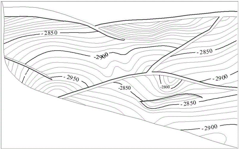
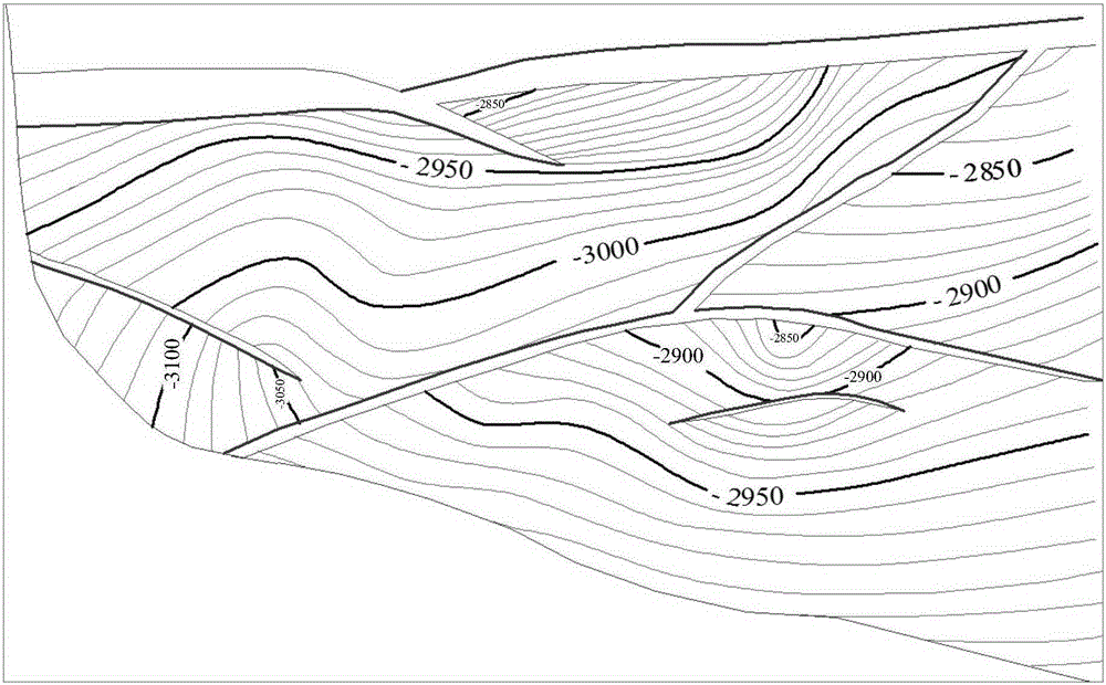
[0112] Taking the A oil field located in the Jidong Depression of the Bohai Bay Basin in eastern my country as an example, the studied target layer is formed under a tensional environment, and the faults explained in the selected modeling range are all normal faults, to test the present invention. Effectiveness of a modeling approach for normal faults. The simulation calculation process of this embodiment is as follows Figure 8A to Figure 11B As shown, the construct modeled in Es 3 1 It was carried out on the basis of the result map of the three-layer structure at the top of oil group I, II, and III, and the structural inheritance is good.

[0113] Figures 8A to 8C Respectively show A oilfield Es 3 1 The preliminary model of structural space on the top surface of oil group I, II, and III is mainly used in modeling to check whether there is a trend problem in the structural surface and to provide the structural surface for fault line projection calculation by traditional ...

Embodiment 2

[0118] Taking the B oilfield located in the western southern part of the Qaidam Basin in western my country as an example, the target layer studied was formed in a compression environment, and the faults interpreted within the modeling range of the selected well area are all reverse faults to test Effectiveness of the modeling method of the present invention for reverse faults. The simulation calculation process of this embodiment is as follows Figure 12A to Figure 15B As shown, the construct modeled in N 2 1 Based on the result map of the three-layer structure on the top surface of reservoir III, IV and V oil formations.

[0119] Figures 12A to 12C Respectively show the B oil field N 2 1 The preliminary model of structural space on the top surface of oil group III, IV and V is mainly used in modeling to check whether there is a trend problem in the structural plane and to provide a structural plane for fault line projection calculation by traditional modeling methods. ...


PUM


Abstract

The invention discloses a method and an apparatus for establishing a fault model based on a spatial fault polygon. The method comprises: reading a structural contour map and fault polygon data; determining the type of the fault polygon according to the fault polygon data; separating the fault polygon into a hanging wall fault line and a footwall fault line according to the type; calculating coordinates of an intersection point between the hanging wall fault line and a contour line and an intersection point between the footwall fault line and the contour line, and obtaining three-dimensional intersection point coordinates by taking a corresponding elevation value of the contour line as a z value of the intersection point; calculating an elevation value of each vertex of the fault polygon by utilizing the three-dimensional intersection point coordinates to obtain three-dimensional coordinates of each vertex; for each fault line, performing neighbor smoothing filtering on the evaluation values of the vertex and the intersection point on the fault line to obtain spatial trajectory coordinates of the fault polygon; correcting the spatial trajectory coordinates to obtain coordinate data; and performing fault modeling according to the coordinate data. The three-dimensional data of the fault polygon is obtained quickly and accurately, and an accurate model is established, so that the workload of later correction is reduced.

Description

technical field [0001] The invention relates to the field of reservoir description, in particular to a method and device for establishing a fault model based on spatial fault polygons. Background technique [0002] 3D geological modeling technology plays an extremely important role in the exploration and development of oil and gas fields and fine description of oil and gas reservoirs. The establishment of 3D geological models is an important means in the fields of earth science and oil and gas field development, and the establishment of fault models is extremely important. one ring. [0003] There are many methods for fault modeling in actual work. At present, the mainstream method of fault modeling is to rely on commercial software in the depth domain, such as RMS (Reservoir Modeling Software), Petrel or other similar modeling software. According to the original data used in fault modeling, there are mainly the following methods: [0004] (1) Carry out fault modeling afte...

Claims


Application Information

Patent Timeline
IPC IPC(8): G06T17/05
Inventor 刘应如曹正林杜斌山段天向张婷静陈更新
Owner PETROCHINA CO LTD
Why Eureka
Try Eureka