Supercharge Your Innovation With Domain-Expert AI Agents!

A Method of Urban Aerodynamic Roughness Inversion Based on SAR Data

An aerodynamic and roughness technology, applied in the fields of electrical digital data processing, special data processing applications, instruments, etc., can solve the problem that the spatial and temporal distribution characteristics of urban aerodynamic roughness cannot be effectively described, and the aerodynamics of urban areas are not considered. Roughness direction and scale characteristics, ignoring the high heterogeneity of the spatial distribution of roughness elements on the underlying surface of the city, etc.

Inactive Publication Date: 2018-07-03
中科卫星应用德清研究院 +1
View PDF2 Cites 0 Cited by
  • Summary
  • Abstract
  • Description
  • Claims
  • Application Information

AI Technical Summary

Problems solved by technology

This is currently the most commonly used method, but this method is usually used for mesoscale models and requires very fine classification results when used in urban areas, which is difficult for urban areas with high heterogeneity
The second type of method is to establish a relationship model between the aerodynamic roughness and the backscattering coefficient of the SAR image, but the existing research does not take into account the direction and scale characteristics of the aerodynamic roughness of the urban area, ignoring the urban underlying surface The spatial distribution of roughness elements is highly heterogeneous, so it cannot effectively describe the spatial and temporal distribution characteristics of urban aerodynamic roughness
[0005] It can be seen that the above-mentioned existing urban aerodynamic roughness calculation methods still have deficiencies. How can we create a method that fully considers the highly heterogeneous distribution of roughness elements on the underlying surface in urban areas and combines direction and scale analysis techniques? The aerodynamic roughness inversion method is one of the current important research and development topics

Method used


Image

  • A Method of Urban Aerodynamic Roughness Inversion Based on SAR Data
  • A Method of Urban Aerodynamic Roughness Inversion Based on SAR Data
  • A Method of Urban Aerodynamic Roughness Inversion Based on SAR Data

Examples


Embodiment Construction

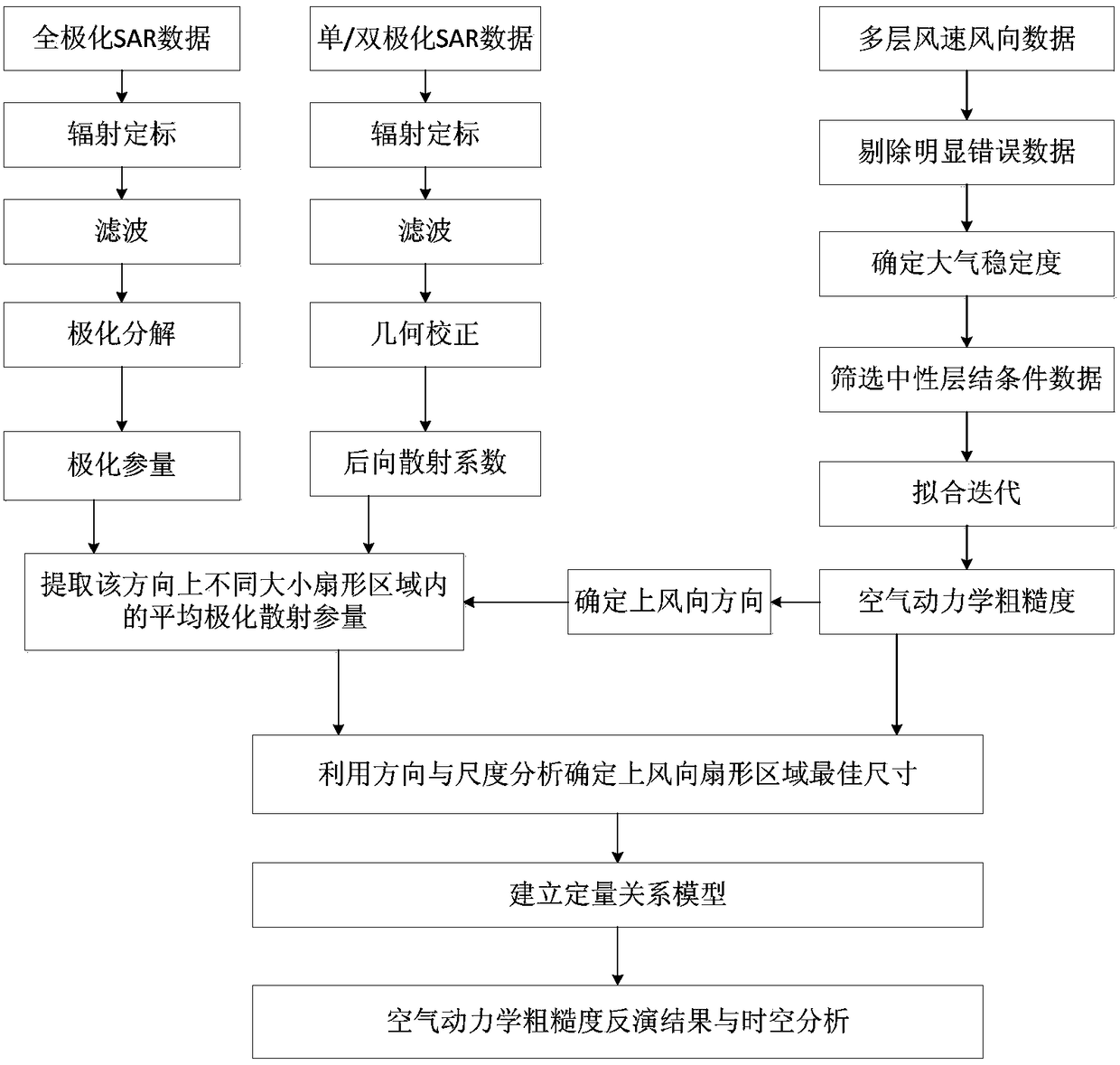
[0036] Aiming at the problems existing in the existing urban aerodynamic roughness inversion methods, the present invention fully considers the characteristics of high heterogeneity of urban underlying surface roughness elements, and proposes an urban area based on SAR data by means of direction and scale analysis techniques. Aerodynamic roughness inversion method. Refer to attached figure 1 As shown, the method specifically includes the following steps:

[0037]Step 1: first process the SAR data, including radiometric calibration, filtering, geometric correction and registration processing of the SAR data, among which, the full polarization SAR data processing also includes the steps of polarization decomposition and polarization parameter extraction. / Dual-polarization SAR data processing also includes the step of backscatter coefficient extraction; then, according to the characteristics of urban areas, select the most representative land types, such as residential areas, h...


PUM


Abstract

The invention discloses an urban aerodynamic roughness inversion method based on SAR data, comprising: the first step: processing the SAR data to extract polarization scattering parameters that can characterize the roughness of the underlying surface; the second step: Process the multi-layer wind speed and direction gradient data measured by the meteorological tower, and calculate the aerodynamic roughness in different directions; the third step: use the direction and scale analysis, according to the correlation between the polarization scattering parameters and the aerodynamic roughness Determine the optimal size of the upwind fan-shaped area; the fourth step: extract the polarization scattering parameters in the optimal upwind fan-shaped area from the SAR image, and establish a quantitative relationship model between it and the urban aerodynamic roughness; Five steps, use the quantitative relationship model established in the fourth step to invert to obtain the urban aerodynamic roughness distribution map. The invention proposes a method for establishing a quantitative relationship model between SAR data and urban aerodynamic roughness, which is suitable for the fine description of roughness characteristics of urban underlying surfaces.

Description

technical field [0001] The invention relates to the technical field of aerodynamic roughness calculation, in particular to an urban aerodynamic roughness inversion method based on SAR data. Background technique [0002] A city is a spatial region with dense population, concentration of social and economic activities and relative concentration of resources. Rapidly increasing artificial targets such as buildings and road networks have greatly changed the roughness characteristics of the surface. Changes in the roughness of the underlying surface affect atmospheric turbulence and micro-meteorology, and change the transmission and diffusion of turbulence and the deposition of atmospheric pollutants. Therefore, the process of urbanization has resulted in a very complex urban boundary layer structure, and the interaction between land and atmosphere in urban areas is one of the current research hotspots. Aerodynamic roughness (aerodynamic roughness)z 0 Defined as the height abov...

Claims


Application Information

Patent Timeline
Patent Type & Authority Patents(China)
IPC IPC(8): G06F17/50
Inventor 张风丽沙敏敏王国军李志坤刘清波邵芸
Owner 中科卫星应用德清研究院
Features
  • R&D
  • Intellectual Property
  • Life Sciences
  • Materials
  • Tech Scout
  • Unparalleled Data Quality
  • Higher Quality Content
  • 60% Fewer Hallucinations
Learn More