Passive microwave remote sensing instant ground surface emitting rate estimation method and device

A passive microwave remote sensing, surface emissivity technology, applied in the field of remote sensing data geoscience parameter inversion, can solve the problems of land surface parameterization inversion error, difficulty and so on

Active Publication Date: 2017-02-01
INST OF REMOTE SENSING & DIGITAL EARTH CHINESE ACADEMY OF SCI
View PDF5 Cites 15 Cited by
  • Summary
  • Abstract
  • Description
  • Claims
  • Application Information

AI Technical Summary

Problems solved by technology

[0004] Atmospheric water vapor, temperature profile, cloud identification, dew at night, and changes in soil moisture in the atmospheric parameters will directly affect the estimation of surface emissivity, and the most direct impact on the change of surface emissivity is due to atmospheric clouds. Covering,

Method used


Image

  • Passive microwave remote sensing instant ground surface emitting rate estimation method and device
  • Passive microwave remote sensing instant ground surface emitting rate estimation method and device
  • Passive microwave remote sensing instant ground surface emitting rate estimation method and device

Examples


Embodiment 1

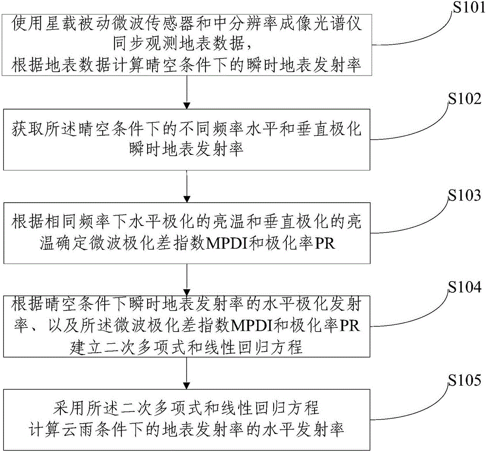
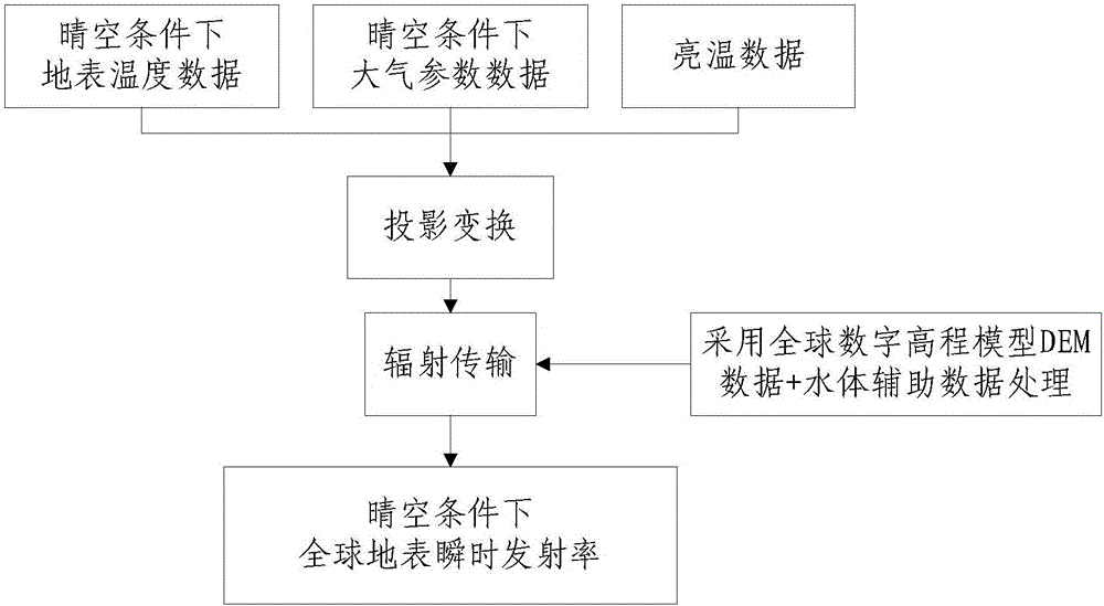
[0124] In the first embodiment, the embodiment of the present invention selects two places in China to conduct emissivity estimation tests at 10.7GHz and 18.7GHz. The ground cover in the test area is mainly grassland (southeast of the Qinghai-Tibet Plateau) and crops (central China). The tested instantaneous surface emissivity distribution map (time 12-08-2006 ascending orbit), using these two areas to test the emissivity prediction ability of PR and MPDI. The data format is EASE-GRID (Equal-Area Scalable EarthGrid) grid.

[0125] The effective emissivity sampling points for the ascending orbit on August 12, 2008 were 505 and 157 respectively. Both PR and MPDI polarization parameters are used to establish the emissivity prediction equations of formula 4.15 (quadratic polynomial) and 4.16 (multiple / univariate linear regression). The root mean square error (RMSE) of the emissivity obtained by the equation and its horizontal polarization emissivity is shown in Table 1. It can be s...

Embodiment 2

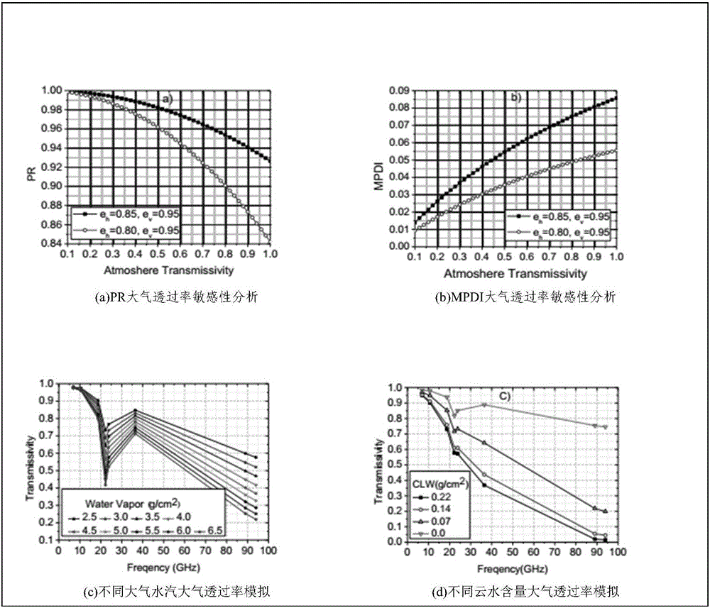
[0134] The second embodiment is the result of calculating the vertical and polarized emissivity of the global surface emissivity at 36.5 GHz by using the above method. The result shows the expected spatial structure. The V polarization is greater than the H polarization, which is in line with the description of the model. The polarization difference in ice-covered areas is large, such as the Antarctic continent and the snow and ice surface of Greenland. This is due to the scattering on the ice and snow surface. The impact of the role. The same phenomenon is also shown in deserts and semi-arid areas. The Qinghai-Tibet Plateau has low emissivity in both polarizations, and the same phenomenon also occurs in deserts and semi-arid areas, such as the Sahara Desert and central Australia.


PUM


Abstract

The invention provides a passive microwave remote sensing instant ground surface emitting rate estimation method and device. The method or device comprises a step or a device for calculating the instant ground surface emitting rate under the clear sky condition through simultaneously observing the ground surface data by a satellite-borne passive microwave sensor and a middle-resolution imaging spectrograph, a step or a device for obtaining the horizontal and vertical polarization instant ground surface emitting rate at different frequencies, a step or a device for determining a microwave polarization difference index and the polarization rate according to the same frequency horizontal and vertical polarization according to thebrightening temperature of the same frequency horizontal and vertical polarization, a step or a device for calculating the horizontal emitting rate of the ground surface emitting rate under the cloud covering condition through building a quadratic polynomial and a linear regression equation according to the horizontal polarization emitting rate of the instant ground surface emitting rate, the microwave polarization difference index and the polarization rate. By using the method and the device in the technical scheme, the zoned local blocking test is performed in the global range; the estimation of the ground surface emitting rate under the global cloud layer covering condition is realized; important data basis is provided for the ground surface temperature reversion and atmospheric correction calculation.

Description

Technical field [0001] The invention relates to remote sensing data geological parameter inversion technology, in particular to a method and device for estimating instantaneous surface emissivity of passive microwave remote sensing. Background technique [0002] In the observation of the earth, the accurate simulation, estimation and understanding of the microwave emissivity of different frequencies, different polarizations and different times from the surface of the earth are the basis for further development of microwave remote sensing applications and the application of microwave data to the ecosystem Models, radiative transmission models, climate models, land surface models, and important input parameters for ground atmospheric inversion from satellite passive microwave observation data, especially in the inversion of atmospheric temperature and humidity profiles, inversion of surface temperature, vegetation change monitoring, The characteristic information of surface emissiv...

Claims


Application Information

Patent Timeline
IPC IPC(8): G06F19/00
CPCG16Z99/00
Inventor 邱玉宝郭华东施建成石利娟
Owner INST OF REMOTE SENSING & DIGITAL EARTH CHINESE ACADEMY OF SCI
Why Eureka
Try Eureka