High-precision unmanned aerial vehicle image non-control points surveying and mapping method and system thereof

A technology without control points and unmanned aerial vehicles, applied in surveying and navigation, photogrammetry/video metrology, measuring devices, etc., can solve the difficulty of image control point layout and cannot well meet the needs of surveying and mapping data, etc. problems, to achieve the effect of reducing layout and improving accuracy

Inactive Publication Date: 2016-02-24
WUHAN CANGQIONG ELECTRONICS INSTR
View PDF5 Cites 28 Cited by
  • Summary
  • Abstract
  • Description
  • Claims
  • Application Information

AI Technical Summary

Problems solved by technology

In areas with steep terrain, lots of water, and many forests, it is difficult for collectors to reach the collected areas, and the layout of image control points is difficult, so it cannot well meet the needs of surveying and mapping data

Method used


Image

  • High-precision unmanned aerial vehicle image non-control points surveying and mapping method and system thereof
  • High-precision unmanned aerial vehicle image non-control points surveying and mapping method and system thereof
  • High-precision unmanned aerial vehicle image non-control points surveying and mapping method and system thereof

Examples


Embodiment Construction

[0039] In order to make the objectives, technical solutions and advantages of the present invention clearer, the present invention will be described in further detail below in conjunction with the accompanying drawings and embodiments. It should be understood that the specific embodiments described here are only used to explain the present invention and are not intended to limit the invention.

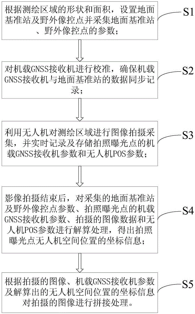
[0040] Such as figure 1 As shown, the present invention provides a method for mapping high-precision UAV images without control points, including the following steps:

[0041] S1: According to the shape and area of ​​the surveying and mapping area, set the ground reference station 1 and the field image control point 2 and collect the parameters of the ground reference station 1 and the field image control point 2;

[0042] S2: Calibrate the airborne GNSS receiver 3 to ensure that the data of the airborne GNSS receiver 3 and the ground reference station 1 are recorded synchronously;

...


PUM


Abstract

The invention discloses a high-precision unmanned aerial vehicle image non-control points surveying and mapping method and a system thereof. The method comprises the following steps: 1) setting a ground reference station and field photo-control points and collecting the parameters of the ground reference station and the field photo-control points; 2) calibrating an airborne GNSS receiver; 3) using an unmanned aerial vehicle for shooting and collecting an image for a surveying and mapping area; 4) resolving the collected ground reference station and field photo-control points parameters, an airborne GNSS receiver parameter at a shooting exposure point, an image data obtained by shooting and an unmanned aerial vehicle POS parameter; and 5) splicing the images obtained by shooting. According to the method, the images obtained by shooting as well as the data collected by the ground reference station and the field photo-control points, the airborne GNSS receiver and the unmanned aerial vehicle POS are resolved, so that an accurate coordinate at a shooting exposure time can be obtained, a step of image splicing processing is carried out by using the above information, layout of the field photo-control points can be reduced, and precision of aerial mapping of the unmanned aerial vehicle is enhanced.

Description

technical field [0001] The invention relates to the technical field of UAV aerial photogrammetry, in particular to a method and system for mapping high-precision UAV images without control points. Background technique [0002] In the current aerial photogrammetry, it is necessary to compare the aerial photos with the actual coordinates on the ground. According to the encryption requirements of traditional aerial photogrammetry, multiple image control points need to be arranged on the ground, which will double the field measurement of image control joint measurement. workload. In areas with steep terrain, water, and forests, it is difficult for collectors to reach the area where they are collected, and the layout of image control points is difficult, so it cannot meet the needs of surveying and mapping data well. Contents of the invention [0003] In view of this, it is necessary to provide a high-precision UAV image without control point surveying and mapping method and s...

Claims


Application Information

Patent Timeline
Patent Type & Authority Applications(China)
IPC IPC(8): G01C11/00G01C11/08
CPCG01C11/00G01C11/08
Inventor 张玉华夏涛张践
Owner WUHAN CANGQIONG ELECTRONICS INSTR
Why Eureka
Try Eureka