Multiscale hierarchical processing method for extracting object-oriented high-spatial resolution remote sensing information

An information extraction and object-oriented technology, which is applied in the field of remote sensing geoscience analysis, can solve the problems that macro and micro information cannot be taken into account at the same time, and achieve the effect of avoiding subjectivity and blindness, ensuring extraction accuracy, and improving overall accuracy

Inactive Publication Date: 2016-03-23
CHINA UNIV OF GEOSCIENCES (BEIJING)
View PDF8 Cites 23 Cited by
  • Summary
  • Abstract
  • Description
  • Claims
  • Application Information

AI Technical Summary

Problems solved by technology

[0009] The problem solved by the present invention is: the idea of ​​multi-scale layered processing is adopted to solve the contradiction that the macroscopic and microscopic information cannot be taken into account simultaneously in the traditional remote sensing image interpretation (image segmentation process) to a certain extent; in the layered processing process, based on The theoretical method of spatial statistics, quantitatively setting the theoretical optimal parameters of the relevant scale processing

Method used


Image

  • Multiscale hierarchical processing method for extracting object-oriented high-spatial resolution remote sensing information
  • Multiscale hierarchical processing method for extracting object-oriented high-spatial resolution remote sensing information
  • Multiscale hierarchical processing method for extracting object-oriented high-spatial resolution remote sensing information

Examples


Embodiment Construction

[0050] The specific implementation of the present invention will be further described in detail below in conjunction with the accompanying drawings and examples. The following examples are used to illustrate the present invention, but are not used to limit the scope of the present invention.

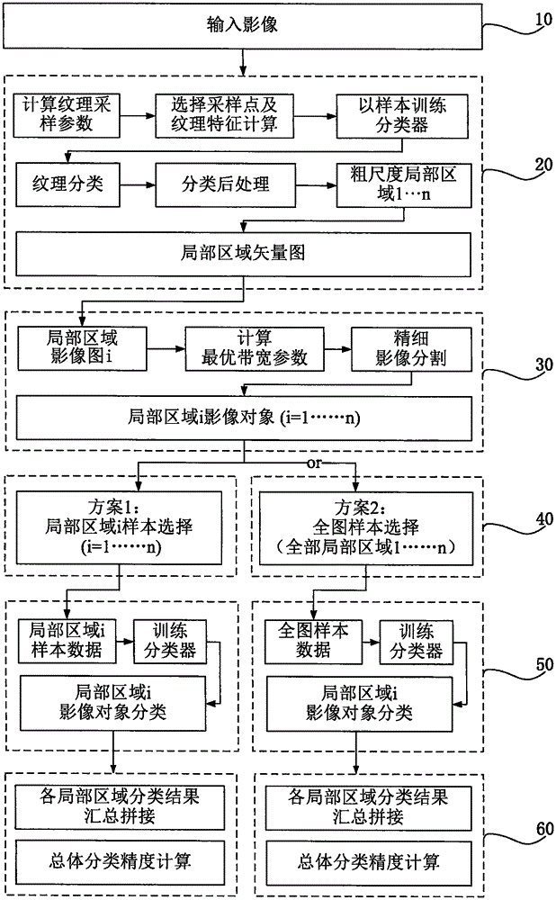
[0051] Step 10, input the remote sensing images to be classified, the present invention selects high-resolution remote sensing panchromatic or multi-spectral images.

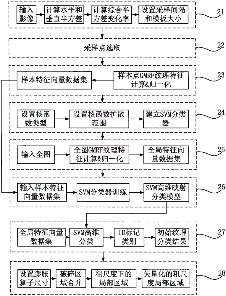
[0052] Step 20, using the GMRF-SVM method to perform texture-based classification on the entire image to obtain the divided regions at a coarse scale.

[0053] The GMRF-SVM method of this embodiment divides the region at a coarse scale, including: determining the texture sampling interval and the size of the template window, selecting representative sampling points, calculating and normalizing the GMRF feature vectors of the feature sample points, and setting the SVM Parameters, GMRF texture feature calculation, SVM classi...


PUM


Abstract

The invention discloses a multiscale hierarchical processing method for extracting object-oriented high-spatial resolution remote sensing information. The method comprises the following steps: at the global level, determining a texture sampling interval and a template window size by utilizing image semi-variance statistical calculation, and dividing the images into several local areas with smooth textures in a course scale on the basis of image texture characteristics; at the local level, setting local segmentation scale parameters through space statistical calculation by taking the local areas as units, and carrying out fine segmentation by utilizing the geometric and spectral information of the images so as to obtain refined image objects which are capable of embodying more details; and carrying out object-oriented remote sensing image classification by taking the global or local areas as units through utilizing a global or local area sample training classifier. According to the method provided by the invention, multiscale hierarchical processing is carried out, so that both the macro and micro characteristics of the images are considered and the ground features can be divided more accurately; and the specific characteristics of the remote sensing images are combined to decide whether to partition to carry out image classification, so that the classification accuracy of the whole image is improved.

Description

technical field [0001] The invention relates to the field of remote sensing geoscience analysis methods, in particular to an object-oriented multi-scale layered processing method for extracting remote sensing information with high spatial resolution. Background technique [0002] High-resolution remote sensing images have a large amount of data, complex details and scale dependence. Combined with the object-oriented image analysis method of multi-scale segmentation, it can comprehensively consider the spectrum, shape, texture and other characteristics of remote sensing images, and can express the information of high-resolution remote sensing images in a more comprehensive and multi-level manner. Therefore, the object-oriented remote sensing information extraction method is more are getting more and more attention. The accuracy of object-oriented remote sensing information extraction is closely related to image segmentation and image classification algorithms. [0003] Imag...

Claims


Application Information

Patent Timeline
Patent Type & Authority Applications(China)
IPC IPC(8): G06T7/00
CPCG06T2207/10032G06T2207/20081
Inventor 明冬萍周文闫东阳闫鹏飞陈扬洋
Owner CHINA UNIV OF GEOSCIENCES (BEIJING)
Why Eureka
Try Eureka