Time-space characteristic and cross-border mining identification method for multi-source data monitoring mining area deformation

A multi-source data and mining area technology, applied in the directions of measuring devices, surveying and navigation, height/horizontal measurement, etc., can solve the problems of high cost, low measurement efficiency, and partial measurement results, so as to improve accuracy and reliability, and identify The effect of fast speed and low false positive rate

Active Publication Date: 2016-03-30
CHINA UNIV OF MINING & TECH
View PDF2 Cites 43 Cited by
  • Summary
  • Abstract
  • Description
  • Claims
  • Application Information

AI Technical Summary

Problems solved by technology

The existing measurement methods are mainly traditional leveling and GPS measurement. The traditional measurement methods are inefficient, and the measurement results obtained are part

Method used


Image

  • Time-space characteristic and cross-border mining identification method for multi-source data monitoring mining area deformation
  • Time-space characteristic and cross-border mining identification method for multi-source data monitoring mining area deformation

Examples


Embodiment Construction

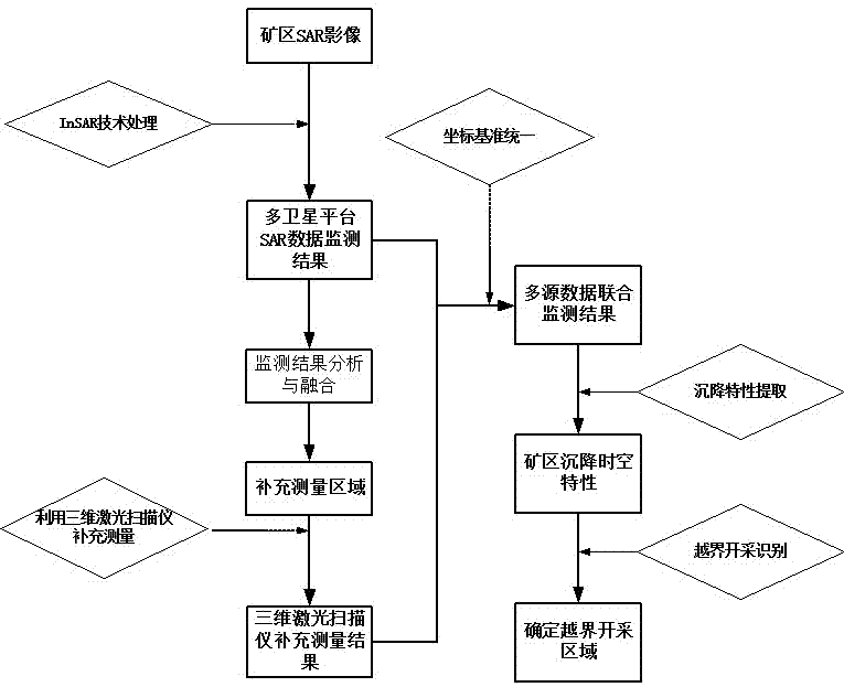
[0032] Below in conjunction with accompanying drawing, further describe the specific implementation steps of the present invention:

[0033] like figure 1 Said, the multi-source data of the present invention monitors the spatio-temporal characteristics of the deformation of the mining area and the identification method for cross-border mining, which is characterized in that it includes the following steps:

[0034] a.Use Synthetic Aperture Radar (SAR) to acquire and optimize data processing:

[0035] Using InSAR technology, the SAR sensor carried on the satellite platform obtains SAR image data covering the entire monitored mining area. The satellite platforms are: ENVISAT satellite, ALOS satellite and TerraSAR-X satellite; Select the appropriate main and auxiliary images to form an interference pair, thereby shortening the space baseline and time baseline length of the differential interference pair, and improving the accuracy and reliability of the monitoring results;

[0...


PUM


Abstract

The invention provides a time-space characteristic and cross-border mining identification method for multi-source data monitoring mining area deformation. The method comprises the following steps: firstly, obtaining and optimally processing data by using a synthetic aperture radar (SAR); fusing SAR data monitoring data of a multi-satellite platform to obtain a settlement result map; carrying out supplementary monitoring on 'a large-deformation area' or 'a de-coherence area' in a tested mining area in the fused settlement result map; unifying multi-satellite platform data monitoring result coordinates; and finally inverting time-space characteristics of surface deformation of the mining area, so as to identify a cross-border mining area. The method is simple, small in calculated quantity and high in identification efficiency, and has important theoretical value and a wide application prospect in the aspects of maintaining the mining order, ensuring the mine safety and protecting the ecological environment of the mine; and the time-space characteristics of surface deformation of the mining area can be effectively inverted.

Description

technical field [0001] The invention relates to a time-space characteristic and an identification method for out-of-boundary mining, and is especially suitable for multi-source data used in mine safety monitoring to monitor the time-space characteristics of deformation in mining areas and an identification method for out-of-boundary mining. Background technique [0002] Surface subsidence in mining areas is a real problem faced by every mining area. The surface subsidence of the mining area affects the normal mining order to a certain extent, and when the subsidence is very serious, it will affect the safety of mining activities. The existing technical means for monitoring the settlement of mining areas mainly include conventional leveling and GPS measurement. These deformation monitoring technologies are all point-based, and rely heavily on the stability of reference points, and cannot obtain a wide range of overall deformation. The new synthetic aperture radar interferome...

Claims


Application Information

Patent Timeline
IPC IPC(8): G01C5/00
CPCG01C5/00
Inventor 汪云甲赵峰胡忠波闫世勇西秀秀范洪冬
Owner CHINA UNIV OF MINING & TECH
Why Eureka
Try Eureka