
Classified extraction method of tobacco field remote sensing data

A technology of remote sensing data and extraction method, which is applied in the field of geographic information analysis of tobacco fields, and can solve the problems of increasing the difficulty of remote sensing classification and extraction of paddy fields and dry land in tobacco field areas, multiple missing points and misclassifications, and similar image texture features of ground objects.

Inactive Publication Date: 2016-05-04
GUANGDONG BRANCH OF CHINA TOBACCO GENERAL +2
View PDF2 Cites 4 Cited by
  • Summary
  • Abstract
  • Description
  • Claims
  • Application Information

AI Technical Summary

Problems solved by technology

The former has higher precision in tobacco field extraction, but has a long working cycle and high cost; the latter has faster land type information extraction and lower cost, but in areas with complex land cover types and large human activities, the results of automatic classification extraction There are still many omissions and misclassifications
In addition, during the peak growth period, the surface vegetation has similar satellite image pixel DN values, similar ground object image texture features, and complex land cover types; these increase the difficulty of remote sensing classification and extraction of paddy fields and dry land in tobacco field areas

Method used


Image

  • Classified extraction method of tobacco field remote sensing data

Examples


Embodiment 1

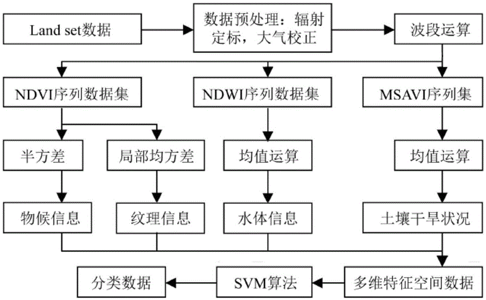
[0023] Such as figure 1 As shown, a method for classification and extraction of tobacco field remote sensing data includes the following steps:

[0024] S1: Collect monthly Landsat data sets for monitoring tobacco field areas;

[0025] S2: Perform band operation on the monthly value data set to obtain the sequence data of vegetation index, water body index and corrected soil adjustment index;

[0026] S3: Perform mean square deviation, semivariance and mean value operations on the sequence data to construct a multidimensional feature space classification data set;

[0027] S4: Use the classification algorithm to process the multi-dimensional feature space classification data set to classify the tobacco field remote sensing data.

[0028] In the present embodiment, the classification algorithm utilized in step S4 is a support vector machine algorithm; in step S3, according to the position of the peak point when the semivariance of the calculated vegetation index reaches the m...


PUM


Abstract

The present invention provides a classified extraction method of tobacco field remote sensing data. Based on the monthly data set of a land resource satellite, the sequence data of a normalized difference vegetation index (NDVI), a normalized difference water index (NDWI) and a modified soil adjusted vegetation index (MSAVI) is obtained through band operation, thus the mathematical method operations of a mean square deviation, a half square deviation and a mean value are carried out, an indicator factor with a clear physical meaning and phenological information is obtained, a multi-dimensional feature space classification data set is constructed, and a support vector machine (SVM) is operated to automatically extract the farmland type of a paddy field and a dry land in a research area. The method has a certain practical significance for the rational use of the agricultural resources of the area, and a certain reference is provided for making the policies and plans of future agricultural development in the area by related administrative departments.

Description

technical field [0001] The invention relates to the field of tobacco field geographic information analysis methods, and more specifically, to a method for classifying and extracting tobacco field remote sensing data. Background technique [0002] At present, remote sensing classification and extraction of tobacco fields focus on research on the scale of medium and high resolution remote sensing images. There are mainly two methods for farmland remote sensing extraction: 1) manual visual interpretation; 2) computer automatic classification and extraction. The former has higher precision in tobacco field extraction, but has a long working cycle and high cost; the latter has faster land type information extraction and lower cost, but in areas with complex land cover types and large human activities, the results of automatic classification extraction There are still many omissions and misclassifications. In addition, during the peak growth period, the surface vegetation has si...

Claims


Application Information

Patent Timeline
IPC IPC(8): G06K9/62
CPCG06F18/2411
Inventor 陈泽鹏张金霖陈俊林先丰唐瑞文唐建波刘柏林郭治兴
Owner GUANGDONG BRANCH OF CHINA TOBACCO GENERAL
Learn More