An archaeological excavation unit sequence three-dimensional visualization method based on multi-view images and laser scanning

A laser scanning and multi-view technology, applied in image enhancement, image analysis, image data processing, etc., can solve the problems of cumbersome data acquisition, not intuitive enough, poor precision, etc., and achieve intuitive display effect, scientific and accurate data acquisition and processing process , the effect of high spatial attribute precision

Inactive Publication Date: 2016-06-15
鲁鹏
View PDF2 Cites 23 Cited by
  • Summary
  • Abstract
  • Description
  • Claims
  • Application Information

AI Technical Summary

Problems solved by technology

[0007] The present invention aims to solve the problems of cumbersome acquisition of space data for archaeological excavation, stratum exploration and unearthed relics, poor precision, single display form and not intuitive enough, etc.

Method used


Image

  • An archaeological excavation unit sequence three-dimensional visualization method based on multi-view images and laser scanning
  • An archaeological excavation unit sequence three-dimensional visualization method based on multi-view images and laser scanning
  • An archaeological excavation unit sequence three-dimensional visualization method based on multi-view images and laser scanning

Examples


Embodiment Construction

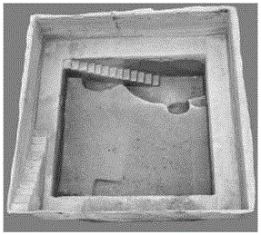
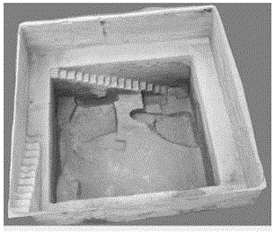
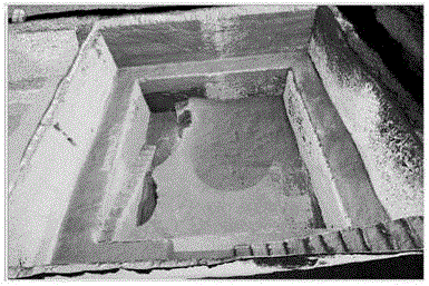
[0037] The Zhengzhou Shangcheng site is located in the built-up area of ​​Zhengzhou City. It is a site with the nature of a capital in the early and middle Shang Dynasty. It is of great significance for the study of social forms in the early and middle Shang Dynasty and the urban evolution of Zhengzhou. The excavation of the Zhengzhou Shangcheng ruins began in the 1950s. After more than half a century of excavation, we have a preliminary understanding of the cultural nature and settlement layout of Zhengzhou Shangcheng. However, due to the large scale of the site and the long duration of the excavation, some problems in the archaeological excavation gradually emerged. First of all, since the Zhengzhou Shangcheng site is located in the built-up area of ​​Zhengzhou, the rapid development of the city has had a great impact on the archaeological excavation of the site. It is difficult to find the base points for the archaeological exploration of the early excavations, which makes...


PUM


Abstract

The invention discloses an archaeological excavation unit sequence three-dimensional visualization method based on multi-view images and laser scanning. The method comprises the following steps: 1) obtaining holographic data of each archaeological site excavation unit at different periods by utilizing a three-dimensional laser scanner in periods; 2) obtaining multi-view image data of stratum, historical remains and traces of each archaeological site excavation unit at different periods; 3) carrying out 3D modeling by utilizing three-dimension scanning data and the multi-view image data under the basis of data correction and matching; and 4) carrying out multi-source data fusion on a three-dimensional model established based on the three-dimension scanning data and the multi-view image data in periods, and realizing archaeological site excavation unit sequence three-dimensional visualization. The method not only provides precise space attributes for conversion and contrast for archaeological excavation and follow-up study thereof, but also provides scientific and accurate recording mode and visual display effect for the archaeological site excavation process.

Description

technical field [0001] The invention belongs to the technical field of scientific and technological archaeology, and specifically relates to a new method for sequential three-dimensional visualization of archaeological excavation and exploration squares by using multi-view image and scanning technology. Background technique [0002] Archaeological exploration is the basic unit of archaeological excavation. For a long time, archaeological excavations (especially archaeological excavations in China) have been carried out on the basis of squares of a specific range (10m×10m, 5m×5m, etc.), and the archaeological strata and the space of unearthed relics have been recorded in units of square meters location, and display the excavation site according to the location of the excavation. The method of recording and display is mainly based on the plan and section of the location and the combination of photos. Among them, the detection plan and profile are mainly made by measuring with...

Claims


Application Information

Patent Timeline
IPC IPC(8): G06T3/40G06T5/00G06T5/50G06T7/00G06T17/00
CPCG06T3/4038G06T5/50G06T7/0004G06T17/00G06T2207/10028G06T2207/10008G06T5/70
Inventor 陈盼盼鲁鹏田燕刘伟
Owner 鲁鹏
Why Eureka
Try Eureka